
High-Flow Experiments on the Colorado River
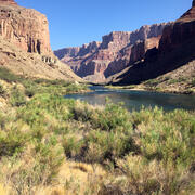
Glen Canyon Dam has altered flow and sediment dynamics of the Colorado River in Grand Canyon. Before the dam was completed in 1963, the Colorado River carried a large amount of sand, silt, and clay through Grand Canyon, some of which was deposited during spring floods to create large and abundant sandbars.
Sandbars in Grand Canyon are valued as camping areas, create aquatic and riparian habitat, and provide sand that protects archeological and cultural sites from damaging erosion. Since completion of the dam, relatively little sediment is carried into Grand Canyon.
This, coupled with an increase in average daily flows and daily flow fluctuations for power generation have caused sandbar erosion. To manage the limited sand resources in Grand Canyon, experimental high flows are conducted when conditions are favorable to rebuild eroded sandbars.
Background
The Colorado River is one of the longest rivers in the United States with its origins in the Rocky Mountains of the western United States. Historically, the river flowed into the Gulf of California; however, due to the network of dams and water diversions constructed on the Colorado River and its tributaries, it now rarely reaches the gulf.

One of those dams is Glen Canyon Dam which is located near Page, Arizona. Glen Canyon Dam construction was completed in 1963 and Lake Powell, the reservoir created by the dam, took about 17 years to completely fill. The dam and reservoir serve several purposes including water storage, flood control, generating hydroelectric power, and providing recreational opportunities.
Glen Canyon Dam has altered the dynamics of the Colorado River in Grand Canyon, including the variables that influence sandbars—river flow and fine sediment (sand, silt, and clay) supply and transport. To address this, high-flow experiments are periodically conducted.
A high-flow experiment is a release of water from Glen Canyon Dam that is much larger than the base flow that is normally released. This type of experimental flow is conducted specifically to mobilize sand from the bottom of the Colorado River to rebuild sandbars and beaches in Grand Canyon, and they generally last for several days.
An additional, and important function of this type of experiment is to provide opportunities to study sandbar development in the Colorado River and sand movement in the river and surrounding landscape within Glen Canyon (directly downstream of Glen Canyon Dam and part of Glen Canyon National Recreation Area) and Grand Canyon (including in Grand Canyon National Park).
The information gained from these experiments provide Grand Canyon National Park managers the information they need to make appropriate decisions about the park’s resources. The Grand Canyon Monitoring and Research Center, part of the Southwest Biological Science Center, conducts much of the science associated with high-flow experiments and its scientists are experts in river-based and land-based sediment movement.
Why are High-Flow Experiments Done? The Colorado River in Grand Canyon Before and After Glen Canyon Dam.

Glen Canyon Dam has influenced many aspects of the Colorado River; however, the changes to the river’s sand dynamics are the primary reason for conducting high-flow experiments. Before the dam was constructed, the Colorado River would transport large amounts of fine sediment downstream through Grand Canyon. Some would be deposited on the bed of the river, and during floods, sand would be deposited on sandbars and beaches on the margins of the river above levels of base flow.
Most of that sediment now accumulates in Lake Powell instead of being transported downstream. The Colorado River downstream of the dam now transports less than 5-20% of the sand it historically transported. Most of sand inputs now come from the Paria River, approximately 17 river miles downstream of Glen Canyon Dam, and the Little Colorado River, approximately 75 miles downstream of the dam. Both tributaries only contribute significant amounts of sediment to the Colorado River during large precipitation events.
In addition to limiting sand supply, Glen Canyon Dam has dramatically altered the flow of the Colorado River. Before the dam, the Colorado River experienced large spring snowmelt floods that were commonly 71,000 cubic feet per second (about 530,000 gallons per second) or larger, with the largest flood on record reaching approximately 210,000 cubic feet per second (about 1,571,000 gallons per second) in June 1884.
During other parts of the year, the flows could be very low with the lowest flow recorded at 1,095 cubic feet per second (about 8,200 gallons per second) in August 1934. Now, daily flows of the Colorado River are largely determined by hydroelectric power generation needs and varies between about 8,000-17,000 cubic feet per second (about 60,000-127,000 gallons per second) depending on the time of day, month, and season.
Therefore, before Glen Canyon Dam, the Colorado River experienced much higher flood flows and much lower base flows than it does today, and these changes have influenced sand dynamics in Grand Canyon. In addition to transporting and depositing large amounts of sand, Colorado River floods prior to Glen Canyon Dam would strip vegetation off sandbars. During low flow periods, much of the sand deposited on sandbars and on the channel bottom became exposed.
Wind would transport sand from those areas to sand dune fields. Many sand dune fields in Grand Canyon contain or are near important archaeological and cultural sites. Sand can provide protective cover to these sites which are otherwise prone to natural gully erosion processes caused by runoff during intense rainstorms that are common during the annual late-summer monsoon season in Grand Canyon.
The regulated flows of the modern-day Colorado River in Grand Canyon, combined with the greatly diminished sand supply, are not favorable for building or maintaining sandbars. Therefore, without high-flow events sandbars are slowly decreasing in size due to erosion. In addition, regulated flows of the modern river have caused dense stands of vegetation to encroach onto bare sand surfaces, decreasing the amount of area available for campsites in Grand Canyon.
Approximately 25,000 recreationists per year travel through Grand Canyon on the Colorado River or hike to the river, and sandbar campsites are an important part of that experience. Additionally, the expansion of riparian vegetation onto otherwise bare sand limits the amount of sand that can be blown from sandbars onto sand dune fields and fill erosional gullies. This has allowed some erosional processes to negatively affect archaeological sites and many of these sites are in danger of being damaged or lost.

High-Flow Experiments
High-Flow Experiments are conducted when enough sediment from tributaries has been deposited on the bed of the Colorado River such that sand can be mobilized to increase the size of sandbars along the margin of the river in Grand Canyon without transporting out more sand than was present prior to the tributary inputs. This occurs by allowing much larger volumes of water through Glen Canyon Dam for a few days, which transports sand from the river channel to sandbars and beaches. High-flow experiments result in water flows much higher than the typical base-operations flows from Glen Canyon Dam, with between 31,500-45,000 cubic feet per second (about 236,000-337,000 gallons per second) released during the experiments.
Although these flows are approximately half the magnitude and a fraction of the duration of the average spring snowmelt floods that occurred prior to Glen Canyon Dam, High-Flow Experiments can increase the size of sandbars in Grand Canyon. However, because the river’s modern-day flows erode sandbars over time, it is necessary to repeat High-Flow Experiments to maintain sandbars that erode during base operations. Monitoring results also suggest that there are cumulative effects of sand resupply to dune fields when annual high-flow experiments are conducted consistently in consecutive years.
High-Flow Experiments have been conducted in 1996, 2004, 2008, 2012, 2013, 2014, 2016, 2018, and 2023. Grand Canyon Monitoring and Research Center scientists continue to monitor the effects of these high-flow experiments and provide that information to resource managers and decision makers so they can make informed decisions about managing the resources of Grand Canyon.

Below are other science projects associated with this project.
Vegetation monitoring: How one square meter can tell the story of 255 river miles along the Colorado River

Riparian Vegetation in Grand Canyon: An Overview

River Sediment Dynamics

River Geomorphology, Sediment Storage, Sandbar and Campsite Monitoring in Grand Canyon

Connectivity of Sand Resources Along the Colorado River in Grand Canyon
Glen Canyon Dam has altered flow and sediment dynamics of the Colorado River in Grand Canyon. Before the dam was completed in 1963, the Colorado River carried a large amount of sand, silt, and clay through Grand Canyon, some of which was deposited during spring floods to create large and abundant sandbars.
Sandbars in Grand Canyon are valued as camping areas, create aquatic and riparian habitat, and provide sand that protects archeological and cultural sites from damaging erosion. Since completion of the dam, relatively little sediment is carried into Grand Canyon.
This, coupled with an increase in average daily flows and daily flow fluctuations for power generation have caused sandbar erosion. To manage the limited sand resources in Grand Canyon, experimental high flows are conducted when conditions are favorable to rebuild eroded sandbars.
Background
The Colorado River is one of the longest rivers in the United States with its origins in the Rocky Mountains of the western United States. Historically, the river flowed into the Gulf of California; however, due to the network of dams and water diversions constructed on the Colorado River and its tributaries, it now rarely reaches the gulf.
One of those dams is Glen Canyon Dam which is located near Page, Arizona. Glen Canyon Dam construction was completed in 1963 and Lake Powell, the reservoir created by the dam, took about 17 years to completely fill. The dam and reservoir serve several purposes including water storage, flood control, generating hydroelectric power, and providing recreational opportunities.
Glen Canyon Dam has altered the dynamics of the Colorado River in Grand Canyon, including the variables that influence sandbars—river flow and fine sediment (sand, silt, and clay) supply and transport. To address this, high-flow experiments are periodically conducted.
A high-flow experiment is a release of water from Glen Canyon Dam that is much larger than the base flow that is normally released. This type of experimental flow is conducted specifically to mobilize sand from the bottom of the Colorado River to rebuild sandbars and beaches in Grand Canyon, and they generally last for several days.
An additional, and important function of this type of experiment is to provide opportunities to study sandbar development in the Colorado River and sand movement in the river and surrounding landscape within Glen Canyon (directly downstream of Glen Canyon Dam and part of Glen Canyon National Recreation Area) and Grand Canyon (including in Grand Canyon National Park).
The information gained from these experiments provide Grand Canyon National Park managers the information they need to make appropriate decisions about the park’s resources. The Grand Canyon Monitoring and Research Center, part of the Southwest Biological Science Center, conducts much of the science associated with high-flow experiments and its scientists are experts in river-based and land-based sediment movement.
Why are High-Flow Experiments Done? The Colorado River in Grand Canyon Before and After Glen Canyon Dam.
Glen Canyon Dam has influenced many aspects of the Colorado River; however, the changes to the river’s sand dynamics are the primary reason for conducting high-flow experiments. Before the dam was constructed, the Colorado River would transport large amounts of fine sediment downstream through Grand Canyon. Some would be deposited on the bed of the river, and during floods, sand would be deposited on sandbars and beaches on the margins of the river above levels of base flow.
Most of that sediment now accumulates in Lake Powell instead of being transported downstream. The Colorado River downstream of the dam now transports less than 5-20% of the sand it historically transported. Most of sand inputs now come from the Paria River, approximately 17 river miles downstream of Glen Canyon Dam, and the Little Colorado River, approximately 75 miles downstream of the dam. Both tributaries only contribute significant amounts of sediment to the Colorado River during large precipitation events.
In addition to limiting sand supply, Glen Canyon Dam has dramatically altered the flow of the Colorado River. Before the dam, the Colorado River experienced large spring snowmelt floods that were commonly 71,000 cubic feet per second (about 530,000 gallons per second) or larger, with the largest flood on record reaching approximately 210,000 cubic feet per second (about 1,571,000 gallons per second) in June 1884.
During other parts of the year, the flows could be very low with the lowest flow recorded at 1,095 cubic feet per second (about 8,200 gallons per second) in August 1934. Now, daily flows of the Colorado River are largely determined by hydroelectric power generation needs and varies between about 8,000-17,000 cubic feet per second (about 60,000-127,000 gallons per second) depending on the time of day, month, and season.
Therefore, before Glen Canyon Dam, the Colorado River experienced much higher flood flows and much lower base flows than it does today, and these changes have influenced sand dynamics in Grand Canyon. In addition to transporting and depositing large amounts of sand, Colorado River floods prior to Glen Canyon Dam would strip vegetation off sandbars. During low flow periods, much of the sand deposited on sandbars and on the channel bottom became exposed.
Wind would transport sand from those areas to sand dune fields. Many sand dune fields in Grand Canyon contain or are near important archaeological and cultural sites. Sand can provide protective cover to these sites which are otherwise prone to natural gully erosion processes caused by runoff during intense rainstorms that are common during the annual late-summer monsoon season in Grand Canyon.
The regulated flows of the modern-day Colorado River in Grand Canyon, combined with the greatly diminished sand supply, are not favorable for building or maintaining sandbars. Therefore, without high-flow events sandbars are slowly decreasing in size due to erosion. In addition, regulated flows of the modern river have caused dense stands of vegetation to encroach onto bare sand surfaces, decreasing the amount of area available for campsites in Grand Canyon.
Approximately 25,000 recreationists per year travel through Grand Canyon on the Colorado River or hike to the river, and sandbar campsites are an important part of that experience. Additionally, the expansion of riparian vegetation onto otherwise bare sand limits the amount of sand that can be blown from sandbars onto sand dune fields and fill erosional gullies. This has allowed some erosional processes to negatively affect archaeological sites and many of these sites are in danger of being damaged or lost.
High-Flow Experiments
High-Flow Experiments are conducted when enough sediment from tributaries has been deposited on the bed of the Colorado River such that sand can be mobilized to increase the size of sandbars along the margin of the river in Grand Canyon without transporting out more sand than was present prior to the tributary inputs. This occurs by allowing much larger volumes of water through Glen Canyon Dam for a few days, which transports sand from the river channel to sandbars and beaches. High-flow experiments result in water flows much higher than the typical base-operations flows from Glen Canyon Dam, with between 31,500-45,000 cubic feet per second (about 236,000-337,000 gallons per second) released during the experiments.
Although these flows are approximately half the magnitude and a fraction of the duration of the average spring snowmelt floods that occurred prior to Glen Canyon Dam, High-Flow Experiments can increase the size of sandbars in Grand Canyon. However, because the river’s modern-day flows erode sandbars over time, it is necessary to repeat High-Flow Experiments to maintain sandbars that erode during base operations. Monitoring results also suggest that there are cumulative effects of sand resupply to dune fields when annual high-flow experiments are conducted consistently in consecutive years.
High-Flow Experiments have been conducted in 1996, 2004, 2008, 2012, 2013, 2014, 2016, 2018, and 2023. Grand Canyon Monitoring and Research Center scientists continue to monitor the effects of these high-flow experiments and provide that information to resource managers and decision makers so they can make informed decisions about managing the resources of Grand Canyon.
Below are other science projects associated with this project.
Vegetation monitoring: How one square meter can tell the story of 255 river miles along the Colorado River
Riparian Vegetation in Grand Canyon: An Overview
River Sediment Dynamics
River Geomorphology, Sediment Storage, Sandbar and Campsite Monitoring in Grand Canyon