
Geologic Evolution of Cat Island, Mississippi
The geologic evolution of Cat Island has been influenced by deltaic, lagoonal/estuarine, tidal, and oceanographic processes, resulting in a complex stratigraphic record.
Cat Island: Complex Geomorphic Evolution of a Barrier Island
The geologic evolution of Cat Island has been influenced by deltaic, lagoonal/estuarine, tidal, and oceanographic processes, resulting in a complex stratigraphic record.
Understanding the geomorphic evolution of Cat Island, Mississippi, was identified as critical for understanding the Holocene evolution of the Mississippi-Alabama (MS-AL) barrier islands in the northern Gulf of America. Cat Island is considered the most "stable" of the MS-AL barrier islands because it is not migrating or suffering from rapid land loss that characterizes the historic response of most of the other islands. Prior to this study, there was a lack of comprehensive data needed to fully understand the geologic influences on the historic evolution of Cat Island and how its geology and geomorphology related to the other MS-AL islands to the east and the Chandeleur Islands to the south. In order to place Cat Island in the broader context of the evolution of the northern Gulf of America coastal system, it is important to understand the morphology of the island and the seafloor surrounding it, sediment distribution, and stratigraphy, all of which contribute essential information about the geomorphologic evolution of the island over geologic and historical time scales. This provides geologic context for variability in modern nearshore processes and storm response, which will ultimately determine future island morphology.


Scientists from the USGS St. Petersburg Coastal and Marine Science Center, in collaboration with the U.S. Army Corps of Engineers, conducted geophysical and sedimentological surveys in 2010 around Cat Island, Mississippi. Over 487 line kilometers (> 300 mi) of high-resolution geophysical data were collected to improve understanding of the island’s geologic evolution and identify potential sand resources for coastal restoration. In addition, 40 vibracores were collected on and around the island, from which more than 350 samples were selected for grain-size analysis.

The results indicate that the geologic evolution of Cat Island has been influenced by deltaic, lagoonal/estuarine, tidal, and oceanographic processes, resulting in a stratigraphic record that is quite complex. The region north of the island is dominated by lagoonal/estuarine deposition, whereas the region south of the island is dominated by deltaic (finer-grained sediments) and oceanographic (coarser-grained sediments) deposition. The extent and thickness of deltaic sediments south and east of the island is particularly important because they contain very little sand that could be liberated from the shoreface as sea level rises to maintain the island footprint. Furthermore, Middle Spit, a landform just south of the E-W segment of Cat Island, appears to be underlain completely or in part by deltaic sediments, which may lead to increased rates of subsidence for that section of the island.
In addition to identifying deltaic deposits, the data reveal four sand units around the island: two northwest and two southwest of the modern island. Given the dominant, westward-directed, longshore transport along the MS-AL barrier islands, the geographic location of these four units suggests that they do not contribute to the modern sediment budget of Cat Island, making them potential sand resources for coastal restoration. Another sand deposit was identified directly east of the island, which represents part of the island platform that existed ~4000 years ago and has supplied sand over that time for creation of the spits that form the eastern shoreline. Because of its location east of the island, this unit may still supply sediment to the island today. Data collected as part of this study showed the variety of processes that contributed to the geologic history of Cat Island and revealed how those processes may affect the future evolution of the island. To view the full Cat Island report, please see Kindinger and others (2014).

Objectives
- Use a comprehensive marine and terrestrial approach to understand the geologic evolution of Cat Island
- Define evolutionary relationships between Cat Island the other MS-AL barrier islands
- Identify sand resources
Methodology
Geophysical Data - Swath and single-beam bathymetry, side-scan sonar, and seismic
Approximately 487 line-km of data were collected utilizing an integrated suite of geophysical instruments capable of mapping the geologic environment around the island in three dimensions. An interferometer provided swath bathymetry (e.g., water depth or submerged elevation). A side-scan sonar system provided information about seafloor composition (e.g., sand vs. mud), and high-resolution chirp seismic reflection was used to characterize sub-seafloor sediments. Survey tracklines (76 lines) were shore parallel for swath bathymetry with spacing of approximately 300 m. In addition, 274 line-km of single-beam bathymetry data were collected in the shallow water around Cat Island. Seismic data methods and processed data can be found in Forde and others (2012). Bathymetry and side-scan sonar data collection methods, processing methods, and digital elevation model (DEM) can be found in Buster and others (2012).
Sedimentologic Data - Vibracores
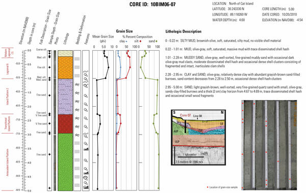
Seismic data was used to select sites for 29 marine vibracores collected for this study. In addition, 11 terrestrial cores were collected from the island within the swales between beach ridges. Grain-size analysis provided information on the texture and composition of marine units. Radiocarbon and optically-stimulated luminescence (OSL) dating were used for sediment chronology. Data collection methods, laboratory methods, core photos, and descriptions can be found in Buster and others (2014).

Data Synthesis
- Bathymetric and side-scan sonar data were combined to identify morphology-sediment relationships around the island. Analysis showed that coarser grained sediments were adjacent to the modern island and finer grained sediments were associated with bathymetric lows, such as channels.
- Seismic data and marine vibracores were integrated to produce three-dimensional maps of the geology beneath the seafloor. By combining the two datasets, the composition and extent of the units could be determined, enabling an analysis of their area, volume, and suitability as resources.
- Photographs, physical descriptions, grain-size analysis, radiocarbon dating, and OSL dating were assimilated to provide temporal context for the observed stratigraphy.
- Comparisons to data collected from the Chandeleur Islands, LA (Twichell and others, 2009) and south of Ship Island (Twichell and others, 2011) show relationships between the Mississippi River Delta and barrier island evolution in the northern Gulf of America.
This research is part of the Geologic and Morphologic Evolution of Coastal Margins project.
This research is part of the Geologic and Morphologic Evolution of Coastal Margins project. Listed below are links to that project and related resarch tasks.

Geologic and Morphologic Evolution of Coastal Margins

Barrier Island Comprehensive Monitoring

Subsidence and Coastal Geomorphic Change in South-Central Louisiana

Integrating Mapping and Modeling to Support the Restoration of Bird Nesting Habitat at Breton Island National Wildlife Refuge

Science Support for the Mississippi Coastal Improvement Project
Geologic and Morphologic Evolution of Coastal Margins
The geologic evolution of Cat Island has been influenced by deltaic, lagoonal/estuarine, tidal, and oceanographic processes, resulting in a complex stratigraphic record.
Cat Island: Complex Geomorphic Evolution of a Barrier Island
The geologic evolution of Cat Island has been influenced by deltaic, lagoonal/estuarine, tidal, and oceanographic processes, resulting in a complex stratigraphic record.
Understanding the geomorphic evolution of Cat Island, Mississippi, was identified as critical for understanding the Holocene evolution of the Mississippi-Alabama (MS-AL) barrier islands in the northern Gulf of America. Cat Island is considered the most "stable" of the MS-AL barrier islands because it is not migrating or suffering from rapid land loss that characterizes the historic response of most of the other islands. Prior to this study, there was a lack of comprehensive data needed to fully understand the geologic influences on the historic evolution of Cat Island and how its geology and geomorphology related to the other MS-AL islands to the east and the Chandeleur Islands to the south. In order to place Cat Island in the broader context of the evolution of the northern Gulf of America coastal system, it is important to understand the morphology of the island and the seafloor surrounding it, sediment distribution, and stratigraphy, all of which contribute essential information about the geomorphologic evolution of the island over geologic and historical time scales. This provides geologic context for variability in modern nearshore processes and storm response, which will ultimately determine future island morphology.
Scientists from the USGS St. Petersburg Coastal and Marine Science Center, in collaboration with the U.S. Army Corps of Engineers, conducted geophysical and sedimentological surveys in 2010 around Cat Island, Mississippi. Over 487 line kilometers (> 300 mi) of high-resolution geophysical data were collected to improve understanding of the island’s geologic evolution and identify potential sand resources for coastal restoration. In addition, 40 vibracores were collected on and around the island, from which more than 350 samples were selected for grain-size analysis.
The results indicate that the geologic evolution of Cat Island has been influenced by deltaic, lagoonal/estuarine, tidal, and oceanographic processes, resulting in a stratigraphic record that is quite complex. The region north of the island is dominated by lagoonal/estuarine deposition, whereas the region south of the island is dominated by deltaic (finer-grained sediments) and oceanographic (coarser-grained sediments) deposition. The extent and thickness of deltaic sediments south and east of the island is particularly important because they contain very little sand that could be liberated from the shoreface as sea level rises to maintain the island footprint. Furthermore, Middle Spit, a landform just south of the E-W segment of Cat Island, appears to be underlain completely or in part by deltaic sediments, which may lead to increased rates of subsidence for that section of the island.
In addition to identifying deltaic deposits, the data reveal four sand units around the island: two northwest and two southwest of the modern island. Given the dominant, westward-directed, longshore transport along the MS-AL barrier islands, the geographic location of these four units suggests that they do not contribute to the modern sediment budget of Cat Island, making them potential sand resources for coastal restoration. Another sand deposit was identified directly east of the island, which represents part of the island platform that existed ~4000 years ago and has supplied sand over that time for creation of the spits that form the eastern shoreline. Because of its location east of the island, this unit may still supply sediment to the island today. Data collected as part of this study showed the variety of processes that contributed to the geologic history of Cat Island and revealed how those processes may affect the future evolution of the island. To view the full Cat Island report, please see Kindinger and others (2014).
Objectives
- Use a comprehensive marine and terrestrial approach to understand the geologic evolution of Cat Island
- Define evolutionary relationships between Cat Island the other MS-AL barrier islands
- Identify sand resources
Methodology
Geophysical Data - Swath and single-beam bathymetry, side-scan sonar, and seismic
Approximately 487 line-km of data were collected utilizing an integrated suite of geophysical instruments capable of mapping the geologic environment around the island in three dimensions. An interferometer provided swath bathymetry (e.g., water depth or submerged elevation). A side-scan sonar system provided information about seafloor composition (e.g., sand vs. mud), and high-resolution chirp seismic reflection was used to characterize sub-seafloor sediments. Survey tracklines (76 lines) were shore parallel for swath bathymetry with spacing of approximately 300 m. In addition, 274 line-km of single-beam bathymetry data were collected in the shallow water around Cat Island. Seismic data methods and processed data can be found in Forde and others (2012). Bathymetry and side-scan sonar data collection methods, processing methods, and digital elevation model (DEM) can be found in Buster and others (2012).
Sedimentologic Data - Vibracores
Seismic data was used to select sites for 29 marine vibracores collected for this study. In addition, 11 terrestrial cores were collected from the island within the swales between beach ridges. Grain-size analysis provided information on the texture and composition of marine units. Radiocarbon and optically-stimulated luminescence (OSL) dating were used for sediment chronology. Data collection methods, laboratory methods, core photos, and descriptions can be found in Buster and others (2014).
Data Synthesis
- Bathymetric and side-scan sonar data were combined to identify morphology-sediment relationships around the island. Analysis showed that coarser grained sediments were adjacent to the modern island and finer grained sediments were associated with bathymetric lows, such as channels.
- Seismic data and marine vibracores were integrated to produce three-dimensional maps of the geology beneath the seafloor. By combining the two datasets, the composition and extent of the units could be determined, enabling an analysis of their area, volume, and suitability as resources.
- Photographs, physical descriptions, grain-size analysis, radiocarbon dating, and OSL dating were assimilated to provide temporal context for the observed stratigraphy.
- Comparisons to data collected from the Chandeleur Islands, LA (Twichell and others, 2009) and south of Ship Island (Twichell and others, 2011) show relationships between the Mississippi River Delta and barrier island evolution in the northern Gulf of America.
This research is part of the Geologic and Morphologic Evolution of Coastal Margins project.
This research is part of the Geologic and Morphologic Evolution of Coastal Margins project. Listed below are links to that project and related resarch tasks.
Geologic and Morphologic Evolution of Coastal Margins
Barrier Island Comprehensive Monitoring
Subsidence and Coastal Geomorphic Change in South-Central Louisiana
Integrating Mapping and Modeling to Support the Restoration of Bird Nesting Habitat at Breton Island National Wildlife Refuge
Science Support for the Mississippi Coastal Improvement Project