
2020 Systemic Land Cover/Land Use Aerial Imagery Acquisition, Image Interpretation, and Spatial Data Products for the Upper Mississippi River System
The U.S. Army Corps of Engineers (USACE) Upper Mississippi River Restoration (UMRR) program, through its Long Term Resource Monitoring (UMRR-LTRM) element, is completing the 2020 decadal update of Land Cover/Land Use (LCU) for the entire Upper Mississippi River System (UMRS). Dissemination of the 2020 LCU database will provide a fourth systemic dataset to compare to the 1989, 2000, and 2010/11 systemic coverages. While a crosswalk was used to update 1989 (originally interpreted using a different classification system), the 2000, 2010/11, and 2020 LCU datasets will share the same vegetation classification system and image interpreters, making them directly comparable. Built upon systemic 4-band (red, green, blue, and near-infrared) imagery collected in the summer of 2020, the 2020 dataset will be an invaluable additional dataset for assessing the current state of floodplain vegetation, as well as evaluating long-term vegetation trends and habitat changes that have occurred over the past 30 years.
An LCU Geographic Information System (GIS) database for Pools 1-26, the Open River Reach, the entire Illinois River, and the navigable portions of the Minnesota, St. Croix, and Kaskaskia Rivers of the UMRS, based on four-band (red, green, blue, and near-infrared) digital aerial imagery collected in the summer of 2020, is being generated and served online by navigation pool (the stretch of river between locks and dams). These datasets will overlay the associated pool-based aerial image mosaics using commonly available GIS software. The databases provide a general description of the vegetation along with density and, if applicable, height along with additional information. The aerial mosaics can be displayed in natural color or color infrared and provide visual context to the 2020 database as well as the previous LCU databases. Resource managers, scientists, or anyone with an interest in the UMRS can download all 2020 LCU data as it is completed along with past LCU and aerial imagery products LCU 2020 Vector Data (usgs.gov) with imagery datasets available for download at LCU 2020 Raster Data (usgs.gov).

Figure 1: Paired imagery of Lock & Dam 7, La Crescent, MN in true color (left) and color-infrared (right).
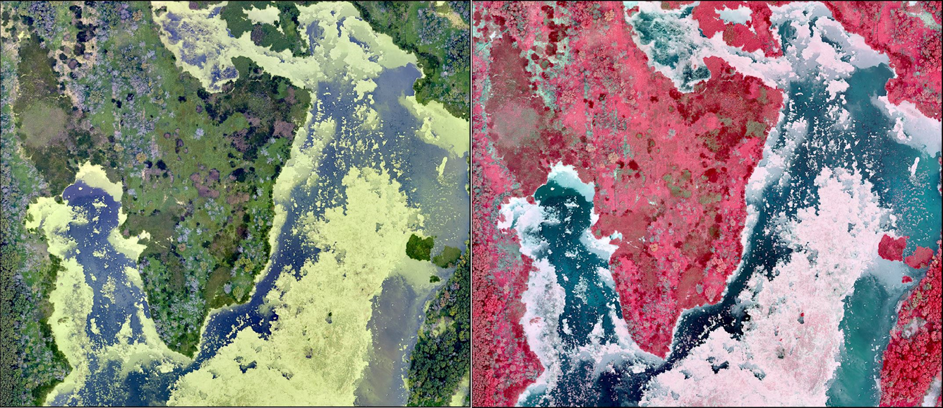
Figure 2: Paired imagery of a forested aquatic marsh in Goose Island County Park, La Crosse County, WI, in true color (left) and color-infrared (right).
The U.S. Army Corps of Engineers (USACE) Upper Mississippi River Restoration (UMRR) program, through its Long Term Resource Monitoring (UMRR-LTRM) element, is completing the 2020 decadal update of Land Cover/Land Use (LCU) for the entire Upper Mississippi River System (UMRS). Dissemination of the 2020 LCU database will provide a fourth systemic dataset to compare to the 1989, 2000, and 2010/11 systemic coverages. While a crosswalk was used to update 1989 (originally interpreted using a different classification system), the 2000, 2010/11, and 2020 LCU datasets will share the same vegetation classification system and image interpreters, making them directly comparable. Built upon systemic 4-band (red, green, blue, and near-infrared) imagery collected in the summer of 2020, the 2020 dataset will be an invaluable additional dataset for assessing the current state of floodplain vegetation, as well as evaluating long-term vegetation trends and habitat changes that have occurred over the past 30 years.
An LCU Geographic Information System (GIS) database for Pools 1-26, the Open River Reach, the entire Illinois River, and the navigable portions of the Minnesota, St. Croix, and Kaskaskia Rivers of the UMRS, based on four-band (red, green, blue, and near-infrared) digital aerial imagery collected in the summer of 2020, is being generated and served online by navigation pool (the stretch of river between locks and dams). These datasets will overlay the associated pool-based aerial image mosaics using commonly available GIS software. The databases provide a general description of the vegetation along with density and, if applicable, height along with additional information. The aerial mosaics can be displayed in natural color or color infrared and provide visual context to the 2020 database as well as the previous LCU databases. Resource managers, scientists, or anyone with an interest in the UMRS can download all 2020 LCU data as it is completed along with past LCU and aerial imagery products LCU 2020 Vector Data (usgs.gov) with imagery datasets available for download at LCU 2020 Raster Data (usgs.gov).
Figure 1: Paired imagery of Lock & Dam 7, La Crescent, MN in true color (left) and color-infrared (right).
Figure 2: Paired imagery of a forested aquatic marsh in Goose Island County Park, La Crosse County, WI, in true color (left) and color-infrared (right).