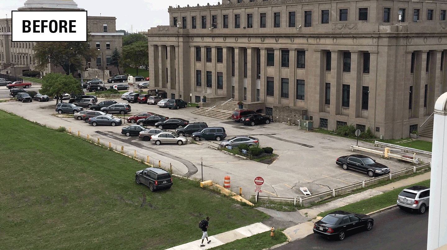
The effectiveness of green infrastructure (rain gardens and decreased impervious surface) at reducing stormwater runoff and capturing dissolved chloride is being assessed at a redevelopment project at Gary City Hall (Gary, Indiana). This study will evaluate pre- and post-construction hydrologic conditions using data collected by monitoring storm-sewer flow, groundwater levels, soil moisture, and meteorological conditions. The fate of chloride dissolved in runoff that enters the rain garden will be assessed with hydrologic, aqueous chemistry, soil chemistry, and soil permeability measurements. Numerical models will be evaluated using field-collected data.
Incorporating green infrastructure into urban development
Gary, Indiana, is located on the southern-most shore of Lake Michigan and is representative of the Great Lakes’ coastal sandy soils and subsurface deposits that encourage infiltration. In many urban watersheds, including Gary, stormwater (excess rainfall or snowmelt that is not absorbed by the ground) can cause problems such as flooding, erosion, and sedimentation; property and habitat damage; harm to fish and aquatic organisms; and decreased water quality. Due to Gary’s location in the snow belt of the Midwest, the application of road salt to keep roads and sidewalks clear during winter weather is common practice for four to six months of the year.
Like others in the Great Lakes basin, the City of Gary is investing in the redevelopment of abandoned areas in its urban core and is interested in exploring the potential stormwater-reduction benefits of green infrastructure. Green infrastructure is a group of urban stormwater control measures that use natural processes to reduce or delay peak flows of stormwater runoff by holding stormwater on-site, encouraging infiltration, and enhancing evapotranspiration (ET). One particular area surrounding Gary’s City Hall is currently undergoing redevelopment. As vacant properties are removed, those lands are being repurposed using types of development that enhance stormwater infiltration, increase opportunities for adding green space, and minimize stormwater loads by redirecting runoff towards groundwater recharge.
The City of Gary recently redeveloped one of their parking lots south of City Hall using green infrastructure and invited USGS hydrologists to work with the design team to incorporate a monitoring plan and equipment installation into the reconstruction. The redevelopment included the removal of impervious cover, installation of structures to redirect runoff from the storm-sewer system and parking lot to a central rain garden, and the addition of peripheral grassed areas. The USGS worked with the landscape engineers to ensure that the features included in the final design allowed monitoring of surface inflows and groundwater conditions within the rain garden infrastructure. The city is also planning additional redevelopment that may include the redirection of rooftop stormwater from downspouts on the City Hall roof to additional rain gardens and a permeable paver plaza for community events.
Study Objectives
In collaboration with the City of Gary and the Great Lakes Restoration Initiative (GLRI), this study will quantify the effects of planned stormwater reduction strategies and infrastructure on the hydrology of the highly permeable surficial aquifer material and storm-sewer flows. By monitoring conditions before and after the installation of green infrastructure, this study will assess:
- Volume of precipitation and snowmelt at the green infrastructure installation and a control site
- Volume of water lost to evapotranspiration
- Discharge to storm sewers in order to characterize changes in runoff volume due to increased infiltration
- Changes in the volume of stormwater treated and infiltrated, and other hydrologic characteristics
- The origin and fate of chloride entering the rain garden
- The effect of chloride on the chemistry and properties of soils in the rain garden
Study Description
Monitoring: The USGS installed and monitored a network of groundwater observation wells, soil moisture sites, storm sewers, flumes, and a weather station from 2016 to 2021 to understand the effects of the rain garden and other green infrastructure on stormwater reduction. The data-collection network was monitored by USGS before and after site rehabilitation (including the installation of green infrastructure) to fully understand the effect on the water budget. Soil moisture and groundwater levels were monitored in nearby parkland areas with no land-use change (the control site) for the length of the project to use for comparison purposes. Continuous specific conductance and discrete groundwater and runoff samples analyzed for chloride, bromide and iodide will be used to assess the origin and fate of those constituents. Soil samples were collected and analyzed before and after the deicer-application season for chemical and physical properties. Soil permeability was measured on the same general schedule using a double-ring infiltrometer.
Modeling: The installation at Gary City Hall is being modeled with two stormwater-routing models using hydrologic data collected at Gary City Hall to estimate the effectiveness of the stormwater reduction infrastructure. Comparisons with field data and model intercomparisons will be used to evaluate and improve the models and qualify the accuracy for applications to future sites.
Benefits
This study addresses both the mitigation of adverse impacts of stormwater runoff and the development of approaches to rehabilitate abandoned land in urban settings, both of which are major issues within urban areas of the Great Lakes. The effectiveness of stormwater infiltration structures have been measured in environments with low permeability surficial sediments, but such systems have not been studied or monitored in highly permeable environments (like that of northwestern Indiana). The data gathered through this study can be used to model the application of similar infrastructure in urban areas with abandoned lands showing the potential effects on groundwater and discharge to storm sewers and surface waters.
By monitoring the hydrologic conditions before and after redevelopment and comparing the redeveloped site against a control site, the effectiveness of the green infrastructure to alter the urban water cycle by diverting stormwater and promoting evapotranspiration and infiltration can be measured. Data from this study will be used to evaluate the benefits of future redevelopment proposals to reduce impervious cover and remove vacant housing, for replacement with green space and green infrastructure.
Results
Monitoring at Gary's City Hall concluded in the spring of 2021. Click on the links below to view data and access historical measurements. Results from the projects will be summarized in a series of USGS Scientific Investigations Reports that will be posted when completed.
Monitoring locations
Pre-Construction
A webcam was installed to monitor construction activities and site conditions.
Prior to site construction, the following sites were installed onsite and began collecting data in May of 2016:
One weather station measuring local meteorological conditions that will be used to estimate potential evapotranspiration.
Four groundwater monitoring wells paired with three soil moisture sensors each to measure the groundwater elevations and the response to precipitation events (recharge):
Located adjacent to City Hall:
Located in nearby Gary City Parks:
- Gateway Park
- Buffington Park (not real-time)
One storm sewer pipe monitor with webcam to measure stormwater runoff discharging to the City’s storm sewer from the parking lot drains south of city hall and for gage height quality assurance.
Post-Construction
Following the completion of construction on the storm water reduction infrastructure in June 2017, the following additional monitoring equipment was installed:
Five flumes to measure the amount and specific conductance of water entering the rain garden from the surrounding parking lot and roadway:
Three pairs of soil moisture sensors below the rain garden:
One storm sewer pipe monitor to measure discharge to the City’s storm sewer from the rain garden overflow structure.
Below are other science projects associated with GLRI Urban Stormwater Monitoring.
GLRI Urban Stormwater Monitoring
Rapid Assessment of Green Infrastructure to Inform Future Implementation in the Great Lakes
Assessing stormwater reduction through green infrastructure: RecoveryPark (Detroit, Mich.)
Monitoring and predicting the impacts of trees on urban stormwater volume reduction
Assessing stormwater reduction using green infrastructure: Niagara River Greenway Project (Buffalo, NY)
Below are multimedia items associated with the GLRI Urban Stormwater Monitoring green infrastructure assessment study at City Hall in Gary, Indiana.
Below are publications associated with the GLRI Urban Stormwater Monitoring green infrastructure assessment study at City Hall in Gary, Indiana.
Stormwater reduction and water budget for a rain garden on sandy soil, Gary, Indiana, 2016–18
Below are partners associated with the GLRI Urban Stormwater Monitoring green infrastructure assessment study at City Hall in Gary, Indiana.
- Overview
The effectiveness of green infrastructure (rain gardens and decreased impervious surface) at reducing stormwater runoff and capturing dissolved chloride is being assessed at a redevelopment project at Gary City Hall (Gary, Indiana). This study will evaluate pre- and post-construction hydrologic conditions using data collected by monitoring storm-sewer flow, groundwater levels, soil moisture, and meteorological conditions. The fate of chloride dissolved in runoff that enters the rain garden will be assessed with hydrologic, aqueous chemistry, soil chemistry, and soil permeability measurements. Numerical models will be evaluated using field-collected data.
Incorporating green infrastructure into urban development
Gary, Indiana, is located on the southern-most shore of Lake Michigan and is representative of the Great Lakes’ coastal sandy soils and subsurface deposits that encourage infiltration. In many urban watersheds, including Gary, stormwater (excess rainfall or snowmelt that is not absorbed by the ground) can cause problems such as flooding, erosion, and sedimentation; property and habitat damage; harm to fish and aquatic organisms; and decreased water quality. Due to Gary’s location in the snow belt of the Midwest, the application of road salt to keep roads and sidewalks clear during winter weather is common practice for four to six months of the year.
Like others in the Great Lakes basin, the City of Gary is investing in the redevelopment of abandoned areas in its urban core and is interested in exploring the potential stormwater-reduction benefits of green infrastructure. Green infrastructure is a group of urban stormwater control measures that use natural processes to reduce or delay peak flows of stormwater runoff by holding stormwater on-site, encouraging infiltration, and enhancing evapotranspiration (ET). One particular area surrounding Gary’s City Hall is currently undergoing redevelopment. As vacant properties are removed, those lands are being repurposed using types of development that enhance stormwater infiltration, increase opportunities for adding green space, and minimize stormwater loads by redirecting runoff towards groundwater recharge.
Gary City Hall (Indiana), before and after redevelopment with green infrastructure The City of Gary recently redeveloped one of their parking lots south of City Hall using green infrastructure and invited USGS hydrologists to work with the design team to incorporate a monitoring plan and equipment installation into the reconstruction. The redevelopment included the removal of impervious cover, installation of structures to redirect runoff from the storm-sewer system and parking lot to a central rain garden, and the addition of peripheral grassed areas. The USGS worked with the landscape engineers to ensure that the features included in the final design allowed monitoring of surface inflows and groundwater conditions within the rain garden infrastructure. The city is also planning additional redevelopment that may include the redirection of rooftop stormwater from downspouts on the City Hall roof to additional rain gardens and a permeable paver plaza for community events.
Study Objectives
In collaboration with the City of Gary and the Great Lakes Restoration Initiative (GLRI), this study will quantify the effects of planned stormwater reduction strategies and infrastructure on the hydrology of the highly permeable surficial aquifer material and storm-sewer flows. By monitoring conditions before and after the installation of green infrastructure, this study will assess:
- Volume of precipitation and snowmelt at the green infrastructure installation and a control site
- Volume of water lost to evapotranspiration
- Discharge to storm sewers in order to characterize changes in runoff volume due to increased infiltration
- Changes in the volume of stormwater treated and infiltrated, and other hydrologic characteristics
- The origin and fate of chloride entering the rain garden
- The effect of chloride on the chemistry and properties of soils in the rain garden
Gary City Hall green-infrastructure monitoring equipment Study Description
Randy Bayless (kneeling), USGS Research Hydrologist; Caleb Artz (standing in yellow), USGS Hydrologic Technician; and Danielle Szymkowski (standing in red), USGS Contractor; collect a groundwater sample from well CH-3 (USGS Station ID: 413611087201004) at the Gary City Hall rain garden. Monitoring: The USGS installed and monitored a network of groundwater observation wells, soil moisture sites, storm sewers, flumes, and a weather station from 2016 to 2021 to understand the effects of the rain garden and other green infrastructure on stormwater reduction. The data-collection network was monitored by USGS before and after site rehabilitation (including the installation of green infrastructure) to fully understand the effect on the water budget. Soil moisture and groundwater levels were monitored in nearby parkland areas with no land-use change (the control site) for the length of the project to use for comparison purposes. Continuous specific conductance and discrete groundwater and runoff samples analyzed for chloride, bromide and iodide will be used to assess the origin and fate of those constituents. Soil samples were collected and analyzed before and after the deicer-application season for chemical and physical properties. Soil permeability was measured on the same general schedule using a double-ring infiltrometer.
Modeling: The installation at Gary City Hall is being modeled with two stormwater-routing models using hydrologic data collected at Gary City Hall to estimate the effectiveness of the stormwater reduction infrastructure. Comparisons with field data and model intercomparisons will be used to evaluate and improve the models and qualify the accuracy for applications to future sites.
Benefits
This study addresses both the mitigation of adverse impacts of stormwater runoff and the development of approaches to rehabilitate abandoned land in urban settings, both of which are major issues within urban areas of the Great Lakes. The effectiveness of stormwater infiltration structures have been measured in environments with low permeability surficial sediments, but such systems have not been studied or monitored in highly permeable environments (like that of northwestern Indiana). The data gathered through this study can be used to model the application of similar infrastructure in urban areas with abandoned lands showing the potential effects on groundwater and discharge to storm sewers and surface waters.
By monitoring the hydrologic conditions before and after redevelopment and comparing the redeveloped site against a control site, the effectiveness of the green infrastructure to alter the urban water cycle by diverting stormwater and promoting evapotranspiration and infiltration can be measured. Data from this study will be used to evaluate the benefits of future redevelopment proposals to reduce impervious cover and remove vacant housing, for replacement with green space and green infrastructure.
Results
Monitoring at Gary's City Hall concluded in the spring of 2021. Click on the links below to view data and access historical measurements. Results from the projects will be summarized in a series of USGS Scientific Investigations Reports that will be posted when completed.
Monitoring locations
Pre-Construction
View of flumes in Gary (Indiana) City Hall rain gardens as seen from remotely operated cameras on the adjacent YMCA rooftop. A webcam was installed to monitor construction activities and site conditions.
Prior to site construction, the following sites were installed onsite and began collecting data in May of 2016:
One weather station measuring local meteorological conditions that will be used to estimate potential evapotranspiration.
Four groundwater monitoring wells paired with three soil moisture sensors each to measure the groundwater elevations and the response to precipitation events (recharge):
Located adjacent to City Hall:
Located in nearby Gary City Parks:
- Gateway Park
- Buffington Park (not real-time)
One storm sewer pipe monitor with webcam to measure stormwater runoff discharging to the City’s storm sewer from the parking lot drains south of city hall and for gage height quality assurance.
Green-infrastructure monitoring locations at Gary City Hall, Indiana. Post-Construction
South Flume surrounded by native plant species, including salt-tolerant blue iris, planted in the Gary City Hall rain garden. Following the completion of construction on the storm water reduction infrastructure in June 2017, the following additional monitoring equipment was installed:
Five flumes to measure the amount and specific conductance of water entering the rain garden from the surrounding parking lot and roadway:
Three pairs of soil moisture sensors below the rain garden:
One storm sewer pipe monitor to measure discharge to the City’s storm sewer from the rain garden overflow structure.
Collecting runoff sample below the North Flume at the Gary City Hall rain garden. - Science
Below are other science projects associated with GLRI Urban Stormwater Monitoring.
GLRI Urban Stormwater Monitoring
The GLRI Urban Stormwater Monitoring effort brings together the expertise of the USGS with local and national partners to assess the ability of green infrastructure to reduce stormwater runoff in Great Lakes urban areas.Rapid Assessment of Green Infrastructure to Inform Future Implementation in the Great Lakes
Green infrastructure (GI) practices across the Great Lakes are being assessed to better understand how soils, vegetation, land use, maintenance practices and other design parameters influence their ability to infiltrate stormwater runoff. Statistical evaluation of aggregated site assessments will provide useful information on which factors hold high importance when designing and locating future GI...Assessing stormwater reduction through green infrastructure: RecoveryPark (Detroit, Mich.)
The effectiveness of green infrastructure (including urban land conversion and bioswales) at reducing stormwater runoff is being assessed at RecoveryPark, a redeveloped urban farm in Detroit, Michigan. This study will monitor pre- and post-construction storm-sewer flow, groundwater levels, precipitation, and potential evapotranspiration (ET) to evaluate stormwater-volume reduction in response to...Monitoring and predicting the impacts of trees on urban stormwater volume reduction
Much has been learned about how effectively individual green infrastructure practices can reduce stormwater volume, however, the role of urban trees in stormwater detention is poorly understood. This study quantified the impact that trees have on stormwater runoff volume.Assessing stormwater reduction using green infrastructure: Niagara River Greenway Project (Buffalo, NY)
The U.S. Geological Survey is assessing the effectiveness of green infrastructure at attenuating and reducing stormflow along a 2.26 mile corridor of Niagara Street in Buffalo, NY. This research is being conducted in collaboration with the Environmental Protection Agency, the Buffalo Sewer Authority and University at Buffalo. - Multimedia
Below are multimedia items associated with the GLRI Urban Stormwater Monitoring green infrastructure assessment study at City Hall in Gary, Indiana.
- Publications
Below are publications associated with the GLRI Urban Stormwater Monitoring green infrastructure assessment study at City Hall in Gary, Indiana.
Stormwater reduction and water budget for a rain garden on sandy soil, Gary, Indiana, 2016–18
Stormwater reduction measures, or green infrastructure, were implemented in the parking area at Gary City Hall, Gary, Indiana, with the intention of reducing stormwater discharge to the sewers. A study area, including a centrally located rain garden and the surrounding paved surfaces and green space, was instrumented during both a preconstruction and a postconstruction period to (1) develop waterAuthorsDavid C. Lampe, E. Randall Bayless, Danielle D. Follette - Partners
Below are partners associated with the GLRI Urban Stormwater Monitoring green infrastructure assessment study at City Hall in Gary, Indiana.