
SPARROW nutrient modeling: Binational (US/Canada) models
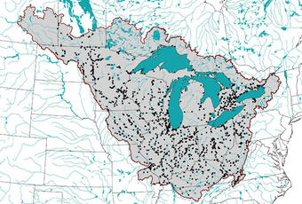
SPARROW phosphorus and nitrogen models are being developed for the entire Great Lakes Basin and the Upper Midwest part of the U.S., and the Red and Assiniboine River Basin, as part of a Binational project between the USGS and the International Joint Commission (IJC) and National Research Council (NRC) of Canada.
SPARROW (SPAtially Referenced Regression On Watershed attributes) models track the transport of phosphorus and nitrogen from local
inland watersheds to regional, coastal waters by explaining spatial patterns in stream water-quality conditions in relation to human activities and natural processes.
2002 Midcontinental SPARROW Models
SPARROW phosphorus and nitrogen models are being developed for the Midcontinental region of North America as part of a Binational project between the USGS and the International Joint Commission (IJC) and National Research Council (NRC) of Canada. These models cover the entire Great Lakes, Rainy–Lake of the Woods, Red River, Upper Mississippi, and Ohio River Basins.

This binational project focuses on:
- Developing a harmonized streamflow network and coverages of various environmental characteristics for the entire Basin;
- Estimating phosphorus and nitrogen loads/fluxes for monitoring sites throughout Canadian part of the Basin;
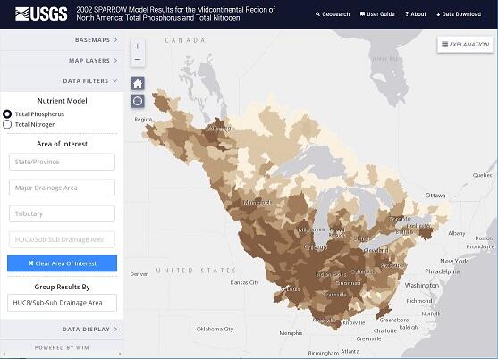
- Developing SPARROW models for total phosphorus and total nitrogen for the entire Midcontinental Region of North America, including the entire Great Lakes Basin, the Rainy–Lake of the Woods Basin, and the Upper Midwest part of the U.S.; and
- Using SPARROW models to describe the distribution of nutrient inputs to the Great Lakes and determine the relative importance of various nutrient sources.
An online mapper has been developed, which can be used by scientists and resource managers to easily access and visualize all model results at a variety of spatial scales anywhere in the Midcontinental Region of Canada and the United States.
This collaborative work builds upon the ongoing efforts of the Transboundary Hydrographic Data Harmonization Task Forces and a binational SPARROW modeling effort presently being conducted in the Red/Assiniboine River Basin.
Mid-Continental SPARROW Model contacts:
U.S. (USGS): Dale M. Robertson, Research Hydrologist, and David A. Saad, Hydrologist, USGS, Wisconsin Water Science Center
U.S. (IJC-U.S. Section): Michael Laitta, Washington, D.C.
Canada (IJC-Canadian Section): Wayne Jenkinson, Senior Engineering Advisor
NRC Canada: Ivana Vouk, Ocean, Coastal and River Engineering.
2002 Binational Red and Assiniboine River Basin SPARROW Models
SPARROW phosphorus and nitrogen models have been developed for the Red and Assiniboine River Basin as part of a Binational project between the USGS, the International Joint Commission (IJC), and the National Research Council (NRC) of Canada. This Binational water-quality-modeling effort is the first of its kind to make use of harmonized geospatial datasets and combined water-quality datasets from federal, provincial, and state jurisdictions in both the U.S. and Canada. These models will help address critical management needs, including identifying the allocation of nutrient sources by watershed, jurisdiction, and human activity; and determining the integrity of stream and river monitoring networks.
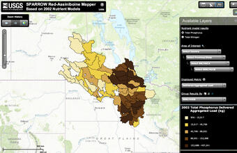
Online tools include a SPARROW Mapper and a possible future decision-making tool.
Learn more about the Binational Red Assiniboine River Basin Water Quality Modeling effort.
Red and Assininboine River Basin SPARROW Model contacts:
U.S. (USGS): Dale M. Robertson, Research Hydrologist, and David A. Saad, Hydrologist, USGS, Wisconsin Water Science Center
Canada (IJC-Canadian Section): Wayne Jenkinson, Senior Water Quality and Ecosystem Advisor, Ottawa, Canada (NRC)
Below are other science projects associated with this project.

SPARROW modeling: Estimating nutrient, sediment, and dissolved solids transport

SPARROW modeling: Great Lakes, Mississippi River, Ohio River, and Red River Basins

SPARROW nutrient modeling: Mississippi/Atchafalaya River Basin (MARB)
SPARROW phosphorus and nitrogen models are being developed for the entire Great Lakes Basin and the Upper Midwest part of the U.S., and the Red and Assiniboine River Basin, as part of a Binational project between the USGS and the International Joint Commission (IJC) and National Research Council (NRC) of Canada.
SPARROW (SPAtially Referenced Regression On Watershed attributes) models track the transport of phosphorus and nitrogen from local
inland watersheds to regional, coastal waters by explaining spatial patterns in stream water-quality conditions in relation to human activities and natural processes.
2002 Midcontinental SPARROW Models
SPARROW phosphorus and nitrogen models are being developed for the Midcontinental region of North America as part of a Binational project between the USGS and the International Joint Commission (IJC) and National Research Council (NRC) of Canada. These models cover the entire Great Lakes, Rainy–Lake of the Woods, Red River, Upper Mississippi, and Ohio River Basins.
This binational project focuses on:
- Developing a harmonized streamflow network and coverages of various environmental characteristics for the entire Basin;
- Estimating phosphorus and nitrogen loads/fluxes for monitoring sites throughout Canadian part of the Basin;
- Developing SPARROW models for total phosphorus and total nitrogen for the entire Midcontinental Region of North America, including the entire Great Lakes Basin, the Rainy–Lake of the Woods Basin, and the Upper Midwest part of the U.S.; and
- Using SPARROW models to describe the distribution of nutrient inputs to the Great Lakes and determine the relative importance of various nutrient sources.
An online mapper has been developed, which can be used by scientists and resource managers to easily access and visualize all model results at a variety of spatial scales anywhere in the Midcontinental Region of Canada and the United States.
This collaborative work builds upon the ongoing efforts of the Transboundary Hydrographic Data Harmonization Task Forces and a binational SPARROW modeling effort presently being conducted in the Red/Assiniboine River Basin.
Mid-Continental SPARROW Model contacts:
U.S. (USGS): Dale M. Robertson, Research Hydrologist, and David A. Saad, Hydrologist, USGS, Wisconsin Water Science Center
U.S. (IJC-U.S. Section): Michael Laitta, Washington, D.C.
Canada (IJC-Canadian Section): Wayne Jenkinson, Senior Engineering Advisor
NRC Canada: Ivana Vouk, Ocean, Coastal and River Engineering.
2002 Binational Red and Assiniboine River Basin SPARROW Models
SPARROW phosphorus and nitrogen models have been developed for the Red and Assiniboine River Basin as part of a Binational project between the USGS, the International Joint Commission (IJC), and the National Research Council (NRC) of Canada. This Binational water-quality-modeling effort is the first of its kind to make use of harmonized geospatial datasets and combined water-quality datasets from federal, provincial, and state jurisdictions in both the U.S. and Canada. These models will help address critical management needs, including identifying the allocation of nutrient sources by watershed, jurisdiction, and human activity; and determining the integrity of stream and river monitoring networks.
Online tools include a SPARROW Mapper and a possible future decision-making tool.
Learn more about the Binational Red Assiniboine River Basin Water Quality Modeling effort.
Red and Assininboine River Basin SPARROW Model contacts:
U.S. (USGS): Dale M. Robertson, Research Hydrologist, and David A. Saad, Hydrologist, USGS, Wisconsin Water Science Center
Canada (IJC-Canadian Section): Wayne Jenkinson, Senior Water Quality and Ecosystem Advisor, Ottawa, Canada (NRC)
Below are other science projects associated with this project.
SPARROW modeling: Estimating nutrient, sediment, and dissolved solids transport
SPARROW modeling: Great Lakes, Mississippi River, Ohio River, and Red River Basins