
November 2006 recorded extensive flooding across Western Washington. High flows transported large amounts of sediment and large wood, as shown in this photograph taken near USGS streamgage 12093500.
Images
Below are images associated with the Washington Water Science Center's science and staff. Images appear according to the year they were taken. To search, type a keyword or select a year from the dropdown menu. Or, click through the pages using the arrows at the bottom of the page.
Filter Total Items: 254

Large wood transported by flood waters
November 2006 recorded extensive flooding across Western Washington. High flows transported large amounts of sediment and large wood, as shown in this photograph taken near USGS streamgage 12093500.

Flood waters erode riverbank
In November 2006, flooding damaged infrastructure alongside several rivers in Western Washington. This photograph shows where Puyallup River eroded parts of the riverbank near USGS streamgage 12092000.
In November 2006, flooding damaged infrastructure alongside several rivers in Western Washington. This photograph shows where Puyallup River eroded parts of the riverbank near USGS streamgage 12092000.

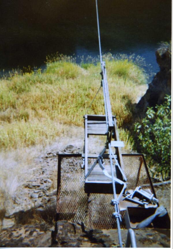
Hydrologic Technician Prepares for High Flow Measurement from a Cableway
Hydrologic Technician Prepares for High Flow Measurement from a CablewayHigh flows and floods affected several Western Washington rivers in November 2006. This photo shows a hydrologic technician preparing to measure the Puyallup River near Orting, WA from a cableway.

High Flow Cableway Measurement
A USGS hydrologic technician adjusts equipment while preparing to make a measurement from a cableway. Cableways provide technicians with a way to safely measure fast-flowing rivers.
A USGS hydrologic technician adjusts equipment while preparing to make a measurement from a cableway. Cableways provide technicians with a way to safely measure fast-flowing rivers.

Measuring High Flows on the Puyallup River
High flows coursed through rivers in Western Washington in November 2006. USGS Hydrologic Technicians worked hard to measure the streamflow, using a variety of methods including cableway measurements which allow safe transport over high flowing water.
High flows coursed through rivers in Western Washington in November 2006. USGS Hydrologic Technicians worked hard to measure the streamflow, using a variety of methods including cableway measurements which allow safe transport over high flowing water.

Puyallup River Flood, 2006
In November 2006, the Puyallup River overtopped its banks in several locations, including near USGS streamgage 12096500. Flood waters carried sediment and large wood.
In November 2006, the Puyallup River overtopped its banks in several locations, including near USGS streamgage 12096500. Flood waters carried sediment and large wood.
Historical cableway across NF John Day River, OR
Cableways allow USGS hydrologic technicians to cross fast-flowing and deep rivers to make measurements.
Cableways allow USGS hydrologic technicians to cross fast-flowing and deep rivers to make measurements.

Water quality sampling from a bridge
Hydrologic Technicians use bridge cranes and reels to collect water quality samples. Similar technology is still in use today.
Hydrologic Technicians use bridge cranes and reels to collect water quality samples. Similar technology is still in use today.

Columbia River Cableway
A cableway spanning the Columbia River allowed hydrologic technicians to traverse the steep basalt river banks. Pictured before the construction of Priest Rapids Dam, the cableway was located at USGS streamgage 12472800.
A cableway spanning the Columbia River allowed hydrologic technicians to traverse the steep basalt river banks. Pictured before the construction of Priest Rapids Dam, the cableway was located at USGS streamgage 12472800.

New Columbia River Cableway
Technicians installed a new cableway on the Columbia River below Priest Rapids Dam at USGS streamgage 12472800. Date unknown.
Technicians installed a new cableway on the Columbia River below Priest Rapids Dam at USGS streamgage 12472800. Date unknown.

Measuring a flood from cableway
USGS staff prepare to measure a flooding river from a cableway. The location is likely USGS streamgage 12472800 on the Columbia River below Priest Rapids Dam.
USGS staff prepare to measure a flooding river from a cableway. The location is likely USGS streamgage 12472800 on the Columbia River below Priest Rapids Dam.

Cableway measurement on Columbia River
The steep basalt banks of the Columbia River below Priest Rapids Dam at USGS streamgage 12472800 made for tricky streamflow measurements.
The steep basalt banks of the Columbia River below Priest Rapids Dam at USGS streamgage 12472800 made for tricky streamflow measurements.

Weir streamgage
A historical USGS streamgage measured flow through a small river in Washington State. The gagehouse on the right relied on the concrete weir to make flow measurements. The exact date and location are unknown.
A historical USGS streamgage measured flow through a small river in Washington State. The gagehouse on the right relied on the concrete weir to make flow measurements. The exact date and location are unknown.

USGS streamgage on small river in Washington State
USGS streamgage on small river in Washington StateA goose wades in front of a USGS streamgage. The staff plate (measuring stick) is visible in front of the small bridge. The exact date and location are unknown.
USGS streamgage on small river in Washington State
USGS streamgage on small river in Washington StateA goose wades in front of a USGS streamgage. The staff plate (measuring stick) is visible in front of the small bridge. The exact date and location are unknown.

Historical Gagehouse in Washington State
The USGS monitors streamflow in rivers across the nation year-round. Here, a technician makes notes at a gagehouse on a river in Washington State. The exact date and location are unknown.
The USGS monitors streamflow in rivers across the nation year-round. Here, a technician makes notes at a gagehouse on a river in Washington State. The exact date and location are unknown.

Central Washington historical streamgage
A USGS streamgage and cableway situated on a small river in central Washington State. The exact location and date are unknown.
A USGS streamgage and cableway situated on a small river in central Washington State. The exact location and date are unknown.

Streamgage and cableway installation - before/after
Streamgage and cableway installation - before/afterBefore/after photographs document the installation of a new USGS gagehouse and cableway in Washington State. The exact date and location are unknown.
Streamgage and cableway installation - before/after
Streamgage and cableway installation - before/afterBefore/after photographs document the installation of a new USGS gagehouse and cableway in Washington State. The exact date and location are unknown.

Engineered Log Jam
Engineered Log Jam on the lower river opposite the new Lower Klallam Tribe Fish Hatchery.
The Lower Elwha Klallam Tribe project creates salmon habitat on the lower Elwha River in preparation for dam removal and habitat restoration.
Engineered Log Jam on the lower river opposite the new Lower Klallam Tribe Fish Hatchery.
The Lower Elwha Klallam Tribe project creates salmon habitat on the lower Elwha River in preparation for dam removal and habitat restoration.

Diver with Anemone
USGS Diver Reg Reisenbichler observing a Fish Eating anemone.
USGS Diver Reg Reisenbichler observing a Fish Eating anemone.

Elwha River Dam
The 100 yr old, 108 ft tall Elwha Dam drawdown of water from Lake Aldwell reservoir began June 1, 2011 in preparation for Elwha Dam.
The 100 yr old, 108 ft tall Elwha Dam drawdown of water from Lake Aldwell reservoir began June 1, 2011 in preparation for Elwha Dam.

Diver Recording Data
USGS Diver Nancy Elder recording invertebrate data.
USGS Diver Nancy Elder recording invertebrate data.