U.S. flag

An official website of the United States government

Data

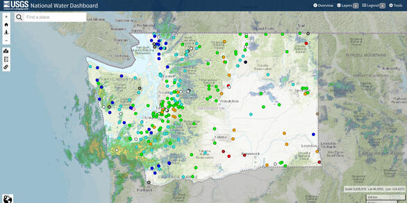
The USGS Washington Water Science Center currently operates over 380 data-collection sites in Washington.  The sites collect surface water, groundwater, water quality and meteorological data that are available in real time.  Current and historic data can be retrieved from the National Water Information System (NWIS) database and the National Water Dashboard.

Filter Total Items: 92

Spatial Data in Support of the Characterization of Water Resources near the Southeastern Part of Puget Sound, Washington

The data within this data release presents information used to characterize the groundwater-flow system and the development of a groundwater-flow model in the active model area. Conceptual and numerical models of groundwater flow were developed by the U.S. Geological Survey Washington Water Science Center, in close cooperation with 18 water-resource agencies and stakeholders, to assess the potenti

Water stargrass biomass and stream metabolism estimates on the Lower Yakima River (2018 - 2020)

This dataset provides information collected at three stream sites on the lower Yakima River in Washington State during 2018 to 2020 by the U.S. Geological Survey. Sample locations included the Yakima River at Prosser, WA (site ID, 12509489), the Yakima River at Kiona, WA (site ID, 12510500), and the Yakima River at Van Giesen bridge near Richland, WA (site ID, 12511800). Water stargrass biomass wa

Water Temperature Dynamics in the Quillayute River Basin, Washington, 2021 - 2023

The Quillayute River Basin in northwestern Washington consists of the Quillayute River and the river systems of its major tributaries, the Dickey, Sol Duc, and Bogachiel Rivers. With a drainage area of 629 square miles, the Quillayute River Basin provides important habitat for 23 distinct runs of anadromous steelhead and salmon, representing one of the largest and most productive watersheds on the

Channel Cross Sections of the Nooksack River near North Cedarville, WA, 2017-2021

This data release contains channel cross sections of the Nooksack River near North Cedarville, WA, collected during routine streamgaging and discharge measurement efforts at USGS streamgage 12210700. All cross sections were collected using an acoustic doppler current profiler (ADCP) from the downstream side of the Highway 542 bridge. Raw ADCP measurement data were processed using a combination of

GIS data for U.S. Geological Survey OFR 2005-1252, The Geologic Map of Seattle—A Progress Report

This data release contains the GIS data supporting U.S. Geological Survey Open-File Report (OFR) 2005-1252, "The Geologic Map of Seattle—A Progress Report," published in 2005 by Kathy Goetz Troost, Derek B. Booth, Aaron P. Wisher, and Scott A. Shimel (https://doi.org/10.3133/ofr20051252). The OFR was prepared for the 2005 Washington Hydrogeology Symposium and describes the status of geologic mappi

Stream heat budget model input and scripts for simulating groundwater and thermal equilibrium controls on annual paired air-water temperature signal transport in headwater streams

We investigated the relative importance of groundwater (GW) and other local heat budget processes on downstream annual stream temperature signal characteristics using deterministic heat budget model (HFLUX) scenarios within an idealized stream reach representative of mountainous forested conditions. The purpose of this data release is to provide additional supplemental information for a published

High and average water table estimates for Clover Creek watershed, Pierce County, Washington

The depths to a high and average water table below the land surface were estimated across the Clover Creek watershed in Pierce County, Washington. Groundwater model simulations provided initial estimates of water-table depths for the analysis. To provide optimized, data-driven estimates of these depths, a continuous bias correction surface was applied to model output according to differences betwe

Identifying post-reservoir construction periods for monotonic trend analysis at streamgages in the United States

The U.S. Geological Survey (USGS) Water Resources Mission Area (WMA) is working to address a need to understand where the Nation is experiencing water shortages or surpluses relative to the demand for water need by delivering routine assessments of water supply and demand and an understanding of the natural and human factors affecting the balance between supply and demand. A key part of these nati

Index of vulnerability for elevated nitrates in groundwater in the Puget Sound Basin, Washington, 2000–2019

This data release consists of the initial well input data for the logistic regression model, the conceptual well data for logistic mapping, the logistic mapping output data, the logistic mapping output vulnerability and vulnerability difference rasters, and supporting geographic information system (GIS) files for the study titled 'Index of Vulnerability for Elevated Nitrates in Groundwater in the

MODFLOW-NWT model to simulate the groundwater flow system at Puget Sound Naval Shipyard, Naval Base Kitsap, Bremerton, Washington

A three-dimensional groundwater flow model was developed in 1997 to evaluate the groundwater flow system at Puget Sound Naval Shipyard, Naval Base Kitsap, Bremerton, Washington (https://pubs.er.usgs.gov/publication/wri964147). In 2016, a regional groundwater flow model for the greater Kitsap Peninsula was developed (https://pubs.er.usgs.gov/publication/sir20165052). Using information from the 2016

Long-term monotonic trends in annual and monthly stream temperature metrics at multi-source monitoring locations in the United States

The U.S. Geological Survey (USGS) Water Resources Mission Area (WMA) is working to address a need to understand where the Nation is experiencing water shortages or surpluses relative to the demand for water need by delivering routine assessments of water supply and demand and an understanding of the natural and human factors affecting the balance between supply and demand. A key part of the Integr

Water Temperature Mapping of the Skykomish, Snoqualmie, and Middle Fork Snoqualmie Rivers, Washington—Longitudinal Stream Temperature Profiles, Significant Thermal Features, and Airborne Thermal Infrared and RGB Imagery Mosaics

The Skykomish, Snoqualmie, and Middle Fork Snoqualmie River Basins have historically provided critical spawning, rearing, and core habitat for several salmonid species. These salmonid species include natural populations of Chinook salmon (O. tshawytscha), steelhead trout (O. mykiss), and bull trout (Salvelinus confluentus)—listed as “Threatened” under the Endangered Species Act—as well as coho sal

Was this page helpful?