
USGS scientist Eric Grossman demonstrates the water-quality instruments, used during the tribal canoe journeys, at the Swinomish Tribal Community Center.
Images
Below are images associated with the Washington Water Science Center's science and staff. Images appear according to the year they were taken. To search, type a keyword or select a year from the dropdown menu. Or, click through the pages using the arrows at the bottom of the page.
Filter Total Items: 254

Water Quality Demo
USGS scientist Eric Grossman demonstrates the water-quality instruments, used during the tribal canoe journeys, at the Swinomish Tribal Community Center.

KOMO-TV Interview of Eric Grossman
USGS scientist Eric Grossman interviewed by KOMO-TV (ABC,Seattle) at the Swinomish Tribal Community Center.
USGS scientist Eric Grossman interviewed by KOMO-TV (ABC,Seattle) at the Swinomish Tribal Community Center.

KOMO-TV Interview of Eric Grossman
USGS scientist Eric Grossman interviewed by KOMO-TV (ABC,Seattle) at the Swinomish Tribal Community Center.
USGS scientist Eric Grossman interviewed by KOMO-TV (ABC,Seattle) at the Swinomish Tribal Community Center.

KOMO-TV Interview of Eric Grossman
USGS scientist Eric Grossman interviewed by KOMO-TV (ABC,Seattle) at the Swinomish Tribal Community Center.
USGS scientist Eric Grossman interviewed by KOMO-TV (ABC,Seattle) at the Swinomish Tribal Community Center.

Canoe Arriving at Swinomish
A canoe family arriving at the the beach at the Swinomish Tribal Community Center.
A canoe family arriving at the the beach at the Swinomish Tribal Community Center.

Canoe Arriving at Swinomish
A canoe family arriving at the the beach at the Swinomish Tribal Community Center.
A canoe family arriving at the the beach at the Swinomish Tribal Community Center.

KOMO-TV Reporter
Reporter Robert Santos of KOMO-TV, Seattle, reports live from the beach at the Swinomish Tribal Community Center.
Reporter Robert Santos of KOMO-TV, Seattle, reports live from the beach at the Swinomish Tribal Community Center.

Water Quality Demo
USGS scientist Eric Grossman demonstrates the water-quality instruments, used during the tribal canoe journeys, at the Swinomish Tribal Community Center.
USGS scientist Eric Grossman demonstrates the water-quality instruments, used during the tribal canoe journeys, at the Swinomish Tribal Community Center.

Canoe Arriving at Swinomish
A canoe family arriving at the beach at the Swinomish Tribal Community Center.
A canoe family arriving at the beach at the Swinomish Tribal Community Center.

KOMO-TV Interview of Eric Grossman
USGS scientist Eric Grossman interviewed by KOMO-TV (ABC,Seattle) at the Swinomish Tribal Community Center.
USGS scientist Eric Grossman interviewed by KOMO-TV (ABC,Seattle) at the Swinomish Tribal Community Center.

Canoe Arriving at Swinomish
A canoe family arriving and requesting permission from Brian Cladoosby, Swinomish Tribe chairman, to
come ashore at the the beach at the Swinomish Tribal Community Center
A canoe family arriving and requesting permission from Brian Cladoosby, Swinomish Tribe chairman, to
come ashore at the the beach at the Swinomish Tribal Community Center

Water Quality Demo
USGS scientist Eric Grossman demonstrates the water-quality instruments, used during the tribal canoe journeys, at the Swinomish Tribal Community Center.
USGS scientist Eric Grossman demonstrates the water-quality instruments, used during the tribal canoe journeys, at the Swinomish Tribal Community Center.

KOMO-TV Truck
KOMO-TV (ABC, Seattle) satellite truck parked near the beach at the Swinomish Tribal Community Center
KOMO-TV (ABC, Seattle) satellite truck parked near the beach at the Swinomish Tribal Community Center

Water Quality Demo
USGS scientist Eric Grossman demonstrates the water-quality instruments, used during the tribal canoe journeys, at the Swinomish Tribal Community Center.
USGS scientist Eric Grossman demonstrates the water-quality instruments, used during the tribal canoe journeys, at the Swinomish Tribal Community Center.

Stormwater Runoff in Rapid City, SD
Stormwater runoff following a May 2008 storm event in the Arrowhead drainage basin in Rapid City, SD. Runoff from this drainage discharges into Rapid Creek. Stormwater runoff from urbanized lands is known to harm surface-water resources by increasing stream velocities, destroying natural habitat, and increasing pollutant loads in the receiving waters.
Stormwater runoff following a May 2008 storm event in the Arrowhead drainage basin in Rapid City, SD. Runoff from this drainage discharges into Rapid Creek. Stormwater runoff from urbanized lands is known to harm surface-water resources by increasing stream velocities, destroying natural habitat, and increasing pollutant loads in the receiving waters.
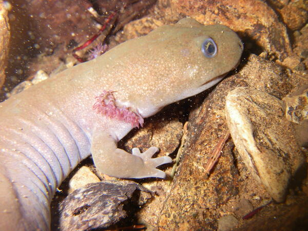
Salamander
A juvenile (neotone) salamander perches on a rock in a Pacific Northwest stream.
A juvenile (neotone) salamander perches on a rock in a Pacific Northwest stream.

Crest Gage Measurement of High Flows
Crest gages record high flows. In this case, pieces of cork floating in a tube record the highest level that water reached during a storm event. A technician records the level with a tape measure.
Crest gages record high flows. In this case, pieces of cork floating in a tube record the highest level that water reached during a storm event. A technician records the level with a tape measure.