
Drinking Water Quality
Drinking Water Quality
We monitor and conduct research to determine the source and extent of water quality contamination where it is identified as well as identifying potential impacts to clean and plentiful drinking water to provide water purveyors and managers information that helps them protect and restore these valuable resources.
Filter Total Items: 15
Carbon in Urban River Biogeochemistry Project
The Issue: In aquatic ecosystems, dissolved organic carbon represents the largest flux of carbon in streams and it is a primary energy source in aquatic food webs. There is limited understanding of how human activities related to urban development influence the timing and scale of carbon cycling in aquatic ecosystems. How USGS will help: The USGS is working with university partners to assess how...

Bolt Creek Wildfire Sediment Runoff and Water Quality
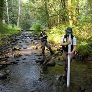
The Issue: Scientists and water-resource managers recognize the increasing impact of wildfires on water supply in the western U.S. The increasing frequency and severity of wildfires are linked to changes in snowpack, warmer temperatures, and drought. Sedimentation following wildfire can impact aquatic habitat, reservoir storage capacity, water quality, and thus public drinking water supplies...
Stormwater Action Monitoring (SAM)
The issue: Stormwater runoff often carries pollutants that degrade water quality in receiving waters. A regional-scale monitoring program is necessary to objectively measure and track progress in reducing stormwater impacts on environmental health. How USGS will help: Scientists from the U.S. Geological Survey (USGS) are monitoring water quality and watershed health for urban and urbanizing areas...
Simulated groundwater flow paths and travel times near Joint Base Lewis–McChord, Washington
The Issue: Past activities at Joint Base Lewis–McChord (JBLM)—located in west-central Washington—resulted in releases of hazardous waste and contaminants to the environment, and the most recent chemical of concern is per- and polyfluoroalkyl substances (PFAS). PFAS can enter groundwater and travel through the subsurface. Water-resource managers need to understand where groundwater flows in order...
Improving the understanding of groundwater hydrology near the Yakima Training Center, Washington
The Issue: The Yakima Training Center (YTC) is a military training installation located in south-central Washington. Recent sampling of groundwater wells on and off the base has detected per- and polyfluoroalkyl substances (PFAS)—man-made chemicals that, in some areas, exceed State or Federal drinking-water standards. The local geology is highly complex, featuring folded and faulted bedrock...

Keyport Groundwater Model
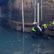
The Issue: Chlorinated volatile organic compounds have impacted groundwater beneath a former 9-acre landfill at OU 1 of the Naval Base Kitsap Keyport, Washington. The landfill is adjacent to tidal flats that are an extension of Liberty and Dogfish Bays and was the primary disposal area for domestic and industrial waste generated by NBK Keyport from the 1930s through 1973. The Navy needs a detailed...

Central Columbia Plateau - Yakima River Basin
The issue: Agriculture and irrigation are major forces in Central Washington. Intensive land and water management practices may lead to water quality issues. In the Central Columbia Plateau and Yakima River Basin (CCYK), water quality issues include high nutrient loading resulting in eutrophication, elevated concentrations of water-soluble pesticides, and elevated concentrations of organochlorine...

Puget Sound Basin NAWQA
The Puget Sound Basin (PUGT) study unit of the National Water Quality Assessment (NAWQA) program encompasses a 13,700-square-mile area that drains to Puget Sound and adjacent marine waters. Included in this region are all or part of 13 counties in western Washington, as well as the headwaters of the Skagit River and part of the Nooksack River in British Columbia, Canada. The Puget Sound Basin...

Yakima Nitrates
The Issue: Links between nitrate application to the land surface and measured nitrate concentrations in groundwater or surface water are poorly understood in the Yakima River basin due to the variety of potential nitrate sources. Fertilizer-intensive irrigated agriculture has been prevalent in the basin for decades, and since 1994 the growth of dairy operations has resulted in numerous liquid...

Uranium in Groundwater
The Issue: Groundwater monitoring in northeastern Washington State has shown elevated levels of naturally occurring uranium in several community water systems and in private wells. A better understanding of the occurrence of uranium in groundwater along with outreach products that communicate the risk to area residents are important in order to reduce uranium exposure, protect from the toxic...

DOH Nitrates
Ground water is a significant source of drinking water in Washington State, and keeping it free of contamination is important for public health. Public supply wells are frequently tested for nitrate concentrations, but private wells are tested only when they are drilled. This limits information about the potential exposure to elevated nitrate concentrations in private wells. To help the Washington...

San Juan County
Aquifers of the San Juan Islands, which are the principal source of fresh water, are commonly intruded by seawater at near-shoreline locations (less than one mile from the shore). Because the demand for ground water has escalated in recent years due to population growth and is expected to continue, the progression of seawater intrusion and areas most susceptible to future seawater intrusion must...