
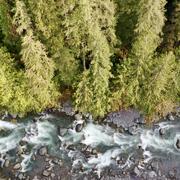
Floods
Floods
In addition to the flood warning information that is provided by real-time USGS streamgages across the state, we conduct monitoring and research that allows us to improve our understanding and prediction of the magnitude and frequency of floods in Wasington. This may include locating and measuring high-water marks and related post-flood data soon after particularly large flood events, or developing computer models to simulate possible floods under changing land use or climate conditions.
Filter Total Items: 14
Watersheds and Fluvial Systems Team
The Watersheds and Fluvial Systems Team at the Washington Water Science Center provides reliable science to understand how watersheds, rivers, and streams function—and how they respond to a changing world. We aim to build partnerships that foster informed decision-making and effective resource management throughout the Pacific Northwest region and across the U.S.
Testing non-contact discharge measurement methods in the Nooksack River
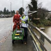
The Issue: The North Cedarville streamgage on the Nooksack River (USGS 12210700) is critical for flood monitoring and hazard assessments. However, making discharge measurements at high flows, which are necessary to maintain an accurate stage-discharge relation at this dynamic site, is complicated by transport of woody debris and difficulties detecting the bed using traditional acoustic doppler...
Green River Sediment Monitoring
The Issue: Management efforts on the lower Green River to reduce flood hazards and improve habitat conditions are inherently interconnected with sediment transport and channel change dynamics. Those dynamics are, in turn, driven by a mix of interacting geologic, anthropogenic, and hydrologic factors. However, there have been no recent watershed-scale analyses of sediment dynamics in the Green...

Hoh geomorphology
The Issue: Glaciers in the Hoh River watershed are expected to largely disappear by 2050, while flooding is expected to become more intense. Understanding if or how this will impact sediment transport and channel change in the watershed is relevant for salmon habitat, restoration efforts, and flood hazard management. However, there is relatively little information about historical channel...

Nooksack geomorphology
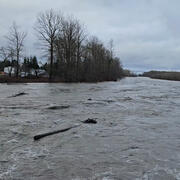
The Issue: Changes in channel geometry in the Nooksack River can reduce flood conveyance capacity, and so increase local flood hazards. Near Everson, WA, sand and gravel accumulations have increased the likelihood that major floods will spill overbank, sending water north over a low drainage divide where it may cause substantial damage to communities in both Washington and British Columbia. Major...

Hydrogeologic Framework for the Duwamish River Valley to the Lake Washington Ship Canal, Washington
The Issue: King County has over 30 miles of coastline on the Puget Sound where coastal sea level rise and high tides can cause flooding. Many coastal areas have low elevations and are prone to flooding during high tides, extreme rainfall, and high streamflow. In addition, groundwater inundation—localized coastal flooding due to a rise of the groundwater table with global sea-level rise—may...

Channel Change and Sediment Transport in the Puyallup River Watershed
The Issue: Sediment loads in the Puyallup River and its major tributaries, the White River and Carbon River, are high and river channels are dynamic. While there is a relatively rich history of sediment transport and channel change studies in the Puyallup River and its tributaries, there has not been an integrated assessment of channel-elevation trends in nearly a decade. This lack of up-to-date...

Analysis of USGS Surface Water Monitoring Networks
The issue: National interests in water information are important but challenging to incorporate into planning and operation of a monitoring network driven by local information needs. These interests include an understanding of the spatial variability in water availability across the United States, anthro-physical factors including climate and land use that affect water availability, and federal...

FEMA High Water Marks - Western Washington Flood, January 2009
The Issue: Significant flooding occurred throughout western Washington on January 7 and 8, 2009. As part of its Hazard Mitigation effort, the Federal Emergency Management Agency (FEMA) Region X needs documentation on the extent of flooding for verifying Preliminary Digital Flood Insurance Rate Maps (DFIRMs) and corresponding Flood Insurance Studies (FIS) that have been recently completed, or are...
FEMA Technical Support
9722-DRE00 - FEMA Technical Support, Pre-Declaration, January 2009 Floods - Completed FY2009 A wide plume of warm moist air streaming in from west of Hawaii caused widespread rainfall throughout western Washington in early January 2009. National Weather Service flood stages were exceeded in many different basins, most of which drain from the west side of the Cascade Range. Flows at four long-term...

Puget Hazards
Nationally, the USGS monitors and assesses geologic and hydrologic natural hazards. In the Puget Sound Basin, common hazards that also can cause damage include earthquakes and floods. Other hazards in the region that cause less damage or happen less frequently include landslides, debris flows, tsunamis, and volcanic eruptions. Although much is known about these natural hazards, mitigation and...

Honduras Flood Mapping
Honduras is currently (2001) rebuilding its housing and infrastructure that was destroyed by Hurricane Mitch. To plan responsibly and minimize damage during future floods, the Honduran government needs reliable maps of the areas and depth of inundation by the 50-year flood, the design flood chosen for this project. A systematic method for defining areas and depths of inundation is needed that can...