



Movements and Migratory Stopovers Among Birds in the Western U.S. Using Networked Weather Radar and Motus Wildlife Tracking Data
USGS scientists from the Wetland and Aquatic Research Center and the Western Ecological Research Center are collaborating to synthesize data on migratory bird use of Bureau of Land Management lands in the western U.S. to support permitting decisions.
The Science Issue and Relevance: The Bureau of Land Management (BLM) manages about 245–247 million acres of federal public land—roughly one-tenth of the U.S. land base. The vast majority of this land is in the western U.S. where BLM is charged with balancing resource extraction, recreation, conservation, and public safety under a statutory mandate to sustain the health and productivity of these lands for present and future generations. The USGS is assisting BLM by providing rigorous, unbiased science support to inform Federal land management.
Wildlife movement and space use information can support permitting and environmental review for the protection of U.S. species. Presently, there is little information on timing, habitat use, and large-scale spatial distributions of landbirds during migration in areas that overlap with the extensive BLM lands throughout the western U.S. To inform permitting and management decisions, the BLM could benefit from readily available, comprehensive, and informative data about distribution and movements of migratory bird species throughout their managed lands in the western U.S.
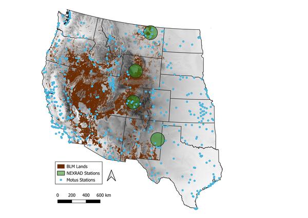
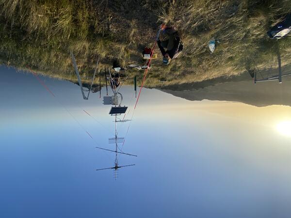
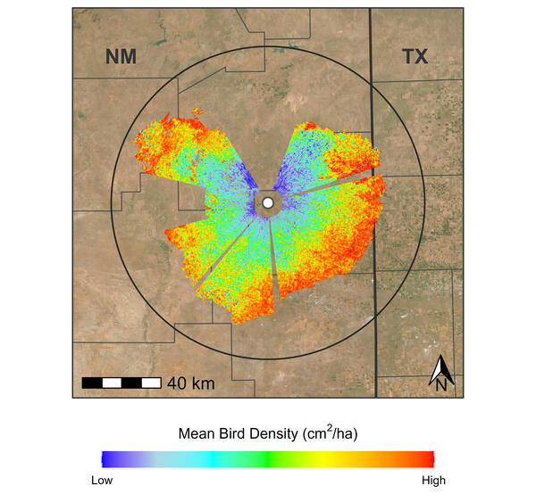
Methodology for Addressing the Issue: USGS scientists with experience studying the movements and distributions of birds using novel techniques have teamed up to synthesize and make available to BLM data on migratory bird use of western U.S. BLM lands based on two independent sources: the National Weather Service’s network of Next Generation Weather Surveillance Radars (NEXRAD) and the Motus Wildlife Tracking Network. Data from NEXRAD provides information on the largescale distribution and habitat use of birds as they stop to rest and refuel during their migratory journeys. Data from the Motus Wildlife Tracking Network provides finer-scale information on the movements and locations of known individuals as they move across the landscape. This project will (1) screen and process available NEXRAD data for four radars in Montana, Wyoming, Colorado, and New Mexico during spring and fall of 2020–2025 and (2) concatenate and summarize available species-specific Motus tracking data through fall 2025.
Future Steps: USGS scientists are working to produce spatially explicit data of bird distributions and movements across a large area to support permitting decisions on public lands. This information could be used to readily identify areas that have reduced overlap with birds during migration, allowing for improved efficiency during National Environmental Policy Act (NEPA) review. The spatially explicit NEXRAD and telemetry layers will be consolidated into a decision support tool being developed by the USGS that can assist BLM with project and land-use planning on federal lands.
USGS scientists from the Wetland and Aquatic Research Center and the Western Ecological Research Center are collaborating to synthesize data on migratory bird use of Bureau of Land Management lands in the western U.S. to support permitting decisions.
The Science Issue and Relevance: The Bureau of Land Management (BLM) manages about 245–247 million acres of federal public land—roughly one-tenth of the U.S. land base. The vast majority of this land is in the western U.S. where BLM is charged with balancing resource extraction, recreation, conservation, and public safety under a statutory mandate to sustain the health and productivity of these lands for present and future generations. The USGS is assisting BLM by providing rigorous, unbiased science support to inform Federal land management.
Wildlife movement and space use information can support permitting and environmental review for the protection of U.S. species. Presently, there is little information on timing, habitat use, and large-scale spatial distributions of landbirds during migration in areas that overlap with the extensive BLM lands throughout the western U.S. To inform permitting and management decisions, the BLM could benefit from readily available, comprehensive, and informative data about distribution and movements of migratory bird species throughout their managed lands in the western U.S.
Methodology for Addressing the Issue: USGS scientists with experience studying the movements and distributions of birds using novel techniques have teamed up to synthesize and make available to BLM data on migratory bird use of western U.S. BLM lands based on two independent sources: the National Weather Service’s network of Next Generation Weather Surveillance Radars (NEXRAD) and the Motus Wildlife Tracking Network. Data from NEXRAD provides information on the largescale distribution and habitat use of birds as they stop to rest and refuel during their migratory journeys. Data from the Motus Wildlife Tracking Network provides finer-scale information on the movements and locations of known individuals as they move across the landscape. This project will (1) screen and process available NEXRAD data for four radars in Montana, Wyoming, Colorado, and New Mexico during spring and fall of 2020–2025 and (2) concatenate and summarize available species-specific Motus tracking data through fall 2025.
Future Steps: USGS scientists are working to produce spatially explicit data of bird distributions and movements across a large area to support permitting decisions on public lands. This information could be used to readily identify areas that have reduced overlap with birds during migration, allowing for improved efficiency during National Environmental Policy Act (NEPA) review. The spatially explicit NEXRAD and telemetry layers will be consolidated into a decision support tool being developed by the USGS that can assist BLM with project and land-use planning on federal lands.