Herring River Restoration Project Groundbreaking Event
Herring River Restoration Project Groundbreaking EventThe USGS celebrating the groundbreaking of the Herring River restoration!

Official websites use .gov
A .gov website belongs to an official government organization in the United States.
Secure .gov websites use HTTPS
A lock () or https:// means you’ve safely connected to the .gov website. Share sensitive information only on official, secure websites.
The Herring River restoration is now underway. For nearly a decade, the USGS has conducted blue carbon research to support this restoration project and determine the carbon cycle response to rising sea levels under both restored and diked wetland scenarios.
After 20 years of planning and research by a collaborative group of federal, state, and local organizations, restoration of the Herring River in Wellfleet, Massachusetts is now underway.
The USGS has been an active collaborator in the Herring River Restoration Project since 2015. Our scientists have been working to assess how the restoration will affect the ecosystem and greenhouse gas emissions in Herring River. Results show that restoring tidal flow in impounded coastal wetlands can enhance elevation resilience and climate change mitigation benefits. Specific fieldwork has included using eddy flux towers to continuously measure carbon dioxide and methane emissions, measuring soil organic carbon storage, evaluating dissolved fluxes of carbon, and monitoring water table depth and salinity across the impounded wetland.

The USGS is also modeling carbon cycle response to sea-level rise in the 21st century for both restored and degraded wetlands to better understand the fate of such systems if they are not restored and sea-level rise continues to accelerate. Models, supported by field research, include hydrology, vegetation change, soil carbon and elevation change, and methane emissions.
Through this work, USGS is working to complete a total greenhouse gas accounting assessment for the restoration and has published scientific papers about greenhouse gas emissions and the climate change mitigation effects of restoring tidal flow to impounded coastal wetlands.
Quantifying and maximizing the climate change mitigation value of the restoration has been a compelling project benefit and helped garner support for the project.


On March 31, federal and state officials, project partners, and members of the community came together to celebrate the start of construction of the Chequessett Neck bridge, the first and largest infrastructure component of the Herring River Restoration Project.
Speakers at the event included Congressman Bill Keating, Senator Edward Markey represented by State Director James Cantwell, Senator Elizabeth Warren represented by Regional Director Caleb White; State Senator Julian Cyr; and District Representative Sarah Peake; as well as representatives from the U.S. National Park Service, Cape Cod National Seashore; Massachusetts Division of Ecological Restoration; National Oceanic and Atmospheric Administration; U.S. Department of Agriculture, Natural Resource Conservation Service; Massachusetts Executive Office of Energy and Environmental Affairs; U.S. Fish and Wildlife Service; and the local non-profit Friends of Herring River.


Each speaker discussed the value and importance of the Herring River Restoration Project and applauded the collaborative effort that resulted in this progress.
“Today’s groundbreaking is the culmination of years and years of work by many people – and it stands as a true testament to the benefits of a strong local, state, and federal partnership,” said Congressman Bill Keating. “This historic investment into 1,100 acres of tidal saltmarsh will reverse the ecological degradation of the past century and revive what was once the most productive saltmarsh system in the northeast through the region’s largest ever tidal restoration project.”
Phase one of the restoration will restore 570 acres of degraded marsh in the Herring River estuary and include the water control infrastructure needed to restore the full 890 acres. The tidally restrictive dike at the mouth of the river is being replaced with a bridge that will restore tidal exchange between Herring River and Wellfleet Harbor. Phase two will focus on protecting low-lying roads and structures in Wellfleet and Truro, Massachusetts from rising sea levels. Tide gates built into the bridge will be opened gradually over several years so scientists can monitor the changing conditions closely.

The 1,100-acre Herring River estuary was once one of the largest salt marsh systems in the Northeast, as well as one of the most productive herring runs. Restoring tidal flow will help the river return to its former thriving condition before the dike was built. This can improve water quality, restore native vegetation and shellfish harvesting, improve habitat for wildlife, and enhance climate change mitigation.
The Herring River Restoration Project is recognized as a nationally significant model for using science to inform management decisions. The USGS and other partners will continue to study blue carbon, tidal hydrology, water quality, sediment transport, vegetation changes, and other variables to evaluate the effects of the tidal restoration and help inform next steps.


The USGS celebrating the groundbreaking of the Herring River restoration!
The USGS celebrating the groundbreaking of the Herring River restoration!
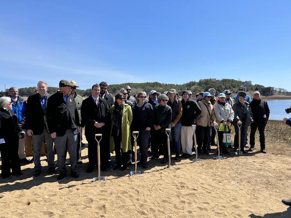
State and Federal officials joined partners involved in the Herring River Restoration Project for a group photo at the groundbreaking event at Chequessett Neck bridge in Wellfleet, Massachusetts.
State and Federal officials joined partners involved in the Herring River Restoration Project for a group photo at the groundbreaking event at Chequessett Neck bridge in Wellfleet, Massachusetts.

State and Federal officials joined partners involved in the Herring River Restoration Project for a group photo at the groundbreaking event at Chequessett Neck bridge in Wellfleet, Massachusetts.
State and Federal officials joined partners involved in the Herring River Restoration Project for a group photo at the groundbreaking event at Chequessett Neck bridge in Wellfleet, Massachusetts.

State and Federal officials joined partners involved in the Herring River Restoration Project for a group photo at the groundbreaking event at Chequessett Neck bridge in Wellfleet, Massachusetts.
State and Federal officials joined partners involved in the Herring River Restoration Project for a group photo at the groundbreaking event at Chequessett Neck bridge in Wellfleet, Massachusetts.

A sign at the Herring River Restoration Project Groundbreaking Event detailing restoration plans.
A sign at the Herring River Restoration Project Groundbreaking Event detailing restoration plans.

The USGS celebrating the groundbreaking of the Herring River restoration!
The USGS celebrating the groundbreaking of the Herring River restoration!

The Chequessett Neck bridge in Wellfleet, Massachusetts, the construction site of the first and largest infrastructure component of the Herring River Restoration Project.
The Chequessett Neck bridge in Wellfleet, Massachusetts, the construction site of the first and largest infrastructure component of the Herring River Restoration Project.

Marcel Belaval (Deputy Director, USGS New England Water Science Center), Rob Thieler (Center Director, USGS Woods Hole Coastal and Marine Science Center), Brian Carlstrom (Superintendent, Cape Cod National Seashore, U.S.
Marcel Belaval (Deputy Director, USGS New England Water Science Center), Rob Thieler (Center Director, USGS Woods Hole Coastal and Marine Science Center), Brian Carlstrom (Superintendent, Cape Cod National Seashore, U.S.

Marcel Belaval (Deputy Director, USGS New England Water Science Center), Rob Thieler (Center Director, USGS Woods Hole Coastal and Marine Science Center), Brian Carlstrom (Superintendent, Cape Cod National Seashore, U.S.
Marcel Belaval (Deputy Director, USGS New England Water Science Center), Rob Thieler (Center Director, USGS Woods Hole Coastal and Marine Science Center), Brian Carlstrom (Superintendent, Cape Cod National Seashore, U.S.

Kevin Kroeger, Marcel Belaval, and Rob Thieler of the U.S. Geological Survey talking with other collaborators involved in the Herring River Restoration Project.
Kevin Kroeger, Marcel Belaval, and Rob Thieler of the U.S. Geological Survey talking with other collaborators involved in the Herring River Restoration Project.

Kevin Kroeger, Marcel Belaval, and Rob Thieler of the U.S. Geological Survey talking with other collaborators involved in the Herring River Restoration Project.
Kevin Kroeger, Marcel Belaval, and Rob Thieler of the U.S. Geological Survey talking with other collaborators involved in the Herring River Restoration Project.

Kevin Kroeger, Research Chemist with the U.S. Geological Survey, Woods Hole Coastal and Marine Science Center, talking about blue carbon research with Congressman Bill Keating at the Herring River Restoration Project groundbreaking event.
Kevin Kroeger, Research Chemist with the U.S. Geological Survey, Woods Hole Coastal and Marine Science Center, talking about blue carbon research with Congressman Bill Keating at the Herring River Restoration Project groundbreaking event.

Meagan Eagle, Research Physical Scientist with the U.S. Geological Survey, Woods Hole Coastal and Marine Science Center, talking about USGS contributions to the Herring River Restoration Project with Congressman Bill Keating at the groundbreaking event.
Meagan Eagle, Research Physical Scientist with the U.S. Geological Survey, Woods Hole Coastal and Marine Science Center, talking about USGS contributions to the Herring River Restoration Project with Congressman Bill Keating at the groundbreaking event.

Rob Thieler, Meagan Eagle, and Sophie Kuhl of the U.S. Geological Survey, Woods Hole Coastal and Marine Science Center posing with the “Salt Marshes: A Carbon Bank in Our Backyard” sign near the Herring River.
Rob Thieler, Meagan Eagle, and Sophie Kuhl of the U.S. Geological Survey, Woods Hole Coastal and Marine Science Center posing with the “Salt Marshes: A Carbon Bank in Our Backyard” sign near the Herring River.

The USGS attendees of the Herring River Restoration Project groundbreaking event standing proudly next to a sign detailing the project.
The USGS attendees of the Herring River Restoration Project groundbreaking event standing proudly next to a sign detailing the project.
The USGS celebrating the groundbreaking of the Herring River restoration!
The USGS celebrating the groundbreaking of the Herring River restoration!
State and Federal officials joined partners involved in the Herring River Restoration Project for a group photo at the groundbreaking event at Chequessett Neck bridge in Wellfleet, Massachusetts.
State and Federal officials joined partners involved in the Herring River Restoration Project for a group photo at the groundbreaking event at Chequessett Neck bridge in Wellfleet, Massachusetts.
State and Federal officials joined partners involved in the Herring River Restoration Project for a group photo at the groundbreaking event at Chequessett Neck bridge in Wellfleet, Massachusetts.
State and Federal officials joined partners involved in the Herring River Restoration Project for a group photo at the groundbreaking event at Chequessett Neck bridge in Wellfleet, Massachusetts.
State and Federal officials joined partners involved in the Herring River Restoration Project for a group photo at the groundbreaking event at Chequessett Neck bridge in Wellfleet, Massachusetts.
State and Federal officials joined partners involved in the Herring River Restoration Project for a group photo at the groundbreaking event at Chequessett Neck bridge in Wellfleet, Massachusetts.
A sign at the Herring River Restoration Project Groundbreaking Event detailing restoration plans.
A sign at the Herring River Restoration Project Groundbreaking Event detailing restoration plans.
The USGS celebrating the groundbreaking of the Herring River restoration!
The USGS celebrating the groundbreaking of the Herring River restoration!
The Chequessett Neck bridge in Wellfleet, Massachusetts, the construction site of the first and largest infrastructure component of the Herring River Restoration Project.
The Chequessett Neck bridge in Wellfleet, Massachusetts, the construction site of the first and largest infrastructure component of the Herring River Restoration Project.
Marcel Belaval (Deputy Director, USGS New England Water Science Center), Rob Thieler (Center Director, USGS Woods Hole Coastal and Marine Science Center), Brian Carlstrom (Superintendent, Cape Cod National Seashore, U.S.
Marcel Belaval (Deputy Director, USGS New England Water Science Center), Rob Thieler (Center Director, USGS Woods Hole Coastal and Marine Science Center), Brian Carlstrom (Superintendent, Cape Cod National Seashore, U.S.
Marcel Belaval (Deputy Director, USGS New England Water Science Center), Rob Thieler (Center Director, USGS Woods Hole Coastal and Marine Science Center), Brian Carlstrom (Superintendent, Cape Cod National Seashore, U.S.
Marcel Belaval (Deputy Director, USGS New England Water Science Center), Rob Thieler (Center Director, USGS Woods Hole Coastal and Marine Science Center), Brian Carlstrom (Superintendent, Cape Cod National Seashore, U.S.
Kevin Kroeger, Marcel Belaval, and Rob Thieler of the U.S. Geological Survey talking with other collaborators involved in the Herring River Restoration Project.
Kevin Kroeger, Marcel Belaval, and Rob Thieler of the U.S. Geological Survey talking with other collaborators involved in the Herring River Restoration Project.
Kevin Kroeger, Marcel Belaval, and Rob Thieler of the U.S. Geological Survey talking with other collaborators involved in the Herring River Restoration Project.
Kevin Kroeger, Marcel Belaval, and Rob Thieler of the U.S. Geological Survey talking with other collaborators involved in the Herring River Restoration Project.
Kevin Kroeger, Research Chemist with the U.S. Geological Survey, Woods Hole Coastal and Marine Science Center, talking about blue carbon research with Congressman Bill Keating at the Herring River Restoration Project groundbreaking event.
Kevin Kroeger, Research Chemist with the U.S. Geological Survey, Woods Hole Coastal and Marine Science Center, talking about blue carbon research with Congressman Bill Keating at the Herring River Restoration Project groundbreaking event.
Meagan Eagle, Research Physical Scientist with the U.S. Geological Survey, Woods Hole Coastal and Marine Science Center, talking about USGS contributions to the Herring River Restoration Project with Congressman Bill Keating at the groundbreaking event.
Meagan Eagle, Research Physical Scientist with the U.S. Geological Survey, Woods Hole Coastal and Marine Science Center, talking about USGS contributions to the Herring River Restoration Project with Congressman Bill Keating at the groundbreaking event.
Rob Thieler, Meagan Eagle, and Sophie Kuhl of the U.S. Geological Survey, Woods Hole Coastal and Marine Science Center posing with the “Salt Marshes: A Carbon Bank in Our Backyard” sign near the Herring River.
Rob Thieler, Meagan Eagle, and Sophie Kuhl of the U.S. Geological Survey, Woods Hole Coastal and Marine Science Center posing with the “Salt Marshes: A Carbon Bank in Our Backyard” sign near the Herring River.
The USGS attendees of the Herring River Restoration Project groundbreaking event standing proudly next to a sign detailing the project.
The USGS attendees of the Herring River Restoration Project groundbreaking event standing proudly next to a sign detailing the project.