
USGS Coastal Landscape Change Products Help the U.S. Department of Defense Safeguard Military Infrastructure Along the Coast
The U.S. Department of Defense is supporting the geographic expansion of the USGS Coastal Change Likelihood and Coastal Landscape Response assessments. These assessments are critical to understanding future coastal landscape change that could impact military installations, sites, and infrastructure along the U.S. Atlantic and Gulf Coasts.
Our coasts are dynamic, continually changing in response to extreme weather events, high tide flooding, and coastal erosion. This landscape change can threaten important infrastructure along the coast, including structures important to our national security and public safety.
Each hurricane season, the U.S. Atlantic and Gulf Coasts generally endure a series of storms of varying intensities, where heavy rainfall, high winds, and increased water levels cause significant coastal change and pose risks to lives, military installations, defense communities, and the critical infrastructure assets and utilities on which U.S. Department of Defense missions rely. In the 2024 hurricane season alone, we saw a total of 18 named storms—resulting in \$182.7 billion in damages1.
To safeguard national security and public safety along our coastlines, preparedness is of paramount importance. USGS landscape change maps provide key answers to ‘where’ and ‘when’ questions regarding coastal change trends and environmental conditions necessary for effective decision making.

The Department of Defense partnered with the USGS to better understand future coastal landscape changes that are and will continue to impact military installations, defense access roads, and Sentinel Landscapes along the U.S. Atlantic and Gulf Coasts. The Department of Defense requires this knowledge to meet statutory requirements in Title 10, U.S. Code. Understanding the location and timing of these changes and resulting impacts (e.g., inundation or erosion), enables the development of proactive strategies to protect assets, investments, and resources that ensure the prosperity of the Nation and its citizens.
The USGS Coastal Change Likelihood and Coastal Landscape Response assessments address the probability of our coasts to resist change or transform due to coastal hazards caused by extreme storms and/or long-term sea level change.
Assessment outcomes can be used in conjunction with other products or tools used in installation planning and design, such as the Department of Defense Extreme Conditions Assessment Tool (DECAT) and the Department of Defense Regional Sea Level (DRSL) Database. Together, these products can highlight vulnerable areas, where resources can be prioritized to ensure installation resilience, which mitigation measures are most effective for a given location, areas that may be naturally more resilient or resistant to coastal change, and what hazards are of highest concern.
This information will support both near- and long-term Department of Defense planning objectives, helping them determine whether to adapt in place, change a military mission, or relocate due to extreme weather and coastal changes.

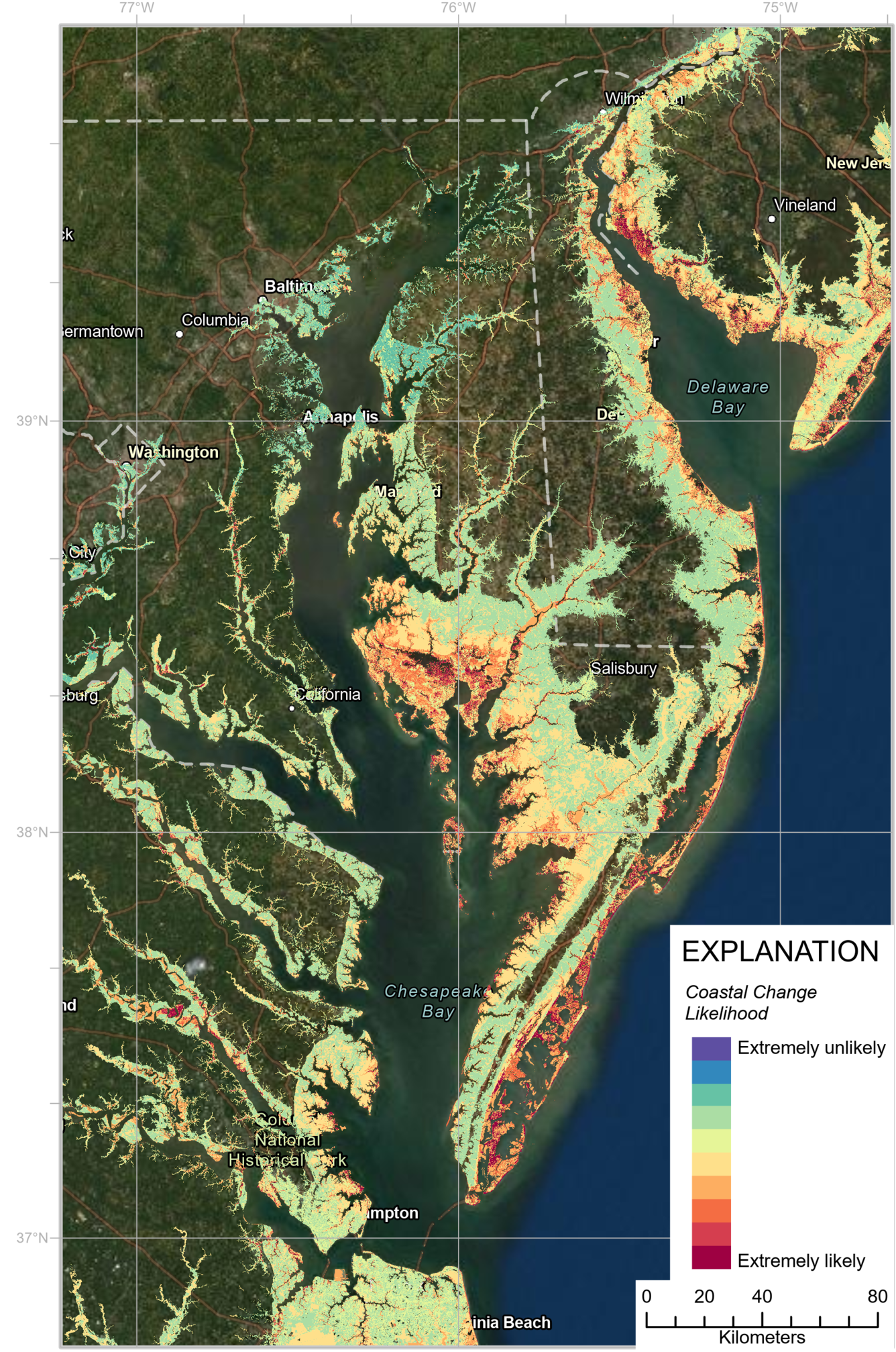
Coastal Change Likelihood
The Coastal Change Likelihood assessment synthesizes over 20 existing datasets from federal, state, and private organizations to understand observed changes and evaluate the likelihood of coastal change over the next decade. The datasets describe the coastal landscape and six common coastal hazards: erosion, storm frequency, relative sea level change, tidal flooding, storm overwash probability, and wave power.
Understanding where landscape change is most likely to occur, and which types of hazards are more likely to adversely affect a specific location (e.g., storm-driven waves, shoreline erosion, and/or sea level change) is essential to planning.
Visit the Coastal Change Likelihood web page to learn more, download the data, and access the geonarrative and interactive maps.

Coastal Landscape Response
The Coastal Landscape Response assessment creates multidecadal predictions of where and when the coast is likely to adapt or inundate. Results are produced for four decades—the 2020s, 2030s, 2050s, and 2080s. This information helps users determine where land will be available in its current or changed form or become submerged in response to future sea level change.
By informing people of where coastal land will likely be available—or not—for future use, land use managers can make long-term plans concerning important infrastructure and valuable resources.

Visit the Coastal Science Navigator product summary page for the Coastal Landscape Response assessment to learn more and access the data for download.

Both products were originally developed for the U.S. Northeast coast. The U.S. Department of Defense is supporting the geographic expansion of these products to the U.S. Southeast and Gulf Coasts.
Products that forecast coastal change likelihood are critical to support informed and proactive planning ensuring national security. By understanding where and when change is expected, decision makers help ensure lives and critical infrastructure are safe and secure, and taxpayer dollars are not wasted on preventable damages and lost revenue.
Source: 1. https://coast.noaa.gov/states/fast-facts/hurricane-costs.html