


USGS Coastal Change Likelihood (CCL) outcomes are displayed for Wallops Joint Expeditionary Base in Virginia. Warm colors indicate areas of high expected coastal change and cool colors indicate areas with lower expected change.
Elizabeth A Pendleton
I am a geologist at the Woods Hole Coastal and Marine Science Center. I am most interested in exploring the complexities, compounding, dependencies, and uncertainties that exist among climate and coastal hazards and landscape change. I rely on spatial analysis, mapping, and machine learning techniques to synthesize coastal datasets into decision support science and products
Research
Research
- Development and Application of a Coastal Change Likelihood Assessment for the N…
- Coastal Change Likelihood in the U.S. Northeast Region: Maine to Virginia
- Shallow Geology, Sea-Floor Texture, and Physiographic Zones of the Inner Contin…
- Optimizing an inner-continental shelf geologic framework investigation through …
- Sand ridge morphology and bedform migration patterns derived from bathymetry an…
- Sea-floor texture and physiographic zones of the inner continental shelf from S…
I am a project coordinator for the Future Landscape Adaptation and Coastal Change project, which provides user-focused, decision-support information through the integration of data and knowledge in multidisciplinary probabilistic frameworks and assessments. The Coastal Change Likelihood assessment is an effort that I lead within this project space that will supersede the popular but outdated Coastal Vulnerability Index (CVI). This update incorporates technological updates and improvements in coastal data source quality, resolution, data processing, stakeholder engagement, and product usability.
I am also a USGS peer support worker (PSW). The training and learning opportunities that the PSW program provides has helped me, professionally and personally, from learning more inclusive language skills to recognizing the value of nuerodiversity and self-care.
Science and Products
Coastal and Marine Science in Long Island Sound
Long Island Sound is a highly productive estuary and vital natural resource bordering New York and Connecticut. It’s essential for its massive economic impact, generating billions annually by supporting recreation, fisheries, and transportation, as well as its biodiversity, serving as a critical habitat for thousands of marine species. USGS research in Long Island Sound helps protect these...

Coastal Responses to Sea-Level Rise: Landscape-Scale Understanding in an Uncertain Future
Rising sea levels and frequent intense storms are rapidly changing Northeastern US coastal landscapes and threatening the vital ecosystem services they provide. Researchers supported by this Northeast CASC project will use landscape models, co-developed with coastal managers and tribal managers, to predict expected coastal changes for different environments (e.g., beaches, wetlands...

Future Landscape Adaptation and Coastal Change (FLACC)
USGS scientists working on the Future Landscape Adaptation and Coastal Change (FLACC) project bring together information on coastal environments, processes, and climate drivers to evaluate where and when future changes along our Nation’s coast may occur and what they may look like.

Coastal Change Likelihood
The U.S. Geological Survey, in partnership with the National Park Service through the Natural Resource Preservation Program, developed the Coastal Change Likelihood (CCL) assessment to determine the future likelihood of coastal change along U.S. coastlines in the next decade. The Northeast United States, from Maine to Virginia, was selected for a proof-of-concept pilot study.

Coastal Vulnerability in National Park Units
These Open-File Reports are part of a joint effort by the U.S. Geological Survey and the National Park Service to map the coastal vulnerability of coastal park units.

Sea-Level Rise Hazards and Decision Support
The Sea-Level Rise Hazards and Decision-Support project assesses present and future coastal vulnerability to provide actionable information for management of our Nation’s coasts. Through multidisciplinary research and collaborative partnerships with decision-makers, physical, biological, and social factors that describe landscape and habitat changes are incorporated in a probabilistic modeling...

Geologic Mapping of the Massachusetts Seafloor
The U.S. Geological Survey, in cooperation with the Massachusetts Office of Coastal Zone Management (CZM) is conducting geologic mapping of the sea floor to characterize the surface and shallow subsurface geologic framework within the Massachusetts coastal zone. The long-term goal of this mapping effort is to produce high-resolution geologic maps and a Geographic Information System (GIS) that will...

Hurricane Sandy Response- Linking the Delmarva Peninsula's Geologic Framework to Coastal Vulnerability
The Delmarva Peninsula is a 220-kilometer-long headland, spit, and barrier island complex that was significantly affected by Hurricane Sandy. In order to better constrain controls on coastal vulnerability and evolution, the region’s sediment sources, transport pathways and sediment sinks must be identified. This project defines the geologic framework of the Delmarva coastal system through...

Sea Floor Mapping Group
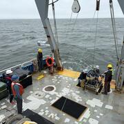
The Sea Floor Mapping Group (SFMG) is a core capability at the Woods Hole Coastal & Marine Science Center (WHCMSC) that provides support for coastal, lacustrine and marine geologic research. The staff has a wide-range of expertise and is responsible for geophysical and sampling data acquisition, processing, interpretation and publication, logistics, design, and research and development. SFMG has...

Aerial Imaging and Mapping
The Aerial Imaging and Mapping group (AIM), at the U.S. Geological Survey Woods (USGS) Hole Coastal and Marine Science Center provides UAS services to scientists to advance the science mission of the Coastal and Marine Geology Program. Scientists at the Woods Hole Coastal and Marine Science Center have been using UASs to acquire imagery of coastal and wetland environments, which is then used to...
Relative Coastal Vulnerability Assessment of National Park Units to Sea-Level Rise
The National Park Service (NPS) is responsible for managing nearly 12,000 km (7,500 miles) of shoreline along oceans and lakes. In 2001 the U.S. Geological Survey (USGS), in partnership with the NPS Geologic Resources Division, began conducting hazard assessments of future sea-level change by creating maps to assist NPS in managing its valuable resources. This website contains results of the...

CCL Outcomes for Wallops Joint Expeditionary Base
USGS Coastal Change Likelihood (CCL) outcomes are displayed for Wallops Joint Expeditionary Base in Virginia. Warm colors indicate areas of high expected coastal change and cool colors indicate areas with lower expected change.

Coastal Change Likelihood
The U.S. Geological Survey, in cooperation with the National Park Service, developed the Coastal Change Likelihood assessment to determine the future likelihood of coastal change along the Northeast U.S. coastline in the next decade. The CCL data displayed here are for the mid-Atlantic Bight, and extend from the shoreline to 10m elevation inland.
The U.S. Geological Survey, in cooperation with the National Park Service, developed the Coastal Change Likelihood assessment to determine the future likelihood of coastal change along the Northeast U.S. coastline in the next decade. The CCL data displayed here are for the mid-Atlantic Bight, and extend from the shoreline to 10m elevation inland.

Coastal Change Likelihood
The U.S. Geological Survey, in cooperation with the National Park Service, developed the Coastal Change Likelihood assessment to determine the future likelihood of coastal change along the Northeast U.S. coastline in the next decade.
The U.S. Geological Survey, in cooperation with the National Park Service, developed the Coastal Change Likelihood assessment to determine the future likelihood of coastal change along the Northeast U.S. coastline in the next decade.

Coastal Change Likelihood
The U.S. Geological Survey, in cooperation with the National Park Service, developed the Coastal Change Likelihood assessment to determine the future likelihood of coastal change along the Northeast U.S. coastline in the next decade. Here is the CCL map for Chesapeake, Va.
The U.S. Geological Survey, in cooperation with the National Park Service, developed the Coastal Change Likelihood assessment to determine the future likelihood of coastal change along the Northeast U.S. coastline in the next decade. Here is the CCL map for Chesapeake, Va.

Coastal Change Likelihood - Fabric Data
The assessment integrates data describing coastal characteristics, landscape composition, and the level of resistance to change to produce the initial fabric layer.
The assessment integrates data describing coastal characteristics, landscape composition, and the level of resistance to change to produce the initial fabric layer.

Coastal Change Likelihood - Perpetual Hazard Data
Data defining the drivers of change that impact the coast, such as waves and flooding are synthesized in hazards layers.
Data defining the drivers of change that impact the coast, such as waves and flooding are synthesized in hazards layers.

Coastal Change Likelihood - Fabric Data
The CCL assessment integrates data describing coastal characteristics, landscape composition, and the level of resistance to change, with data defining the drivers of change that impact the coast, such as waves and flooding. These data types are known as fabric and hazards, respectively.
The CCL assessment integrates data describing coastal characteristics, landscape composition, and the level of resistance to change, with data defining the drivers of change that impact the coast, such as waves and flooding. These data types are known as fabric and hazards, respectively.

CCL and CVI
The CCL is an updated version of the older Coastal Vulnerability Index, first published in 1999. While the original product was focused on change in the next 50-100 years based solely on sea level rise, the new CCL is more near-term, focusing on change over the next decade as a result of multiple coastal hazards.
The CCL is an updated version of the older Coastal Vulnerability Index, first published in 1999. While the original product was focused on change in the next 50-100 years based solely on sea level rise, the new CCL is more near-term, focusing on change over the next decade as a result of multiple coastal hazards.

Coastal Change Likelihood
The CCL is an updated version of the older Coastal Vulnerability Index, first published in 1999. While the original product was focused on change in the next 50-100 years based solely on sea level rise, the new CCL is more near-term, focusing on change over the next decade as a result of multiple coastal hazards.
The CCL is an updated version of the older Coastal Vulnerability Index, first published in 1999. While the original product was focused on change in the next 50-100 years based solely on sea level rise, the new CCL is more near-term, focusing on change over the next decade as a result of multiple coastal hazards.

Coastal Change Likelihood
Where are coastal landscapes likely to change?
Where are coastal landscapes likely to change?

Coastal Change Likelihood
The U.S. Geological Survey, in cooperation with the National Park Service, developed the Coastal Change Likelihood assessment to determine the future likelihood of coastal change along the Northeast coastline in the next decade. Pictured here is coastal change likelihood on Cape Cod.
The U.S. Geological Survey, in cooperation with the National Park Service, developed the Coastal Change Likelihood assessment to determine the future likelihood of coastal change along the Northeast coastline in the next decade. Pictured here is coastal change likelihood on Cape Cod.

UAS pilots at Kilauea
Department of Interior UAS pilots from left to right – Elizabeth Pendleton (USGS, Woods Hole, MA), Colin Milone (Office of Aviation Services, AK), John Vogel (USGS; Flagstaff, AZ), Sandy Brosnahan (USGS, Woods Hole, MA), Brandon Forbes (USGS; Tucson, AZ), Chris Holmquist-Johnson (USGS; Fort Collins, CO),&nb
Department of Interior UAS pilots from left to right – Elizabeth Pendleton (USGS, Woods Hole, MA), Colin Milone (Office of Aviation Services, AK), John Vogel (USGS; Flagstaff, AZ), Sandy Brosnahan (USGS, Woods Hole, MA), Brandon Forbes (USGS; Tucson, AZ), Chris Holmquist-Johnson (USGS; Fort Collins, CO),&nb

Setting Targets in the Great Marsh, Cape Cod, MA
USGS Unmanned Aerial Systems (UAS) pilot, Elizabeth Pendleton, setting a target in Great Marsh, Sandy Neck Beach, Cape Cod, Massachusetts
USGS Unmanned Aerial Systems (UAS) pilot, Elizabeth Pendleton, setting a target in Great Marsh, Sandy Neck Beach, Cape Cod, Massachusetts

Drone flight at Sandy Neck Beach, Cape Cod
Woods Hole Coastal and Marine Science Center Unmanned Aerial Systems (UAS) pilots Sandy Brosnahan (left) and Elizabeth Pendleton conduct a drone flight from atop a dune at Sandy Neck (Cape Cod).
Woods Hole Coastal and Marine Science Center Unmanned Aerial Systems (UAS) pilots Sandy Brosnahan (left) and Elizabeth Pendleton conduct a drone flight from atop a dune at Sandy Neck (Cape Cod).

Night Shift
Woods Hole Coastal and Marine Science Center's Aerial Imaging and Mapping Unmanned Aerial Systems (UAS) pilots, Emily Sturdivant (left) and Elizabeth Pendleton (right) working the night shift in Hawaii at the Kileaua volcano site.
Woods Hole Coastal and Marine Science Center's Aerial Imaging and Mapping Unmanned Aerial Systems (UAS) pilots, Emily Sturdivant (left) and Elizabeth Pendleton (right) working the night shift in Hawaii at the Kileaua volcano site.

Woods Hole UAS Pilots in Hawaii
Providing situational awareness at night, Elizabeth Pendleton, Sandy Brosnahan, and Emily Sturdivant prepare for a UAS take-off
Providing situational awareness at night, Elizabeth Pendleton, Sandy Brosnahan, and Emily Sturdivant prepare for a UAS take-off

Drone Pilot Training!
Elizabeth Pendleton and Seth Ackerman of the Woods Hole Coastal and Marine Science Center at A-450 drone pilot training in Gainesville, Florida in January 2018. Drone pilot training was provided by the DOI Office of Aviation Services (OAS), and was also attended by employees from USGS water and volcano centers, other DOI agencies, and the US Forest Service.
Elizabeth Pendleton and Seth Ackerman of the Woods Hole Coastal and Marine Science Center at A-450 drone pilot training in Gainesville, Florida in January 2018. Drone pilot training was provided by the DOI Office of Aviation Services (OAS), and was also attended by employees from USGS water and volcano centers, other DOI agencies, and the US Forest Service.

Elizabeth Pendleton describes USGS work to map the Mass. seafloor
Elizabeth Pendleton describes USGS work to map the Mass. seafloorElizabeth Pendleton describes USGS work to map the Massachusetts seafloor to State Senator Viriato “Vinny” deMacedo.
Elizabeth Pendleton describes USGS work to map the Mass. seafloor
Elizabeth Pendleton describes USGS work to map the Mass. seafloorElizabeth Pendleton describes USGS work to map the Massachusetts seafloor to State Senator Viriato “Vinny” deMacedo.
Science and Products
Coastal and Marine Science in Long Island Sound
Long Island Sound is a highly productive estuary and vital natural resource bordering New York and Connecticut. It’s essential for its massive economic impact, generating billions annually by supporting recreation, fisheries, and transportation, as well as its biodiversity, serving as a critical habitat for thousands of marine species. USGS research in Long Island Sound helps protect these...
Coastal Responses to Sea-Level Rise: Landscape-Scale Understanding in an Uncertain Future
Rising sea levels and frequent intense storms are rapidly changing Northeastern US coastal landscapes and threatening the vital ecosystem services they provide. Researchers supported by this Northeast CASC project will use landscape models, co-developed with coastal managers and tribal managers, to predict expected coastal changes for different environments (e.g., beaches, wetlands...
Future Landscape Adaptation and Coastal Change (FLACC)
USGS scientists working on the Future Landscape Adaptation and Coastal Change (FLACC) project bring together information on coastal environments, processes, and climate drivers to evaluate where and when future changes along our Nation’s coast may occur and what they may look like.
Coastal Change Likelihood
The U.S. Geological Survey, in partnership with the National Park Service through the Natural Resource Preservation Program, developed the Coastal Change Likelihood (CCL) assessment to determine the future likelihood of coastal change along U.S. coastlines in the next decade. The Northeast United States, from Maine to Virginia, was selected for a proof-of-concept pilot study.
Coastal Vulnerability in National Park Units
These Open-File Reports are part of a joint effort by the U.S. Geological Survey and the National Park Service to map the coastal vulnerability of coastal park units.
Sea-Level Rise Hazards and Decision Support
The Sea-Level Rise Hazards and Decision-Support project assesses present and future coastal vulnerability to provide actionable information for management of our Nation’s coasts. Through multidisciplinary research and collaborative partnerships with decision-makers, physical, biological, and social factors that describe landscape and habitat changes are incorporated in a probabilistic modeling...
Geologic Mapping of the Massachusetts Seafloor
The U.S. Geological Survey, in cooperation with the Massachusetts Office of Coastal Zone Management (CZM) is conducting geologic mapping of the sea floor to characterize the surface and shallow subsurface geologic framework within the Massachusetts coastal zone. The long-term goal of this mapping effort is to produce high-resolution geologic maps and a Geographic Information System (GIS) that will...
Hurricane Sandy Response- Linking the Delmarva Peninsula's Geologic Framework to Coastal Vulnerability
The Delmarva Peninsula is a 220-kilometer-long headland, spit, and barrier island complex that was significantly affected by Hurricane Sandy. In order to better constrain controls on coastal vulnerability and evolution, the region’s sediment sources, transport pathways and sediment sinks must be identified. This project defines the geologic framework of the Delmarva coastal system through...
Sea Floor Mapping Group
The Sea Floor Mapping Group (SFMG) is a core capability at the Woods Hole Coastal & Marine Science Center (WHCMSC) that provides support for coastal, lacustrine and marine geologic research. The staff has a wide-range of expertise and is responsible for geophysical and sampling data acquisition, processing, interpretation and publication, logistics, design, and research and development. SFMG has...
Aerial Imaging and Mapping
The Aerial Imaging and Mapping group (AIM), at the U.S. Geological Survey Woods (USGS) Hole Coastal and Marine Science Center provides UAS services to scientists to advance the science mission of the Coastal and Marine Geology Program. Scientists at the Woods Hole Coastal and Marine Science Center have been using UASs to acquire imagery of coastal and wetland environments, which is then used to...
Relative Coastal Vulnerability Assessment of National Park Units to Sea-Level Rise
The National Park Service (NPS) is responsible for managing nearly 12,000 km (7,500 miles) of shoreline along oceans and lakes. In 2001 the U.S. Geological Survey (USGS), in partnership with the NPS Geologic Resources Division, began conducting hazard assessments of future sea-level change by creating maps to assist NPS in managing its valuable resources. This website contains results of the...
CCL Outcomes for Wallops Joint Expeditionary Base
USGS Coastal Change Likelihood (CCL) outcomes are displayed for Wallops Joint Expeditionary Base in Virginia. Warm colors indicate areas of high expected coastal change and cool colors indicate areas with lower expected change.
USGS Coastal Change Likelihood (CCL) outcomes are displayed for Wallops Joint Expeditionary Base in Virginia. Warm colors indicate areas of high expected coastal change and cool colors indicate areas with lower expected change.
Coastal Change Likelihood
The U.S. Geological Survey, in cooperation with the National Park Service, developed the Coastal Change Likelihood assessment to determine the future likelihood of coastal change along the Northeast U.S. coastline in the next decade. The CCL data displayed here are for the mid-Atlantic Bight, and extend from the shoreline to 10m elevation inland.
The U.S. Geological Survey, in cooperation with the National Park Service, developed the Coastal Change Likelihood assessment to determine the future likelihood of coastal change along the Northeast U.S. coastline in the next decade. The CCL data displayed here are for the mid-Atlantic Bight, and extend from the shoreline to 10m elevation inland.
Coastal Change Likelihood
The U.S. Geological Survey, in cooperation with the National Park Service, developed the Coastal Change Likelihood assessment to determine the future likelihood of coastal change along the Northeast U.S. coastline in the next decade.
The U.S. Geological Survey, in cooperation with the National Park Service, developed the Coastal Change Likelihood assessment to determine the future likelihood of coastal change along the Northeast U.S. coastline in the next decade.
Coastal Change Likelihood
The U.S. Geological Survey, in cooperation with the National Park Service, developed the Coastal Change Likelihood assessment to determine the future likelihood of coastal change along the Northeast U.S. coastline in the next decade. Here is the CCL map for Chesapeake, Va.
The U.S. Geological Survey, in cooperation with the National Park Service, developed the Coastal Change Likelihood assessment to determine the future likelihood of coastal change along the Northeast U.S. coastline in the next decade. Here is the CCL map for Chesapeake, Va.
Coastal Change Likelihood - Fabric Data
The assessment integrates data describing coastal characteristics, landscape composition, and the level of resistance to change to produce the initial fabric layer.
The assessment integrates data describing coastal characteristics, landscape composition, and the level of resistance to change to produce the initial fabric layer.
Coastal Change Likelihood - Perpetual Hazard Data
Data defining the drivers of change that impact the coast, such as waves and flooding are synthesized in hazards layers.
Data defining the drivers of change that impact the coast, such as waves and flooding are synthesized in hazards layers.
Coastal Change Likelihood - Fabric Data
The CCL assessment integrates data describing coastal characteristics, landscape composition, and the level of resistance to change, with data defining the drivers of change that impact the coast, such as waves and flooding. These data types are known as fabric and hazards, respectively.
The CCL assessment integrates data describing coastal characteristics, landscape composition, and the level of resistance to change, with data defining the drivers of change that impact the coast, such as waves and flooding. These data types are known as fabric and hazards, respectively.
CCL and CVI
The CCL is an updated version of the older Coastal Vulnerability Index, first published in 1999. While the original product was focused on change in the next 50-100 years based solely on sea level rise, the new CCL is more near-term, focusing on change over the next decade as a result of multiple coastal hazards.
The CCL is an updated version of the older Coastal Vulnerability Index, first published in 1999. While the original product was focused on change in the next 50-100 years based solely on sea level rise, the new CCL is more near-term, focusing on change over the next decade as a result of multiple coastal hazards.
Coastal Change Likelihood
The CCL is an updated version of the older Coastal Vulnerability Index, first published in 1999. While the original product was focused on change in the next 50-100 years based solely on sea level rise, the new CCL is more near-term, focusing on change over the next decade as a result of multiple coastal hazards.
The CCL is an updated version of the older Coastal Vulnerability Index, first published in 1999. While the original product was focused on change in the next 50-100 years based solely on sea level rise, the new CCL is more near-term, focusing on change over the next decade as a result of multiple coastal hazards.
Coastal Change Likelihood
Where are coastal landscapes likely to change?
Where are coastal landscapes likely to change?
Coastal Change Likelihood
The U.S. Geological Survey, in cooperation with the National Park Service, developed the Coastal Change Likelihood assessment to determine the future likelihood of coastal change along the Northeast coastline in the next decade. Pictured here is coastal change likelihood on Cape Cod.
The U.S. Geological Survey, in cooperation with the National Park Service, developed the Coastal Change Likelihood assessment to determine the future likelihood of coastal change along the Northeast coastline in the next decade. Pictured here is coastal change likelihood on Cape Cod.
UAS pilots at Kilauea
Department of Interior UAS pilots from left to right – Elizabeth Pendleton (USGS, Woods Hole, MA), Colin Milone (Office of Aviation Services, AK), John Vogel (USGS; Flagstaff, AZ), Sandy Brosnahan (USGS, Woods Hole, MA), Brandon Forbes (USGS; Tucson, AZ), Chris Holmquist-Johnson (USGS; Fort Collins, CO),&nb
Department of Interior UAS pilots from left to right – Elizabeth Pendleton (USGS, Woods Hole, MA), Colin Milone (Office of Aviation Services, AK), John Vogel (USGS; Flagstaff, AZ), Sandy Brosnahan (USGS, Woods Hole, MA), Brandon Forbes (USGS; Tucson, AZ), Chris Holmquist-Johnson (USGS; Fort Collins, CO),&nb
Setting Targets in the Great Marsh, Cape Cod, MA
USGS Unmanned Aerial Systems (UAS) pilot, Elizabeth Pendleton, setting a target in Great Marsh, Sandy Neck Beach, Cape Cod, Massachusetts
USGS Unmanned Aerial Systems (UAS) pilot, Elizabeth Pendleton, setting a target in Great Marsh, Sandy Neck Beach, Cape Cod, Massachusetts
Drone flight at Sandy Neck Beach, Cape Cod
Woods Hole Coastal and Marine Science Center Unmanned Aerial Systems (UAS) pilots Sandy Brosnahan (left) and Elizabeth Pendleton conduct a drone flight from atop a dune at Sandy Neck (Cape Cod).
Woods Hole Coastal and Marine Science Center Unmanned Aerial Systems (UAS) pilots Sandy Brosnahan (left) and Elizabeth Pendleton conduct a drone flight from atop a dune at Sandy Neck (Cape Cod).
Night Shift
Woods Hole Coastal and Marine Science Center's Aerial Imaging and Mapping Unmanned Aerial Systems (UAS) pilots, Emily Sturdivant (left) and Elizabeth Pendleton (right) working the night shift in Hawaii at the Kileaua volcano site.
Woods Hole Coastal and Marine Science Center's Aerial Imaging and Mapping Unmanned Aerial Systems (UAS) pilots, Emily Sturdivant (left) and Elizabeth Pendleton (right) working the night shift in Hawaii at the Kileaua volcano site.
Woods Hole UAS Pilots in Hawaii
Providing situational awareness at night, Elizabeth Pendleton, Sandy Brosnahan, and Emily Sturdivant prepare for a UAS take-off
Providing situational awareness at night, Elizabeth Pendleton, Sandy Brosnahan, and Emily Sturdivant prepare for a UAS take-off
Drone Pilot Training!
Elizabeth Pendleton and Seth Ackerman of the Woods Hole Coastal and Marine Science Center at A-450 drone pilot training in Gainesville, Florida in January 2018. Drone pilot training was provided by the DOI Office of Aviation Services (OAS), and was also attended by employees from USGS water and volcano centers, other DOI agencies, and the US Forest Service.
Elizabeth Pendleton and Seth Ackerman of the Woods Hole Coastal and Marine Science Center at A-450 drone pilot training in Gainesville, Florida in January 2018. Drone pilot training was provided by the DOI Office of Aviation Services (OAS), and was also attended by employees from USGS water and volcano centers, other DOI agencies, and the US Forest Service.
Elizabeth Pendleton describes USGS work to map the Mass. seafloor
Elizabeth Pendleton describes USGS work to map the Mass. seafloorElizabeth Pendleton describes USGS work to map the Massachusetts seafloor to State Senator Viriato “Vinny” deMacedo.
Elizabeth Pendleton describes USGS work to map the Mass. seafloor
Elizabeth Pendleton describes USGS work to map the Mass. seafloorElizabeth Pendleton describes USGS work to map the Massachusetts seafloor to State Senator Viriato “Vinny” deMacedo.