Flow over road on way to Teton Riv nr Dutton streamgage
Flow over road on way to Teton Riv nr Dutton streamgageFlow over road on way to Teton Riv nr Dutton streamgage

Official websites use .gov
A .gov website belongs to an official government organization in the United States.
Secure .gov websites use HTTPS
A lock () or https:// means you’ve safely connected to the .gov website. Share sensitive information only on official, secure websites.
Some collected images in Wyoming and Montana.

Flow over road on way to Teton Riv nr Dutton streamgage
Flow over road on way to Teton Riv nr Dutton streamgage

Processing a sample for detection of N. fowleri

Equipment used to process a water sample to be analyzed for Naegleria fowleri
Equipment used to process a water sample to be analyzed for Naegleria fowleri

Collecting a water sample for Naegleria fowleri detection in a Yellowstone National Park Hot Springs
Collecting a water sample for Naegleria fowleri detection in a Yellowstone National Park Hot Springs

Processing sample from Granite Hot Springs

Wading measurements are taken for streamflow on the Gros Ventre River near Zenith, Wyoming while bridge construction is carried out upstream.
Wading measurements are taken for streamflow on the Gros Ventre River near Zenith, Wyoming while bridge construction is carried out upstream.

Measuring streamflow with ADCP on the South Fork of the Shoshone River near Valley, WYoming.
Measuring streamflow with ADCP on the South Fork of the Shoshone River near Valley, WYoming.

Mother nature left us some cushions for a more comfortable cable car ride at Pine Creek above Fremont Lake.
Mother nature left us some cushions for a more comfortable cable car ride at Pine Creek above Fremont Lake.

Measuring streamflow, New Fork River near Big Piney (09205000)
Measuring streamflow, New Fork River near Big Piney (09205000)

Slush in Yellowstone River at Billings required old-school AA meter rather than ADCP which is typically used at this site.
Slush in Yellowstone River at Billings required old-school AA meter rather than ADCP which is typically used at this site.

Wyoming Range WLCI small stream study locations

Cutting through 2-ft thick ice to sample Yellowstone River, Sidney MT
Cutting through 2-ft thick ice to sample Yellowstone River, Sidney MT

Cooperator, Blackfeet Nation, Reservation Groundwater Hydrologic Monitoring area map in Montana.
Cooperator, Blackfeet Nation, Reservation Groundwater Hydrologic Monitoring area map in Montana.

Eric Blajszczak teaches 5th graders about water & measuring streamflow
Eric Blajszczak teaches 5th graders about water & measuring streamflow

Mean annual streamflow permanence probability in a section of the Blackfoot River Basin near Deer Lodge, MT. Blue pixels indicate higher probability of streamflow permanence and red pixels indicate lower probability of streamflow permanence.
Mean annual streamflow permanence probability in a section of the Blackfoot River Basin near Deer Lodge, MT. Blue pixels indicate higher probability of streamflow permanence and red pixels indicate lower probability of streamflow permanence.

Variability associated with streamflow permanence predictions
Variability associated with streamflow permanence predictions

Stream observation points and focal basins for PROSPER project
Stream observation points and focal basins for PROSPER project
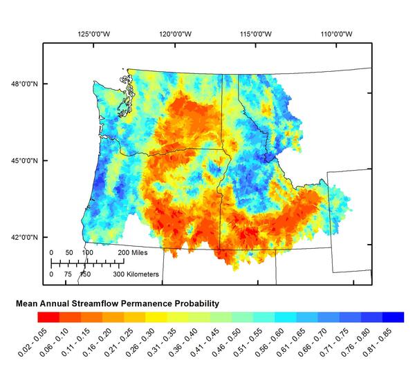
Mean Annual Streamflow Permanence Probability

Locations of wells sampled 1996-2005 and notation of pesticide detected (red dot)
Locations of wells sampled 1996-2005 and notation of pesticide detected (red dot)

ADCP streamflow measurement, Wind River near Dubois

Wading slush to measure streamflow, S Fk Shoshone abv Buffalo Bill Res
Wading slush to measure streamflow, S Fk Shoshone abv Buffalo Bill Res