
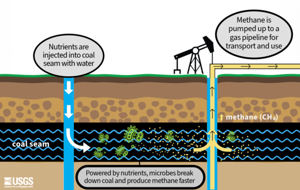
A graphic showing the process of enhancing microbial methane production with the addition of nutrients to underground coal formations.
Images
Some collected images in Wyoming and Montana.
Filter Total Items: 445
Biogenic Gas Production
A graphic showing the process of enhancing microbial methane production with the addition of nutrients to underground coal formations.

Microbial methane production graphic
A graphic showing the process of enhanced microbial methane production. Nutrients are added to underground coalbeds, where they cause microbes to produce methane faster. This methane is then pumped up to the surface for transport and use.
A graphic showing the process of enhanced microbial methane production. Nutrients are added to underground coalbeds, where they cause microbes to produce methane faster. This methane is then pumped up to the surface for transport and use.

Bozeman Field Office
An image of the Bozeman Field Office site for the Wyoming-Montana Water Science Center.
An image of the Bozeman Field Office site for the Wyoming-Montana Water Science Center.

Monitoring Jackson Hole Elk
An image of elk standing behind a groundwater monitoring site at Jackson Hole Airport in Wyoming.
An image of elk standing behind a groundwater monitoring site at Jackson Hole Airport in Wyoming.

Richardson Wetland Mitigation Site
An image of a wetland monitoring site (Richmond) west of Missoula, Montana.
An image of a wetland monitoring site (Richmond) west of Missoula, Montana.

Microbe methane cafe
A graphic showing microbes consuming nutrients and releasing (or farting) methane (CH4) out in the process.
A graphic showing microbes consuming nutrients and releasing (or farting) methane (CH4) out in the process.

Jackson Hole Groundwater Well
Jackson Hole Airport groundwater well used for sampling water quality. Well used by USGS to track water quality over time.
Jackson Hole Airport groundwater well used for sampling water quality. Well used by USGS to track water quality over time.

Streamgage view at Two Medicine River above Badger Creek near Piegan, MT during fall
Streamgage view at Two Medicine River above Badger Creek near Piegan, MT during fall06092020 streamgage at Two Medicine River above Badger Creek, near Piegan, Montana.
Streamgage view at Two Medicine River above Badger Creek near Piegan, MT during fall
Streamgage view at Two Medicine River above Badger Creek near Piegan, MT during fall06092020 streamgage at Two Medicine River above Badger Creek, near Piegan, Montana.

Cut Bank Creek above Gillam Coulee, near Sundance, MT
Cut Bank Creek above Gillam Coulee, near Sundance, MTView from at Cut Bank Creek above Gillam Coulee, near Sundance, Montana during fall site visit
Cut Bank Creek above Gillam Coulee, near Sundance, MT
Cut Bank Creek above Gillam Coulee, near Sundance, MTView from at Cut Bank Creek above Gillam Coulee, near Sundance, Montana during fall site visit

Wyoming StreamStats Application Screenshot
Screenshot of StreamStat application in Wyoming, with the Teton and Wind River Mountain Ranges
Screenshot of StreamStat application in Wyoming, with the Teton and Wind River Mountain Ranges

USGS 13013650 location map
Arieal map of area by USGS 13013650 on the Snake River bridge between Moose, WY and Craig Thomas Discovery Center
Arieal map of area by USGS 13013650 on the Snake River bridge between Moose, WY and Craig Thomas Discovery Center

Streamgage 13011000 location
USGS topographic map of the area where Streamgage 13011000 is located downstream of Jackson Lake Dam
USGS topographic map of the area where Streamgage 13011000 is located downstream of Jackson Lake Dam

Missouri and Milk River water-quality monitoring streamgages
Missouri and Milk River water-quality monitoring streamgagesAerial map of the three USGS streamgage locations for a water-quality monitoring project along the Milk River and Missouri River.
Missouri and Milk River water-quality monitoring streamgages
Missouri and Milk River water-quality monitoring streamgagesAerial map of the three USGS streamgage locations for a water-quality monitoring project along the Milk River and Missouri River.

Selenium Transport Map Elk River to Columbia River
Selenium Transport Map Elk River to Columbia RiverSite map of the transboundary Kootenay River Basin depecting the mining activity, study locations and transport of selenium through the basin to the Columbia River Basin.
Selenium Transport Map Elk River to Columbia River
Selenium Transport Map Elk River to Columbia RiverSite map of the transboundary Kootenay River Basin depecting the mining activity, study locations and transport of selenium through the basin to the Columbia River Basin.

Flood-Frequency Analysis in the Midwest Collaborators Map
Flood-Frequency Analysis in the Midwest Collaborators MapMap of the seven-state collaborators involved in Flood-Frequency Analysis in the Midwest: Addressing Potential Nonstationary Annual Peak-Flow Records
Flood-Frequency Analysis in the Midwest Collaborators Map
Flood-Frequency Analysis in the Midwest Collaborators MapMap of the seven-state collaborators involved in Flood-Frequency Analysis in the Midwest: Addressing Potential Nonstationary Annual Peak-Flow Records

Hydrologists inventory groundwater well on Blackfeet Reservation, Montana
Hydrologists inventory groundwater well on Blackfeet Reservation, MontanaTwo Wyoming-Montana Water Science Center hydrologists take inventory of a groundwater well on the Blackfeet Reservation in Montana. This is a phase of the Hydrologic Assessment of Blackfeet Reservation, Montana project.

USGS Hydrologist performs a Groundwater Well Inventory Check
USGS Hydrologist performs a Groundwater Well Inventory CheckUSGS WY-MT Water Science Center hydrologist taking a groundwater well inventory at Blackfeet Nation in Montana
USGS Hydrologist performs a Groundwater Well Inventory Check
USGS Hydrologist performs a Groundwater Well Inventory CheckUSGS WY-MT Water Science Center hydrologist taking a groundwater well inventory at Blackfeet Nation in Montana

Lake Koocanusa, Canada
View from a research vessel on Lake Koocanusa while collecting samples for monitoring selenium
View from a research vessel on Lake Koocanusa while collecting samples for monitoring selenium

USGS 0617700 streamgage bidge near Wolf Point, MT
View of bridge at USGS 0617700 streamgage near Wolf Point, MT looking at the Missouri River
View of bridge at USGS 0617700 streamgage near Wolf Point, MT looking at the Missouri River

06174500 Milk River at Nashua, MT
Streamgage with water-quality sonde at USGS gage 06174500 looking towards the Milk River at Nashua, MT. Newly installed sonde for water-quality monitoring.
Streamgage with water-quality sonde at USGS gage 06174500 looking towards the Milk River at Nashua, MT. Newly installed sonde for water-quality monitoring.

USGS 06177000 Missouri River near Wolf Point, MT streamgage
USGS 06177000 Missouri River near Wolf Point, MT streamgageUSGS 06177000 Missouri River near Wolf Point, MT streamgage looking at the Missouri river and bridge
USGS 06177000 Missouri River near Wolf Point, MT streamgage
USGS 06177000 Missouri River near Wolf Point, MT streamgageUSGS 06177000 Missouri River near Wolf Point, MT streamgage looking at the Missouri river and bridge