
Using the device pictured here, government scientists are measuring snowfall in remote areas with a bucket, a small windmill, and the sun -- all the while saving money, energy, and ultimately helping to save lives.
Images
Images
Filter Total Items: 9448

Measuring Snowfall with Solar Panels
Using the device pictured here, government scientists are measuring snowfall in remote areas with a bucket, a small windmill, and the sun -- all the while saving money, energy, and ultimately helping to save lives.

Career Day - A Day on the Water
Showing the son of a USGS employee "what we do" on the Tangipahoa R., LA
Showing the son of a USGS employee "what we do" on the Tangipahoa R., LA

You Get PAID to Do This?
Malik Chavis wants to work for the USGS.
Malik Chavis wants to work for the USGS.

USGS and President of Tanzania
USGS Volcano Disaster Assistance Program Representative (VDAP) Gari Mayberry presents the draft VDAP report to President Kikwete of Tanzania with the Charge d'Affairs Larry Andre.
USGS Volcano Disaster Assistance Program Representative (VDAP) Gari Mayberry presents the draft VDAP report to President Kikwete of Tanzania with the Charge d'Affairs Larry Andre.

Red Mangroves in Hurricane Hole, US Virgin Islands
Red Mangroves in Hurricane Hole, US Virgin IslandsIn Hurricane Hole, Red Mangrove trees extend from land into the water, anchoring the trees along the shoreline and creating a rich marine ecosystem.
Red Mangroves in Hurricane Hole, US Virgin Islands
Red Mangroves in Hurricane Hole, US Virgin IslandsIn Hurricane Hole, Red Mangrove trees extend from land into the water, anchoring the trees along the shoreline and creating a rich marine ecosystem.

Ol Doinyo Lengai Volcano
The village of Naiyobi, about 5 miles from the summit of Ol Doinyo Lengai, has had ashfall from recent eruptions that have impacted residents and their cattle.
The village of Naiyobi, about 5 miles from the summit of Ol Doinyo Lengai, has had ashfall from recent eruptions that have impacted residents and their cattle.

Ol Doinyo Lengai Volcano
Scientists from the Volcano Disaster Assistance Program team and the Geological Survey of Tanzania take a sample of the most recent ashfall from Ol Doinyo Lengai as the volcano looms in the background.
Scientists from the Volcano Disaster Assistance Program team and the Geological Survey of Tanzania take a sample of the most recent ashfall from Ol Doinyo Lengai as the volcano looms in the background.

Science Collaboration on Ol Doinyo Lengai Volcano
USGS Scientist David Sherrod and a guide complete digging for ash samples from the most recent eruption of Ol Doinyo Lengai Volcano in Tanzania.
USGS Scientist David Sherrod and a guide complete digging for ash samples from the most recent eruption of Ol Doinyo Lengai Volcano in Tanzania.

Broad-Billed Hummingbird
Hummingbirds traditionally wintering in the tropics now routinely winter along the northern Gulf of Mexico coast
Hummingbirds traditionally wintering in the tropics now routinely winter along the northern Gulf of Mexico coast

Surveying Ol Doinyo Lengai Volcano
USGS Scientist David Sherrod surveys Ol Doinyo Lengai Volcano in Tanzania with scientists from the Geological Survey of Tanzania and local villagers.
USGS Scientist David Sherrod surveys Ol Doinyo Lengai Volcano in Tanzania with scientists from the Geological Survey of Tanzania and local villagers.

Science Collaboration on Ol Doinyo Lengai Volcano
USGS volcanologist David Sherrod discusses activity at Ol Doinyo Lengai volcano with the Director of the Tanzanian Geological Survey, Abdul Mruma, as a local Maasai woman observes.
USGS volcanologist David Sherrod discusses activity at Ol Doinyo Lengai volcano with the Director of the Tanzanian Geological Survey, Abdul Mruma, as a local Maasai woman observes.

Red Mangrove (Rhizophora mangle) Aquatic Habitat for Coral
Red Mangrove (Rhizophora mangle) Aquatic Habitat for CoralProp roots of the Red Mangrove (Rhizophora mangle) tree create thickets that harbor a wide variety of creatures both above and below the water.
Red Mangrove (Rhizophora mangle) Aquatic Habitat for Coral
Red Mangrove (Rhizophora mangle) Aquatic Habitat for CoralProp roots of the Red Mangrove (Rhizophora mangle) tree create thickets that harbor a wide variety of creatures both above and below the water.

Red Mangrove Trees
A view of red mangrove trees and their prop roots above and below the water surface.
A view of red mangrove trees and their prop roots above and below the water surface.

Trees Buried in Volcanic Sediment, Sandy River 1
Trunks of forest trees, initially growing on a terrace above the Sandy River (Oregon) at Oxbow Regional Park, were buried by rapid deposition of sediment following a dome-building eruption at Mount Hood in 1781. Erosion during a flood about a week before the photo was taken exposed this "ghost forest".
Trunks of forest trees, initially growing on a terrace above the Sandy River (Oregon) at Oxbow Regional Park, were buried by rapid deposition of sediment following a dome-building eruption at Mount Hood in 1781. Erosion during a flood about a week before the photo was taken exposed this "ghost forest".

Trees Buried in Volcanic Sediment, Sandy River 2
Trunks of forest trees, initially growing on a terrace above the Sandy River (Oregon) at Oxbow Regional Park, were buried by rapid deposition of sediment following a dome-building eruption at Mount Hood in 1781. Erosion during a flood about a week before the photo was taken exposed this "ghost forest".
Trunks of forest trees, initially growing on a terrace above the Sandy River (Oregon) at Oxbow Regional Park, were buried by rapid deposition of sediment following a dome-building eruption at Mount Hood in 1781. Erosion during a flood about a week before the photo was taken exposed this "ghost forest".
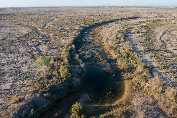
Colorado River Runs Dry
The Colorado River runs dry on the U.S./Mexico border 2
miles below the Morelos Dam.
The Colorado River runs dry on the U.S./Mexico border 2
miles below the Morelos Dam.

Science Collaboration on Tanzanian Hazards
USGS Scientist Gari Mayberry discusses the volcano hazards in Tanzania with a scientist from the Geological Survey of Tanzania.
USGS Scientist Gari Mayberry discusses the volcano hazards in Tanzania with a scientist from the Geological Survey of Tanzania.
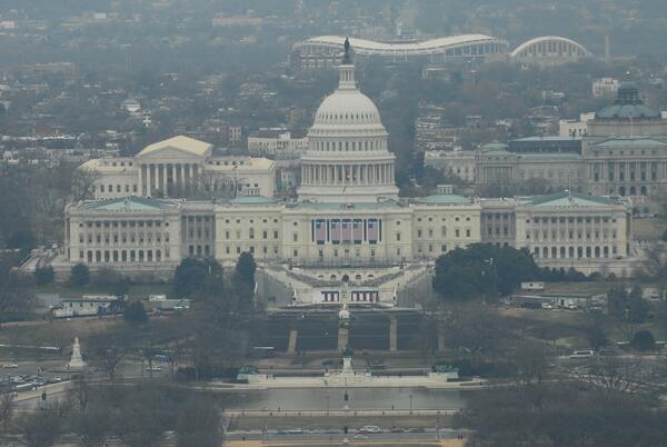
U.S. Capitol
The United States Capitol building and the presidential inauguration swearing-in stand.
The United States Capitol building and the presidential inauguration swearing-in stand.

Prop Roots Colinized with Colorful Sponges
Prop roots extending into the water column are commonly colonized by a variety of colorful and bizarrely-shaped sponges.
Prop roots extending into the water column are commonly colonized by a variety of colorful and bizarrely-shaped sponges.

Coral Colonies Growing Under Mangrove Prop Trees
A grooved brain coral, a massive starlet coral and a boulder brain coral growing under mangrove prop roots.
A grooved brain coral, a massive starlet coral and a boulder brain coral growing under mangrove prop roots.

Adult Male Elephant Seal
An adult male elephant seal at Año Nuevo State Natural Reserve in California. This "loser" has been pushed out to the periphery of the mating bull's harem.
An adult male elephant seal at Año Nuevo State Natural Reserve in California. This "loser" has been pushed out to the periphery of the mating bull's harem.