
Two populations of mule deer featured in the new USGS report perform transboundary migrations between winter ranges in the Wind River Indian Reservation and summer ranges in surrounding federal lands in Wyoming.
Images
Images
Filter Total Items: 9448

Mule Deer migrating in Wyoming
Two populations of mule deer featured in the new USGS report perform transboundary migrations between winter ranges in the Wind River Indian Reservation and summer ranges in surrounding federal lands in Wyoming.

Photo of Spring Lake in San Marcos, Texas
Spring Lake in San Marcos, Texas, has hundreds of small springs underneath it.
A new website now provides important information about streamflow in the Comal and San Marcos Rivers and springflow at Comal and San Marcos Springs.
Spring Lake in San Marcos, Texas, has hundreds of small springs underneath it.
A new website now provides important information about streamflow in the Comal and San Marcos Rivers and springflow at Comal and San Marcos Springs.

Downstream Pembina River
The Pembina River at Neche, ND looking downstream.
The Pembina River at Neche, ND looking downstream.
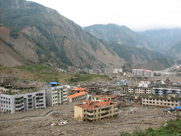
Damage from 2008 Great Sichuan Earthquake in China
Damage from 2008 Great Sichuan Earthquake in ChinaThe May 12, 2008, Great Sichuan Earthquake, also called the Wenchuan Earthquake, occurred at 14:28 local time, in Sichuan Province, China. The earthquake magnitudes were Mw = 7.9 (USGS), Ms = 8.0 (Chinese Earthquake Administration). The epicenter was 80 km west-northwest of Chengdu, the capital city of Sichuan province.

Red River of the North at Fargo ND
Red River of the North at Fargo, North Dakota in 2008.
Red River of the North at Fargo, North Dakota in 2008.

Fall Foliage Along Blue Ridge Parkway
View of Blue Ridge Parkway foliage from Waterrock Knob at sunset.
View of Blue Ridge Parkway foliage from Waterrock Knob at sunset.

Summit of Waterrock Knob
View from Summit of Waterrock Knob at 6,292 feet. It is the 16th highest peak in the Eastern US and located within the Blue Ridge Pkwy.
View from Summit of Waterrock Knob at 6,292 feet. It is the 16th highest peak in the Eastern US and located within the Blue Ridge Pkwy.

Summit of Waterrock Knob
View from Summit of Waterrock Knob at 6,292 feet. It is the 16th highest peak in the Eastern US and located within the Blue Ridge Pkwy.
View from Summit of Waterrock Knob at 6,292 feet. It is the 16th highest peak in the Eastern US and located within the Blue Ridge Pkwy.

Fall Foliage from Waterrock Knob
View of fall foliage from Waterrock Knob Mt. peak in the Plott Balsam Mt. chain.
View of fall foliage from Waterrock Knob Mt. peak in the Plott Balsam Mt. chain.

Fall Foliage along Blue Ridge Parkway
Bright fall foliage along the Blue Ridge Parkway.
Bright fall foliage along the Blue Ridge Parkway.

Blue Ridge Parkway With Fall Foliage
Climbing Waterrock Knob and viewing the Blue Ridge Pkwy below with the fall foliage around.
Climbing Waterrock Knob and viewing the Blue Ridge Pkwy below with the fall foliage around.

Fall Foliage Along Blue Ridge Parkway
Bright fall foliage along the Blue Ridge Parkway.
Bright fall foliage along the Blue Ridge Parkway.

Fall Foliage Along Blue Ridge Parkway
View of Blue Ridge Parkway foliage from Waterrock Knob at sunset.
View of Blue Ridge Parkway foliage from Waterrock Knob at sunset.

Summit of Waterrock Knob
View from Summit of Waterrock Knob at 6,292 feet. It is the 16th highest peak in the Eastern US and located within the Blue Ridge Pkwy.
View from Summit of Waterrock Knob at 6,292 feet. It is the 16th highest peak in the Eastern US and located within the Blue Ridge Pkwy.

Blue Ridge Parkway With Fall Foliage
View of Blue Ridge Parkway foliage from Waterrock Knob.
View of Blue Ridge Parkway foliage from Waterrock Knob.

Fall Foliage From Waterrock Knob
View from Summit of Waterrock Knob at 6,292 feet. It is the 16th highest peak in the Eastern US and located within the Blue Ridge Pkwy.
View from Summit of Waterrock Knob at 6,292 feet. It is the 16th highest peak in the Eastern US and located within the Blue Ridge Pkwy.

Summit of Waterrock Knob
View from Summit of Waterrock Knob at 6,292 feet. It is the 16th highest peak in the Eastern US and located within the Blue Ridge Pkwy.
View from Summit of Waterrock Knob at 6,292 feet. It is the 16th highest peak in the Eastern US and located within the Blue Ridge Pkwy.

Train on Cajon Pass
Train crossing the San Andreas Fault at Cajon Pass, CA
Train crossing the San Andreas Fault at Cajon Pass, CA

Utilities on San Andreas Fault
Directly on the San Andreas with high pressure gas lines underground and high voltage power lines overhead at Cajon Pass, CA
Directly on the San Andreas with high pressure gas lines underground and high voltage power lines overhead at Cajon Pass, CA

Fall Foliage in North Carolina Mountains
Evening sunset over the mountains in Waynesville.
Evening sunset over the mountains in Waynesville.

Train on Cajon Pass
Train crossing the San Andreas Fault at Cajon Pass, CA
Train crossing the San Andreas Fault at Cajon Pass, CA