
A USGS hydrologist prepares equipment to conduct a gravity survey to evaluate small variations in the earth's gravity field. The USGS Office of Groundwater Branch of Geophysics develops and tests new tools and field methods to support USGS analysis of groundwater flow systems.
Images
Images
Filter Total Items: 9454

Near-Surface Gravity Survey
A USGS hydrologist prepares equipment to conduct a gravity survey to evaluate small variations in the earth's gravity field. The USGS Office of Groundwater Branch of Geophysics develops and tests new tools and field methods to support USGS analysis of groundwater flow systems.
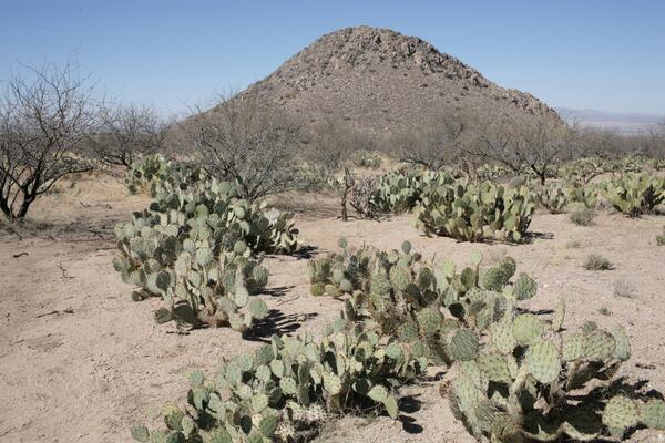
Huérfano Butte, Santa Rita Experimental Range, Southern Arizona - 2007
Huérfano Butte, Santa Rita Experimental Range, Southern Arizona - 2007More mesquite were visible, and prickly pear had replaced cholla as the dominant cacti. (Mitchel P. McClaran).
Huérfano Butte, Santa Rita Experimental Range, Southern Arizona - 2007
Huérfano Butte, Santa Rita Experimental Range, Southern Arizona - 2007More mesquite were visible, and prickly pear had replaced cholla as the dominant cacti. (Mitchel P. McClaran).

Using GPS in the Field
USGS hydrologist collects location data using GPS during a near-surface geophysics survey. The survey was conducted as part of an applied research effort by the USGS Office of Groundwater Branch of Geophysics in 2007.
USGS hydrologist collects location data using GPS during a near-surface geophysics survey. The survey was conducted as part of an applied research effort by the USGS Office of Groundwater Branch of Geophysics in 2007.

Rio Nigua at Turnpike
A fire scar is visible on the distant hills. During the dry season brush fires are common in Salinas, Puerto Rico. The vegetation near the river is greener and burns less often then the hillslopes. The location is 17º59'15"N, 66º17'40"W and the elevation is 10 m.
A fire scar is visible on the distant hills. During the dry season brush fires are common in Salinas, Puerto Rico. The vegetation near the river is greener and burns less often then the hillslopes. The location is 17º59'15"N, 66º17'40"W and the elevation is 10 m.

Cone on Pavonis Mons
A cone located on Pavonis Mons, Mars. Pavonis Mons is a shield volcano in the Tharsis region. This cone’s location in a volcanically active area, its parasitic position on Pavonis Mons, and its breach are all familiar to Earth cinder cones. It’s thus very likely that this is a cinder cone. (HiRISE image PSP_002671_1790)
A cone located on Pavonis Mons, Mars. Pavonis Mons is a shield volcano in the Tharsis region. This cone’s location in a volcanically active area, its parasitic position on Pavonis Mons, and its breach are all familiar to Earth cinder cones. It’s thus very likely that this is a cinder cone. (HiRISE image PSP_002671_1790)

Gas Hydrate Well
Mount Elbert gas hydrate stratigraphic test well on the North Slope of Alaska.
Mount Elbert gas hydrate stratigraphic test well on the North Slope of Alaska.

Fractured mounds in Elysium Planitia
A larger view of the area in which possible tumuli are located. The mounds are at the southern edge of Elysium Planitia. Elysium Planitia is a wide plain that lies to the south of the volcanic region Elysium. These features are found in a region of uplift that is theorized to be a massive lava inflation feature.
A larger view of the area in which possible tumuli are located. The mounds are at the southern edge of Elysium Planitia. Elysium Planitia is a wide plain that lies to the south of the volcanic region Elysium. These features are found in a region of uplift that is theorized to be a massive lava inflation feature.

Fractured mounds in Elysium Planitia
Fractured mounds at the southern edge of Elysium Planitia. Elysium Planitia is a wide plain that lies to the south of the volcanic region Elysium. These features are found in a region of uplift that is theorized to be a massive lava inflation feature.
Fractured mounds at the southern edge of Elysium Planitia. Elysium Planitia is a wide plain that lies to the south of the volcanic region Elysium. These features are found in a region of uplift that is theorized to be a massive lava inflation feature.

Glass Sponge (Euplectella sp.)
The dried siliceous skeleton of the deep sea glass sponge, Euplectella.
The dried siliceous skeleton of the deep sea glass sponge, Euplectella.

Glass Sponge (Euplectella sp.)
The dried siliceous skeleton of the deep sea glass sponge, Euplectella.
The dried siliceous skeleton of the deep sea glass sponge, Euplectella.

Osprey (Pandion haliaetus)
Osprey nesting on a structure at Merritt Island National Wildlife Refuge.
Osprey nesting on a structure at Merritt Island National Wildlife Refuge.

Unidentified Palm and Pine Trees
Pine trees and palm trees seen at the Merritt Island Wildlife Refuge. These palms show evidence of exposure to a wildfire.
Pine trees and palm trees seen at the Merritt Island Wildlife Refuge. These palms show evidence of exposure to a wildfire.

Shrubs at Merritt Island Wildlife Refuge
Shrubs and grass at the Merritt Island Wildlife Refuge showing evidence of a wildfire.
Shrubs and grass at the Merritt Island Wildlife Refuge showing evidence of a wildfire.

Unidentified Palm Trees
Palm trees at the Merritt Island Wildlife Refuge. These palms show evidence of exposure to a wildfire.
Palm trees at the Merritt Island Wildlife Refuge. These palms show evidence of exposure to a wildfire.

Palms and Pines in a Forest
Pine trees and palm trees standing among fallen trees at the Merritt Island Wildlife Refuge. Both pines and palms show evidence of exposure to a wildfire.
Pine trees and palm trees standing among fallen trees at the Merritt Island Wildlife Refuge. Both pines and palms show evidence of exposure to a wildfire.

Palms and Pines in a Forest
Tall pine trees standing among fallen trees at the Merritt Island Wildlife Refuge. Palm trees are seen on the left side of the image. Both pines and palms show evidence of exposure to wildfire.
Tall pine trees standing among fallen trees at the Merritt Island Wildlife Refuge. Palm trees are seen on the left side of the image. Both pines and palms show evidence of exposure to wildfire.

Palm Trees in a Forest
Pine trees and fallen branches at the Merritt Island Wildlife Refuge. These palms show evidence of exposure to a wildfire.
Pine trees and fallen branches at the Merritt Island Wildlife Refuge. These palms show evidence of exposure to a wildfire.

Pine Trees in a Forest
View of pine trees at Merritt Island Wildlife Refuge. Palm trees are seen on the left side of the image. Both pines and palms show evidence of exposure to a wildfire.
View of pine trees at Merritt Island Wildlife Refuge. Palm trees are seen on the left side of the image. Both pines and palms show evidence of exposure to a wildfire.

Trees at Merritt Island Wildlife Refuge
Pines and shrubs at the Merritt Island National Wildlife Refuge showing evidence of a wildfire.
Pines and shrubs at the Merritt Island National Wildlife Refuge showing evidence of a wildfire.

Desert Landscape
Wintering habitat for the sagebrush sparrow (Artemisiospiza nevadensis), Mesquite Lakes, Nevada.
Wintering habitat for the sagebrush sparrow (Artemisiospiza nevadensis), Mesquite Lakes, Nevada.

Gall on a Oak Tree
A gall (tissue swelling) on an unidentified oak, tree species in Windsor Great Park.
A gall (tissue swelling) on an unidentified oak, tree species in Windsor Great Park.