



Landsat 8 OLI and TIRS Calibration Notices
This page displays the Landsat 8 Operational Land Imager (OLI) and Thermal Infrared Sensor (TIRS) instrument Calibration notices.
January 15, 2026 – Landsat 8 Band 5 Absolute Gain Updates Included in Refinements
Starting January 2026, the Landsat Cal/Val Team is including an absolute gain update for Landsat 8’s Operational Land Imager (OLI) Near Infrared (NIR) band (Band 5) as part of an ongoing calibration refinement. This applies to forward processing of newly acquired Landsat 8 OLI data. The gain update accounts for a .198 % degradation over the instrument’s lifetime.
This update also follows earlier absolute gain updates applied to other OLI bands in Quarter 3 (July–September) of 2025 — the green, Shortwave Infrared 1 (SWIR1), and cirrus. The NIR band update aligns with the broader effort to maintain high quality radiometric performance across the OLI instrument through routine Calibration Parameter File (CPF) revisions.
July 15, 2025 – Landsat 8 TIRS Gain Calculation Update and OLI Absolute Gain Updates
Several updates have been introduced to improve the calibration of the Landsat 8 OLI starting Quarter 3 (July–September) of 2025.
A major improvement involves refining the weighting method used from lamp, diffuser, and lunar observation inputs: instead of weighting sources based on the inverse square of their fitting uncertainty (a method that unintentionally overemphasized calibrators with larger datasets), the updated approach uses the standard deviation of each calibrator’s residuals. This shift gives greater influence to the most stable and least variable calibration sources, resulting in a combined long-term gain model that reflects actual sensor behavior more accurately. In addition, calibration updates have been implemented to account for 0.2-0.3% long-term lifelong degradation in absolute gains of green, SWIR1, and cirrus bands, complementing earlier improvements made to the coastal aerosol and blue bands.
Significant enhancements to the modeling methodology were also implemented for the Landsat 8 Thermal Infrared Sensor (TIRS) starting in the Quarter 3 (July–September) of 2025. Historically, TIRS degradation modeling relied only on recent blackbody data — an approach that became restricting following the 2020 safehold event. The updated calibration process now incorporates the full blackbody dataset, producing smoother and more reliable long-term gain trends. The same methodology has been extended to Landsat 9 after observing its own degradation patterns.
Together, the OLI and TIRS calibration improvements strengthen radiometric consistency, enhance long-term stability, and ensure that both Landsat 8 and 9 continue to meet the rigorous accuracy requirements expected by the user community.
November 10, 2023 – Landsat 8 Global Positioning System Fault
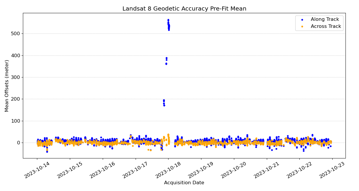
On October 17, 2023, Landsat 8 experienced a Global Positioning System (GPS) fault trip that introduced an along track positional error of up to approximately 1.16 kilometer (km). While science imaging continued normally and radiometry remained unaffected, geometric accuracy was impacted.
To allow Level-1 precision terrain corrected (L1TP) processing during the affected period, updates were made to the Calibration Parameter File (CPF). These adjustments increased the allowable pre-fit Root Mean Square Error (RMSE) thresholds from 200 m to 1,500 m and expanded the maximum allowable Ground Control Point (GCP) chip displacement from 8 to 32 pixels (about 960 m). With these temporary changes in place, data from Paths 64, 80, and 96 were successfully processed and released, resulting in 32 L1TP products that otherwise would have been limited to systematic terrain-corrected (L1GT) quality.
Some data, specifically Paths 112 and 128 prior to Row 212, could not be fully corrected using CPF updates alone; they require software modification to relax the correlation search windows before L1TP processing can proceed. Additionally, several Path 96 scenes acquired between October 17–18 were later found to contain quality issues; these Level-1 and Level-2 products were removed and will be reprocessed once the software changes are implemented.
Radiometric calibration was unaffected by the anomaly, and routine monitoring confirms that no radiometric CPF adjustments were required. Overall, the CPF updates enable continued delivery of high-quality geometric products while long-term processing improvements are implemented.
April 1, 2022 - TIRS Radiometric Gains Return to Quarterly Updates
Recent analysis of Landsat 8 Thermal Infrared (TIRS) performance has shown that the sensor’s responsivity degradation has slowed enough to allow a transition from monthly to quarterly Calibration Parameter File (CPF) updates. Monthly updates were originally required beginning in early 2021 to keep radiometric error within 0.5% following the November 2020 safehold events, after which detector behavior changed more rapidly. Over time, however, the rate of degradation has steadily decreased. By early 2022, three-month responsivity changes were well below 0.5%, making quarterly updates sufficient to maintain radiometric accuracy.
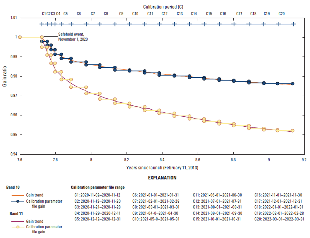
Model assessments and scene level testing confirmed that quarterly predicted gains perform well across both Band 10 and Band 11. Differences between measured and predicted gain values remained small at the start, midpoint, and end of each quarter. A test CPF built for the 1st quarter of 2022 showed maximum scene level differences under roughly 0.05%, with no meaningful change in striping or detector level noise patterns. While some minor impacts were observed in Band 10 jumper correction due to the longer CPF timespan, these effects were manageable and did not compromise product quality.
July 1, 2021 - All Landsat 8 OLI bands adjusted
On July 1, 2021, an adjustment of about 0.1% was applied to all Landsat 8 Operational Land Imager (OLI) bands to account for subtle response changes resulting from the November 2020 safehold events. This adjustment ensures consistent absolute radiometric calibration for both forward processing and for historical OLI data.
December 10, 2020 - Landsat Collection 2 Released
Landsat Collection 2 introduces significant improvements to both radiometric and geometric processing to enhance data accuracy and long-term consistency. Radiometric upgrades include improved calibration models across Landsat 4–8, which reduce instrument drift and strengthen absolute and relative radiometric stability. Enhanced pixel level Quality Assessment information provides more detailed radiometric flags, enabling users to better evaluate pixel reliability. Additionally, Collection 2 incorporates an updated global radiometric reference, improving cross mission harmonization. These foundational enhancements support the production of higher quality Level 2 surface reflectance and surface temperature products spanning nearly four decades.

On the geometric side, Collection 2 delivers a major increase in geolocation accuracy through the integration of a new, high precision global ground control database. This significantly reduces positional errors — sometimes by tens of meters — especially in regions where ground control was previously sparse. Updated global digital elevation models, such as Shuttle Radar Topography Mission (SRTM), NASA Digital Elevation Model (NASADEM), ArcticDEM, and Copernicus, further improve terrain correction by minimizing distortion and parallax effects. Legacy missions (Landsat 4–7) now benefit from modernized geometric correction models that enhance band registration, alignment, and multitemporal consistency.
Together, these radiometric and geometric enhancements create a fully standardized processing approach across the Landsat archive from 1982 to the present. Users benefit from improved interoperability, more stable long-term time series results, and reduced scene-to-scene inconsistencies — making Collection 2 a major advancement for scientific research, environmental monitoring, and operational applications.
December 9, 2020 - Landsat 8 CPF Update After November 2020 Safehold Events
Landsat 8 experienced two safehold events on November 1 and November 12 in 2020.
The November 1st event was triggered by a double fault in the inertial measurement unit (IMU), causing both the Operational Land Imager (OLI) and Thermal Infrared Sensor (TIRS) instruments to automatically power down and to not maintain their nominal thermal environments. The November 12th event was triggered by a boresight fault as the spacecraft entered eclipse while activating its Field of View, also causing both the OLI and TIRS instruments to automatically power down.
Because these safeholds occurred close together, recovery was more complex and instrument temperatures, electronics, and calibration reference points all needed time to stabilize. Instrument initialization was completed November 13, and imaging resumed November 14 following a structured calibration and data collection plan. Because safehold events power down the instruments, complete revalidation of radiometry, geometry, detector performance, and alignment is necessary, and requires an updated Calibration Parameter File (CPF).
Initial post-safehold assessments showed small deviations in OLI and TIRS responses — well within acceptable ranges but still requiring confirmation. Imagery collected immediately after the event was flagged as engineering data until detector maps, geometric integrity, radiometric stability, and relative gain performance were verified. To resume Landsat 8 Real-time product generation, validated instrument parameters had to be incorporated into a new CPF.
The CPF was released on November 19, 2020 and included updated TIRS relative gains derived from pre-safehold Blackbody data, reducing striping observed after the November 1 event. It also carried forward OLI relative gains from a November 6 diffuser collect, as no post-safehold data suggested the need for new updates. Geometric performance for both instruments remained nominal, so no geometric changes were required. Final post-safehold CPFs were issued on December 9, enabling all data acquired since November 1 to be fully reprocessed to Tier 1/2 Level-1 products.
December 15, 2019 - Landsat 8 TIRS Absolute Radiometric Calibration Update
In preparation of Landsat Collection 2 processing, the radiometric calibration of both Landsat-8 TIRS bands will be updated. This update affects data across the lifetime of the mission, but there is one correction for the period from launch to March 2, 2015 (instrument operating on side A electronics) and one correction for data collected after March 2, 2015 (instrument operating on side B electronics).
Prior to the implementation of stray light correction in Collection 1 data processing in early 2017, the radiometric calibration errors were driven by stray light. Once this stray light correction was in place, it became possible to work on reducing any remaining radiometric calibration errors. Vicarious calibration teams with NASA/Jet Propulsion Laboratory and Rochester Institute of Technology have been evaluating the calibration in both bands (Barsi, 2014). These vicarious calibrations used instrumented buoys in various water bodies and covered temperatures from ~275 K to ~300 K. After assembling the lifetime of vicarious calibration results, the calibration team determined that the absolute calibration for both bands should be updated.
The TIRS instrument was calibrated on both electronics sides prior to launch (Montanaro, 2014). These pre-launch calibration parameters have been used to convert the raw image data to radiance since the stray light correction was implemented (the initial correction for an average error introduced by stray light that was applied in the processing system in 2014 was removed with the Collection 1 implementation of the comprehensive stray light correction (Barsi, 2014)). This calibration update modifies the calibration parameters to account for the errors detected by the vicarious calibration. The calibration update is a linear gain and bias adjustment.
The table below lists the estimated change in response as a result of the calibration update in temperature units for each band at a range of temperatures that is being corrected. The figures below plot the errors in temperature and radiance per-band. The calibration parameters have been adjusted to remove these errors, and Landsat 8 TIRS data processed into Collection 2 (estimated to begin in March of 2020) will contain updated radiometric calibration.
| Temperature (K) | TIRS Band 10 Change in Response (K) | TIRS Band 11 Change in Response (K) | ||
| Feb 11, 2013 - Mar 1, 2015 Side A | Mar 2, 2015 - Present Side B | Feb 11, 2013 - Mar 1, 2015 Side A | Mar 2, 2015 - Present Side B | |
| 240 (extrapolated) | -0.11 | 2.73 | -0.89 | 3.16 |
| 273 | 0.08 | 1.05 | -0.66 | 0.80 |
| 285 | 0.14 | 0.60 | -0.61 | 0.15 |
| 300 | 0.20 | 0.12 | -0.56 | -0.58 |
| 320 (extrapolated) | 0.27 | -0.42 | -0.51 | -1.44 |
The estimated change in response as a result of the calibration update for each TIRS band at a range of temperatures for both operational mode of the instrument. The error is significantly more signal-dependent on Side-B. Positive errors indicate the Collection 1 response is too hot, negative errors indicate the Collection1 response is too cold. The estimates for 240 and 320K are extrapolated outside of the temperature range over which the calibration correction was derived.

Montanaro, M.; Lunsford, A.; Tesfaye, Z.; Wenny, B.; Reuter, D. Radiometric Calibration Methodology of the Landsat 8 Thermal Infrared Sensor. Remote Sens. 2014, 6, 8803-8821.
Barsi, J.A.; Schott, J.R.; Hook, S.J.; Raqueno, N.G.; Markham, B.L.; Radocinski, R.G. Landsat-8 Thermal Infrared Sensor (TIRS) Vicarious Radiometric Calibration. Remote Sens. 2014, 6, 11607-11626.
Sept-Dec 2019 - Landsat 8 OLI Scenes Acquired in Lower Truncation Mode
From September to December 2019, a number of scenes are being acquired in lower truncation mode.
Visit the Landsat 8 OLI Lower Truncation webpage to learn more.
April 25, 2017 - OLI Radiometric Calibration Updates for Collection 1 Processing
The absolute radiometric calibration of the Landsat 8 Operational Land Imager (OLI) was updated in February 2017 to reflect changes seen in the instrument’s response to the on-board calibrators indicating a change in the instrument. The response of the Coastal/Aerosol (CA) band has been slowly decreasing since launch. There was a steep decline initially, but that leveled off since the first half-year on orbit to about 0.1% per year (See figure below). There was also a short period of time after the spacecraft went into safehold in September 2013 when the responses of all the VNIR bands (except the NIR band) changed by a small amount (Table 1) then recovered after about 30 days. The second figure below shows the magnitude of the changes relative to the previous absolute calibration.


The magnitude of the gain change for the bands that were affected by the spacecraft safehold event in September-October 2013 are listed below:
Band — Gain Change (percent difference from previous gain)
Blue — 0.175
Green — 0.143
Red — 0.076
NIR — 0.0
Pan — 0.095
Reference: Esad Micijevic; Md. Obaidul Haque; Nischal Mishra; Radiometric calibration updates to the Landsat collection. Proc. SPIE 9972, Earth Observing Systems XXI, 99720D (September 19, 2016); https://doi.org/10.1117/12.2239426.
April 25, 2017 - TIRS Stray Light Correction Implemented in Collection 1 Processing
Stray light from far out-of-field has affected the Landsat 8 Thermal Infrared Sensor (TIRS) absolute calibration since launch. An attempt to correct for it was made in January 2014 (see calibration notice from January 29, 2014) but work continued to develop a real model of the stray light effect in the telescope. An algorithm was developed and implemented into the processing system in February 2017.
The out-of-field source of the stray light was determined based on scans of the moon and tests of a spare telescope in the lab. In general, light was impinging on the detectors from a ring about 13 degrees outside of the field of view. Each TIRS detector is affected differently so a stray light source model was generated for every TIRS detector. On-orbit, the source of the stray light from all locations is not known, but the stray light correction algorithm uses the radiance at the edge of the image as an approximation for what might be out of view (See figure below).
Vicarious calibration data over large water bodies were used to assess the stray light corrected image data. Initial results indicate significant improvement in the absolute accuracy of both TIRS bands. Errors were reduced from 2.1K @ 300K with no correction to 0.3K with the stray light correction for Band 10 and from 4.4K to 0.19K for Band 11. Variability of these errors is reduced as well, from 0.87K to 0.52K at 300K for Band 10 and from 1.67K to 0.91K at 300K for Band 11.
Additional work is underway to assess whether this correction is adequate for use with the split-window atmospheric correction technique. Until that work is complete, it is not recommended that Band 11 be used for the split-window technique.

The source of the stray light is within the TIRS interval to the north and south of the detector, but to the east the stray light originates from outside the sensor’s field-of-view (also to the west, though this particular detector is not affected by stray light to the west). For the locations that fall within the FOV, the TIRS scene radiance is used as the stray light radiance. For the locations that fall outside the FOV, the radiances at the edge of the scene are used as a surrogate for the actual source. This assumes that the radiances at the scene edges are roughly correlated to the radiance field outside the FOV. (Gerace and Montanaro, 2017)
Reference: Aaron Gerace, Matthew Montanaro, Derivation and validation of the stray light correction algorithm for the thermal infrared sensor onboard Landsat 8, Remote Sensing of Environment, Volume 191, 15 March 2017, Pages 246-257, ISSN 0034-4257, https://doi.org/10.1016/j.rse.2017.01.029.
September 2015 - Landsat 8 OLI Scenes Acquired in Lower Truncation Mode
In 2015, the scenes acquired were used to investigate the value of the lower two bits and support the possibility of downloading all 14 bits of data for Landsat 9.
Visit the Landsat 8 OLI Lower Truncation webpage to learn more.
May 8, 2015 - Landsat 8 TIRS Scene Select Mechanism (SSM) Anomaly
On March 6, 2015 the Landsat 8 Thermal Infrared Sensor (TIRS) switched from A side to B side electronics to resolve a problem with the A side encoder electronics. At that time, a plan was outlined for reprocessing data acquired since the problem began.
Beginning April 30, 2015, Landsat 8 scenes acquired from December 19, 2014 to March 13, 2015 began reprocessing to repopulate the TIRS data in the products. This calibration notice details the data changes during this timeframe. The reprocessing effort is expected to complete by May 18, 2015.
Some TIRS data for a number of scenes will not be processed due to non-nominal instrument configuration. There were several intervals identified that the data was good for a portion of the interval, but where the SSM was commanded to rotate off nadir making the TIRS data unusable for the other portion of the interval. The reprocessing will process those where TIRS was well outside the field of view of OLI due to an off nadir SSM as OLI only products.
The table below identifies the reprocessing specifics for the anomaly period.
| TIRS Scene Select Mechanism (SSM) encoder anomaly reprocessing | ||||
| Acquisition Date Range | Sensor Acquired | Current Status | Reprocessing Event | End State |
| December 19, 2014 - March 1, 2015 | OLI & TIRS | Side A TIRS data are currently zeroed out (black) | Scenes will be reprocessed to include valid TIRS bands. | OLI & TIRS data available with some exceptions (see below) |
| January 30, 2015 | OLI & TIRS | TIRS Path 14 Rows 40-121 SSM off nadir | Reprocess as OLI Only | OLI only data available |
| February 2, 2015 | OLI & TIRS | TIRS Path 35 Rows 13-43 SSM off nadir | Reprocess as OLI Only | OLI only data available |
| February 10, 2015 | OLI & TIRS | TIRS Paths 11,27,43,59,75,91 SSM off nadir | Reprocess as OLI Only | OLI only data available |
| February 11, 2015 | OLI & TIRS | TIRS Paths 2, 6,18,34,50,82, 107,123,139, 155,171,187, 203, 219 SSM off nadir | Reprocess as OLI Only | OLI only data available |
| February 19, 2015 | OLI & TIRS | TIRS Path 21 Rows 28 - 50 SSM off nadir | Reprocess as OLI Only | OLI only data available |
| March 2, 2015 - March 3, 2015 | None | No TIRS or OLI imagery acquired due to TIRS side-swap activities | Nothing to reprocess | No Data |
| March 3, 2015 - March 4, 2015 | OLI | OLI-only imaging resumes | Nothing to reprocess | OLI only data available |
| March 4, 2015 | OLI & TIRS | Side B TIRS Paths 5,94,110,126,142,158,174, 190,206,222 SSM off nadir | Reprocess as OLI Only | OLI only data available |
| March 4, 2015 - March 7, 2015 | OLI & TIRS | Side B TIRS data are currently zeroed out (black) | Scenes will be reprocessed to include valid TIRS data. | OLI & TIRS data available |
| March 7, 2015 - March 13, 2015 | OLI & TIRS | Nominal TIRS data | Nothing to reprocess | OLI & TIRS data available |
The Calibration Parameter Files (CPF) for the anomaly period have updated UT1-UTC parameters which may have a slight improvement to OLI and TIRS bands within L1GT products of less than 3 meters. From December 19th 2014 to March 7th 2015 there were no TIRS calibration collections and therefore TIRS data for that period were processed using nominal pre-anomaly calibration parameters. This may cause a slight degradation in thermal measurements but worst case errors are estimated at 0.2 K when viewing a 300 K target. The errors introduced by not having calibration collects for this period of time are much smaller than the errors introduced by TIRS stray light, which can reach up to 2 to 4 K.
Several intervals were identified as having a single event which could cause an anomaly within the imagery. During the acquisition of these intervals the Mission Operations Center issued commands to switch modes of operation on the SSM and a movement of the SSM occurred. These data will be processed as nominal however the TIRS quality score will be lowered to an 8 from the nominal 9 indicating a lower quality. The images below are examples where the mode of operation was changed within a scene causing a small anomaly visible in the TIRS data. There are 8 similar occurrences but each are different in location, and appearance.


January 29, 2014 - Landsat 8 Reprocessing to Begin February 3, 2014
On February 3, 2014, the entire Landsat 8 archive will be cleared from the online cache and reprocessed to take advantage of calibration improvements identified during its first year of operation. All Landsat 8 scenes will be removed from the online cache at this time and these data will be reprocessed starting with the most recent acquisitions and proceeding back to the beginning of the mission. Data will then become available for download. Scenes waiting to be reprocessed will also be available for on-demand product orders. Reprocessing is expected to take approximately 50 days.
The Operational Land Imager (OLI) and Thermal Infrared Sensor (TIRS) instruments onboard the satellite have proven to be outstanding sensors; however, all sensors have required radiometric and geometric refinements to ensure good calibration and data continuity. This reprocessing campaign includes all previously implemented calibration parameter updates implemented since launch. These changes are described in more detail below.
Changes to Operational Land Imager (OLI) data
All spectral bands of the OLI sensor have shown minor striping, noticeable primarily in dark uniform areas; the striping is worse in coastal aerosol (CA) and short wave infrared (SWIR) bands. Striping has been reduced by making refinements to the detector linearization correction in the Radiometric Look-Up Table (RLUT). The relative radiometric accuracy is improved by this change; however, the absolute accuracy remains unchanged.
An additional change to the relative gains in the Calibration Parameter File (CPF) will be updated to further reduce striping in the cirrus band. This change will not affect the absolute radiometric accuracy.
The OLI radiometric calibration is being updated to reflect better knowledge of the prelaunch test data, on which the original calibration was based. The reflectance will change at most 0.8 percent, except for the cirrus Band 9, which will change by 7.3 percent (see table). This calibration update will make the reflectance appear brighter than when these data were processed with the previous radiometric calibration. These changes apply only to data converted to reflectance. An improvement to the absolute accuracy of the radiance values, around 2 percent for most bands, will also be implemented.
| OLI Bands | Radiance Change (%) | Reflectance Change (%) |
|---|---|---|
| 1 (Coastal Aerosol) | -2.1 | 0.8 |
| 2 (Blue) | -2.0 | 0.4 |
| 3 (Green) | -1.7 | 0.0 |
| 4 (Red) | -1.9 | 0.3 |
| 5 (NIR) | -1.4 | 0.0 |
| 6 (SWIR1) | -2.2 | 0.4 |
| 7 (SWIR2) | 1.5 | 0.5 |
| 8 (Pan) | -1.6 | 0.2 |
| 9 (Cirrus) | 0.7 | 7.3 |
Changes to Thermal Infrared Sensor (TIRS) data
The TIRS temperature offsets noted on November 14, 2013 Calibration Notice is a primary driver for this reprocessing effort.
These offsets remove 0.29 W/m2/sr/um (~2.1 K) from Band 10 and 0.51 W/m2/sr/um (~4.4 K) from band 11, relative to products processed prior to February 3, 2014. The offsets represent an average error introduced by stray light coming from outside the TIRS field of view and will improve the data accuracy for typical growing season data (10° to 30° C) where the surrounding areas are similar in temperature.
The Root Mean Square (RMS) variability of this correction is 0.12 W/m2/sr/um (~0.8 K) for Band 10 and remains greater at 0.2 W/m2/sr/um (~1.75 K) for Band 11. Due to the larger calibration uncertainty associated with Band 11, it is recommended that users refrain from relying on Band 11 data in quantitative analysis of the TIRS data, such as the use of split window techniques for atmospheric correction and retrieval of surface temperature values.
| TIRS Bands | Radiance Offset [W/m2/sr/um] | Temperature Offset [K @ 300K] |
|---|---|---|
| 10 | -0.29 +/- 0.12 | -2.1 +/- 0.8 |
| 11 | -0.51 +/- 0.2 | -4.4 +/- 1.75 |
Geometric Alignment between the Sensors
There are a few geometric changes that will also be fixed in the reprocessing. Based on the analysis of on-orbit data, the alignment between the TIRS instrument and the OLI instrument will be adjusted according to these time periods:
| Effective Date Range | Change in TIRS alignment | Change in TIRS alignment |
|---|---|---|
| Launch- 09/19/2013 | 12 microradians | 8.5 meters |
| 09/20/2013- 09/30/2013 | 25 microradians | 18 meters |
| 10/01/2013- 11/27/2013 | 10 microradians | 7.1 meters |
Geometric alignment changes
There is no change to the TIRS alignment in products after the calibration update on November 27, 2013, which already accounted for this adjustment. These adjustments will improve the alignment of the TIRS thermal bands to the OLI reflective bands.
Due to an apparent seasonal variation in the common alignment of the OLI and TIRS instruments to the Landsat 8 spacecraft attitude control system, a sensor alignment update has been applied to both instruments effective October 1, 2013. The magnitude of this change is approximately 12 microradians (8.5 meters) across track and 8 microradians (6 meters) along track. This change does not impact precision Level-1T (L1T) products (which are corrected using ground control points) but will change the geolocation of systematic Level-1GT (L1GT) products.
New Ground Control Points (GCPs) will become available for three WRS-2 path/rows and GCPs contained within large water bodies will be removed on February 3, 2014 to coincide with the Landsat 8 archive reprocessing. As a consequence of the improved GCPs, scenes once created as a L1GT product may now process to a L1T product. The January 16, 2014 Calibration notice details this update.
In addition to the details provided above, the changes noted in the January 6, 2014 Calibration Notice will also be included in this reprocessing.
January 23, 2014 - Immediate Landsat 8 TIRS Data Adjustment
An incorrect bias adjustment for Thermal Infrared Sensor (TIRS) data was discovered in the latest release of the Landsat 8 processing system, which has caused a significant error in the TIRS products produced from Landsat 8 scenes acquired from January 14, 2014 to January 23, 2014. (The Operational Land Imager (OLI) bands are not affected.) All Landsat 8 scenes processed between January 14 and January 23 will be purged from the online cache and will become available for on demand order processing. An estimated 3 percent absolute radiometric error is observed and the errors do cause significant striping and banding in bands 10 and 11.
The screenshot below shows a scene processed with the incorrect bias parameters on the left and as it should appear on the right.

January 16, 2014 - New Ground Control Points for Select Landsat 8 Scenes
New Ground Control Points (GCPs) will become available for three WRS-2 path/rows listed below on February 3, 2014 to coincide with the Landsat 8 archive reprocessing:
Path/Row, Location
151/30, Kazakhstan/Kyrgyzstan
138/41, Bhutan
172/43, Red Sea
Because these GCPs are more accurate than previous versions, users should consider replacing Landsat 8 images downloaded before February 3rd, 2014. It is recommended that previously downloaded images for these paths/rows be re-ordered to employ the new GCPs, as scenes once created as a systematic Level-1GT (L1GT) product may now process to a precision Level-1T (L1T) product.
Additionally, GCPs that were determined to be contained within large bodies of water were removed from use during Level-1 processing. Although the presence of these points typically has little effect on the quality of the geometric registration of the L1T imagery, there have been cases where the removal of these GCPs changes the product type from L1GT to L1T.
January 6, 2014 - Landsat 8 Reprocessing Details
Several calibration parameter updates will be implemented as part of the Landsat 8 data reprocessing on February 3, 2014 that will result in improved product quality. This reprocessing campaign includes all previously implemented calibration parameter updates that have been implemented since launch. These changes are described in more detail below.
The OLI detector linearization correction coefficients have been refined for all spectral bands to decrease striping in imagery over dark uniform areas. The absolute radiometric accuracy is not significantly affected.
The OLI radiance conversion coefficients are also improved slightly by correcting for a slight error in pre-launch calibration that resulted in product radiance values with as much as a +2% error. A slight improvement to the absolute accuracy of the reflectance values, mainly the cirrus band, will also be implemented. The relative gains will also be updated to reduce striping in the cirrus band, but this will not affect the absolute radiometric accuracy.
The previously mentioned TIRS temperature offset (See the November 15, 2013 Notice) will also be implemented on February 3, 2014. These offsets remove 0.29 W/m^2/sr/um from TIRS band 10 and 0.51 W/m^2/sr/um from TIRS band 11, relative to products processed prior to February 3, 2014. These offsets will remove an average error introduced by stray light coming from outside the TIRS field of view and will improve the data accuracy for typical growing season data (10° to 30° C) where the surrounding areas are similar in temperature. The RMS variability of this correction is 0.12 W/m^2/sr/um for TIRS band 10 and but remains greater at 0.2 W/m^2/sr/um for TIRS band 11. Due to the larger calibration uncertainty associated with TIRS band 11, it is recommended that users refrain from relying on band 11 data in quantitative analysis of the TIRS data, such as the use of split window techniques for atmospheric correction and retrieval of surface temperature values.
Based on the analysis of on-orbit data, the alignment between the TIRS instrument and the OLI instrument will be adjusted according to these time periods:
| Effective Date Range | Change in TIRS Alignment (in microradians) |
|---|---|
| Launch - September 19, 2013 | 12 |
| September 20, 2013 - September 30, 2013 | 25 |
| October 1, 2013 - November 27, 2013 | 10 |
There is no change to the TIRS alignment in products after the calibration update on November 27, 2013, which already accounted for this adjustment.
Previous updates included in reprocessing effort:
These changes in calibration were implemented in the past, but data processed prior to these dates was not reprocessed, so scenes processed prior to these dates do not include these updates.
June 28, 2013
Tightened the prelaunch geometric processing thresholds to account for the higher accuracy observed while using the on-orbit geometric calibration derived during the commissioning period.
August 9, 2013
Adjusted the OLI linearity correction coefficients based on analysis of updated pre-launch calibration information which improves the striping at various radiance levels. This update affected all OLI spectral bands with respect to striping, but didn't significantly affect the absolute radiometric accuracy. (See the August 9, 2013 Notice)
August 21, 2013
Improved the geodetic consistency with Landsat 1-7 imagery and reduced striping. (See the August 21, 2013 Notice)
September 27, 2013
Adjusted the TIRS alignment to account for the safe hold anomaly that occurred on September 19, 2013. (See the September 27, 2013 Notice)
November 27, 2013
In addition to the TIRS alignment adjustment shown in the table above, the gains of the detectors on the edges of each sensor chip assembly of the OLI spectral bands was adjusted slightly to reduce the potential stripes. The largest change is less than 0.3%, doesn't affect the overall radiometric accuracy of the products.
November 14, 2013 - Upcoming Change in Landsat 8 Radiometric Calibration (Revision)
The majority of the radiometric calibration changes indicated in the October 25, 2013 calibration notice have been deferred to early-2014, to coincide with a software update for the Landsat Product Generation System (LPGS). Therefore, reprocessing of the entire Landsat 8 archive will not occur before early-2014.
When the reprocessing effort begins, the OLI radiance-to-reflectance conversion coefficients will be adjusted for the cirrus band (Band 9) to account for on-orbit performance. The prelaunch derived coefficients were calculated using heliostat measurements, which were expected to be in error because little sunlight reaches the ground at these wavelengths. This adjustment changes the reflectance by about 7 percent in the cirrus band. Additionally, the precision of the other spectral bands' radiance-to-reflectance conversion coefficients will be increased, changing the reflectance by up to 0.3 percent.
Relating to TIRS thermal band calibration, prior to the early-2014 update, users may subtract 0.29 W/(m2 sr µm) from every TIRS Band 10 calibrated radiance value, and 0.51 W/(m2 sr µm) for every TIRS Band 11 calibrated radiance value to provide values closer (on average) to the actual radiances. The equations to convert from calibrated product pixel values to calibrated radiance values can be found on the Landsat 8 web page. These numbers are based on comparisons to surface water temperatures and correspond to a -2.1 K correction (Band 10) and a -4.4 K correction (Band 11) for a 295 K brightness temperature. The rms variability in the required adjustment is roughly 0.12 W/(m2 sr µm) (0.8 K) for Band 10 and 0.2 W/(m2 sr µm) (1.75 K) for Band 11. Studies indicate that the errors are scene dependent and probably related to out-of-field response in the TIRS instrument.
Given the larger uncertainty in the Band 11 values, users should work with TIRS Band 10 data as a single spectral band (like Landsat 7 Enhanced Thematic Mapper Plus (ETM+)) and should not attempt a split-window correction using both TIRS Bands 10 and 11.
Updates will be provided on this page as understanding of the calibration improves, and also when the reprocessing effort is planned to begin.
October 25, 2013 - Upcoming Change in Landsat 8 Radiometric Calibration
In the near future, calibration changes will be made that will affect the Thermal Infrared Sensor (TIRS) Band 10 and all of the Operational Land Imager (OLI) bands onboard Landsat 8.
The calibration for TIRS Band 10 will be lowered by a constant 0.32 W/(m2 sr µm) for every TIRS Band 10 pixel. This adjustment is being made due to significant discrepancies as compared to surface water temperature measurements. Studies are ongoing to better characterize the source of the calibration errors, and if possible, provide a more accurate scene-dependent correction. No adjustment will be made to TIRS Band 11, as indications are that its calibration is further off and more variable. Until indicated otherwise, users should work with TIRS Band 10 data as a single spectral band (like Landsat 7 Enhanced Thematic Mapper Plus (ETM+)) and should not attempt a split-window correction using both TIRS Bands 10 and 11.
Prior to this reprocessing effort, users can subtract 0.32 W/(m2 sr µm) from the TIRS Band 10 Top-of-Atmosphere (TOA) radiance data to improve the accuracy of their current image products or to avoid downloading a new image product after reprocessing occurs. Once a more accurate scene-dependent correction is determined, a second purge and reprocessing will take place.
The OLI radiance-to-reflectance conversion coefficients will be adjusted for the cirrus band (Band 9) to account for on-orbit performance. The prelaunch derived coefficients were calculated using heliostat measurements, which were expected to be in error because little sunlight reaches the ground at these wavelengths. This adjustment changes the reflectance by about 7 percent in the cirrus band. Additionally, the precision of the other spectral bands' radiance-to-reflectance conversion coefficients will be increased, changing the reflectance by up to 0.3 percent.
The relative gains of single detectors on the edges of each OLI Sensor Chip Assembly (SCA) will be updated to correct slight striping that is typically not visible. This update will affect all OLI spectral bands.
September 27, 2013 - Landsat 8 CPF Update for Offset Following Safehold
On September 19, 2013 (DOY 262) at approximately 20:08 UTC, Landsat 8 experienced an unplanned transition to safe hold following an attitude control anomaly. Precision attitude control was recovered and imaging operations resumed on day of year 264 (September 21, 2013). Post-anomaly calibration checks detected a systematic change in the alignment between the OLI and TIRS sensors. No change in the OLI alignment to the spacecraft attitude control system was apparent so the shift is being attributed to the TIRS instrument.
The magnitude of the change - a pitch axis offset of approximately 30 microradians (about 0.2 TIRS pixels) - is large enough to threaten the thermal-to-reflective band registration requirements. Band registration tests confirm that the along-track TIRS-to-OLI band registration performance has been degraded since the safe hold event.
A calibration parameter file (CPF) update to the ACS_to_TIRS_Rotation_Matrix parameter was developed to correct this offset and was put into production on September 27, 2013. This update is effective from September 21, 2013, so a subdivision of the 3rd quarter CPF effective date range will be required. The new parameters will also be used for the upcoming 4th quarter CPF unless the ongoing monitoring of TIRS-to-OLI alignment indicates that further changes are required.
No direct cause for the alignment change is known but it may be related to the change in the spacecraft thermal environment during the safe hold period. If this is the case, it is possible that, over time, the alignment will drift back closer to its earlier position.
August 22, 2013 - Landsat 8 Thermal Infrared Sensor (TIRS) Calibration Notice
Discrepancies have been noted between calibrated Landsat 8 TIRS Bands 10 and 11 data, and surface-water temperature measurements collected to validate thermal band calibration.
Surface-water temperatures derived from TIRS data, after correction for atmospheric transmission and emissivity, are warmer than measured surface-water temperatures by 2K or more. These discrepancies also may not be consistent across the focal plane. This indicates a possible bias or other error in TIRS calibration that places the calibration uncertainty beyond the specified performance of 2 percent.
Users are cautioned to be aware of potential impacts to their analyses and results. The calibration team continues to analyze TIRS data and compare results to surface-water temperature measurements to discover the source of the discrepancy.
Updates to TIRS calibration coefficients will be incorporated into Landsat 8 data processing as soon as the discrepancy is sufficiently understood. Details will be provided on this website as they become available.
August 21, 2013 - Landsat 8 CPF Update Improves Geodetic Consistency with Landsat 1-7 Imagery and Decreases Striping
An update to the CPF on August 21, 2013 improves the geodetic consistency with Landsat 1-7 imagery. Due to some GLS 2000 scenes having significant geodetic errors, a limit is set between the systematically corrected product and the GLS 2000 reference. This limit has been increased from 100 meters and is now set at 200 meters. Scenes with a difference less than 200 meters will be consistent with historical Landsat imagery. There are no known GLS 2000 reference scenes that are off more than 200 meters.
This update also improves the OLI relative calibration which reduces striping in very uniform scenes. The largest improvement is in the Coastal Aerosol (Band 1) where the magnitude of the striping is largest (see figures below), but all reflective bands are affected. The radiometric accuracy has not been affected since these changes are relative to the existing absolute calibration. The banding visible in the figures below is not affected, but will be addressed in a future calibration update.


August 9, 2013 - Landsat 8 RLUT Update Decreases Striping
Response Linearization Look Up Tables (RLUT) are additional files that accompany Calibration Parameter Files (CPF) and contain parameters used to linearize the output of the OLI detectors. This is done to correct the relationship between Digital Number (DN) values and the dynamic range of the instrument. Linearization also helps to limit saturated pixels to true saturations, and on the dark end, limit zero values to missing data.
An update to the RLUT on August 9, 2013 decreases the striping that was initially seen within the Coastal Aerosol (Band 1), SWIR1 (Band 6), and SWIR2 (Band 7) spectral bands of some Landsat 8 scenes (see figures below).
The magnitude of these stripes is small and vary based on the brightness of the scene. This improvement will be seen in very uniform areas; however this update may increase the striping and banding slightly in extremely uniform areas of very low reflectance scenes ( < 0.1% reflectance; see figure below). This will be corrected with a future system release.


May 14, 2013 - Landsat 8 OLI Scenes Acquired in Lower Truncation Mode During On-orbit Checkout Period
In 2013, 440 scenes were acquired in lower truncation mode during Landsat 8's on-orbit checkout period prior to data becoming available to all users.
Visit the Landsat 8 OLI Lower Truncation webpage to learn more.