
Landsat 9 captured this image of heart-shaped McCartney Mountain on September 20, 2025. At an elevation of over 8,300 feet, the mountain is the high point of a small sub-range of the Highland Mountains in southwestern Montana.
What are Landsat Bulk Metadata Parquet Files?
The Landsat Bulk Metadata Service is comprised of files that list all available Landsat Level-1, Level-2, and U.S. Analysis Ready Data products contained in the USGS EROS archive. The files include millions of records from more than 53 years of data and are updated daily.
Since the files contain so much information, they can be very large. This can make them difficult to open or work with using standard computer programs.
Apache Parquet files store data in a format designed to make large datasets easier and faster to use. They offer several benefits:
- Smaller file sizes. A CSV file that is 3 GB may shrink to about 700 MB when saved as a Parquet file.
- Faster searches. You can pull only the information you need, such as cloud cover or image date, without opening the entire file.
- Better data analysis. Parquet files work well with programming languages such as Python and R, which helps speed up analysis.
- Compatible with big-data tools. Parquet files work with analytics and processing systems such as Tableau, Apache Spark, Hadoop, and cloud platforms.
- Flexible updates. New data can be added to Parquet files without breaking existing workflows.
Learn more:
Related

How can I bulk download USGS Earth Resources Observation and Science (EROS) products? How can I bulk download USGS Earth Resources Observation and Science (EROS) products?
The Bulk Download Web Application (BDWA ) lets users download large amounts of satellite, aerial imagery and other geospatial data. A video " Using the EarthExplorer BDWA," explains how to add scenes through EarthExplorer and retrieve them with minimal user interaction. An April 2023 webinar, " The New and Improved Bulk Download Web Application," also provides an overview of the tool. To receive...

How do I search for and download Landsat data? How do I search for and download Landsat data?
Landsat data products held in the USGS archives can be searched and downloaded at no charge from a variety of sources. Visit Landsat Data Access for information about how Landsat data products can be downloaded individually or in bulk. Landsat imagery not found in the USGS archive might have been collected by one of the USGS International Cooperator ground stations, each of which are the primary...

What Landsat products are available? What Landsat products are available?
There are several Landsat Collection 2 products that are useful for science applications and land use/land change studies: Landsat Level-1 Products - Each Level-1 product includes individual spectral band files, a metadata file, and additional ancillary files. Level-1 products are available for all global landmasses. Landsat U.S. Analysis Ready Data (ARD) - U.S. ARD uses Landsat Level-1 data as...

Are Landsat data in the cloud still considered to be within the public domain? Are Landsat data in the cloud still considered to be within the public domain?
Yes. Regardless of where the USGS has stored the files, Landsat data are controlled by the USGS and considered to be an official USGS record in the public domain. Permission is not required for use. We do request that you acknowledge the USGS as the source. Learn More: USGS Copyrights and Credits statement Landsat Commercial Cloud Data Access

What are Landsat Collections? What are Landsat Collections?
In 2016, the USGS reorganized the Landsat archive into a tiered collection. This structure ensures that Landsat Level-1 products provide a consistent archive of known data quality to support time-series analyses and data “stacking”, while controlling continuous improvement of the archive and access to all data as they are acquired. Learn more: Landsat Collections Landsat Data Access
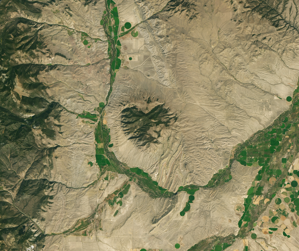
Landsat 9 Image of McCartney Mountain
Landsat 9 captured this image of heart-shaped McCartney Mountain on September 20, 2025. At an elevation of over 8,300 feet, the mountain is the high point of a small sub-range of the Highland Mountains in southwestern Montana.

Landsat 8 Color Infrared Image of Lake Tahoe
This image of Lake Tahoe, California displays the landscape's vegetation properties in shades of red. This image was created using Bands 5,4, and 3 from data acquired by Landsat 8 on February 13, 2022.
This image of Lake Tahoe, California displays the landscape's vegetation properties in shades of red. This image was created using Bands 5,4, and 3 from data acquired by Landsat 8 on February 13, 2022.

Landsat 1 image of Seattle, Tacoma Washington Area 1973
Landsat 1 image of Seattle, Tacoma Washington Area 1973This satellite image of the Seattle, Tacoma Washington area was acquired by the Landsat 1 Multispectral Scanner (MSS) on September 16, 1973.
Path 50, Row 27
Visit the Landsat Missions Web Site to learn more about the Landsat satellites that have been acquiring data of the Earth since 1972.

First Landsat 7 image of Sioux Falls, South Dakota
First Landsat 7 image of Sioux Falls, South DakotaThis pan sharpened color infrared image of Sioux Falls, South Dakota is from the first scene acquired by Landsat 7's Enhanced Thematic Mapper Plus (ETM+) sensor on April 18, 1999. The image is shown using the near infrared, red, and green bands (Bands 4,3,2).

Landsat 5 First Light Image of Corpus Christi, Texas
Landsat 5 First Light Image of Corpus Christi, TexasOn March 6, 1984, the Thematic Mapper (TM) on Landsat 5 captured this image of Corpus Christi. Texas. Located in South Texas on the Gulf of America, the city and its bay are protected by barrier islands.

Landsat 4 First Light Image of Detroit
The first Landsat 4 image was acquired over western Lake Erie on July 25, 1982, just 9 days after launch. This image shows the Detroit River dividing the metropolitan areas of Detroit, Michigan and Windsor, Ontario while acting as a strait between Lake Erie and Lake St. Clair.
The first Landsat 4 image was acquired over western Lake Erie on July 25, 1982, just 9 days after launch. This image shows the Detroit River dividing the metropolitan areas of Detroit, Michigan and Windsor, Ontario while acting as a strait between Lake Erie and Lake St. Clair.

Landsat 3 First Light Image of San Jose
Landsat 3’s first image features a slice of Northern California on March 7, 1978.
Landsat 3’s first image features a slice of Northern California on March 7, 1978.
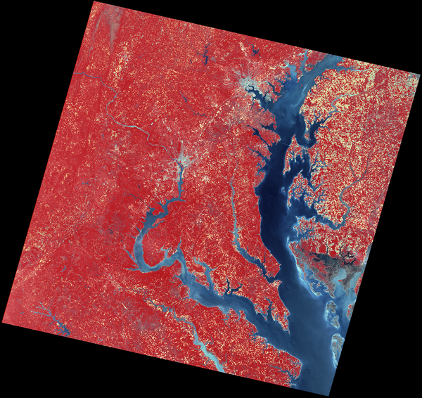
Landsat 2 image of Washington DC and Baltimore area
Landsat 2 image of Washington DC and Baltimore areaThe Multispectral Scanner (MSS) onboard the Landsat 2 satellite captured the data used to create this color infrared image on May 15,1975. Chesapeake Bay leads up the image to Baltimore, Maryland, and the Potomac River leads west and north up to Washington, DC.
Related
How can I bulk download USGS Earth Resources Observation and Science (EROS) products? How can I bulk download USGS Earth Resources Observation and Science (EROS) products?
The Bulk Download Web Application (BDWA ) lets users download large amounts of satellite, aerial imagery and other geospatial data. A video " Using the EarthExplorer BDWA," explains how to add scenes through EarthExplorer and retrieve them with minimal user interaction. An April 2023 webinar, " The New and Improved Bulk Download Web Application," also provides an overview of the tool. To receive...
How do I search for and download Landsat data? How do I search for and download Landsat data?
Landsat data products held in the USGS archives can be searched and downloaded at no charge from a variety of sources. Visit Landsat Data Access for information about how Landsat data products can be downloaded individually or in bulk. Landsat imagery not found in the USGS archive might have been collected by one of the USGS International Cooperator ground stations, each of which are the primary...
What Landsat products are available? What Landsat products are available?
There are several Landsat Collection 2 products that are useful for science applications and land use/land change studies: Landsat Level-1 Products - Each Level-1 product includes individual spectral band files, a metadata file, and additional ancillary files. Level-1 products are available for all global landmasses. Landsat U.S. Analysis Ready Data (ARD) - U.S. ARD uses Landsat Level-1 data as...
Are Landsat data in the cloud still considered to be within the public domain? Are Landsat data in the cloud still considered to be within the public domain?
Yes. Regardless of where the USGS has stored the files, Landsat data are controlled by the USGS and considered to be an official USGS record in the public domain. Permission is not required for use. We do request that you acknowledge the USGS as the source. Learn More: USGS Copyrights and Credits statement Landsat Commercial Cloud Data Access
What are Landsat Collections? What are Landsat Collections?
In 2016, the USGS reorganized the Landsat archive into a tiered collection. This structure ensures that Landsat Level-1 products provide a consistent archive of known data quality to support time-series analyses and data “stacking”, while controlling continuous improvement of the archive and access to all data as they are acquired. Learn more: Landsat Collections Landsat Data Access
Landsat 9 Image of McCartney Mountain
Landsat 9 captured this image of heart-shaped McCartney Mountain on September 20, 2025. At an elevation of over 8,300 feet, the mountain is the high point of a small sub-range of the Highland Mountains in southwestern Montana.
Landsat 9 captured this image of heart-shaped McCartney Mountain on September 20, 2025. At an elevation of over 8,300 feet, the mountain is the high point of a small sub-range of the Highland Mountains in southwestern Montana.
Landsat 8 Color Infrared Image of Lake Tahoe
This image of Lake Tahoe, California displays the landscape's vegetation properties in shades of red. This image was created using Bands 5,4, and 3 from data acquired by Landsat 8 on February 13, 2022.
This image of Lake Tahoe, California displays the landscape's vegetation properties in shades of red. This image was created using Bands 5,4, and 3 from data acquired by Landsat 8 on February 13, 2022.
Landsat 1 image of Seattle, Tacoma Washington Area 1973
Landsat 1 image of Seattle, Tacoma Washington Area 1973This satellite image of the Seattle, Tacoma Washington area was acquired by the Landsat 1 Multispectral Scanner (MSS) on September 16, 1973.
Path 50, Row 27
Visit the Landsat Missions Web Site to learn more about the Landsat satellites that have been acquiring data of the Earth since 1972.
First Landsat 7 image of Sioux Falls, South Dakota
First Landsat 7 image of Sioux Falls, South DakotaThis pan sharpened color infrared image of Sioux Falls, South Dakota is from the first scene acquired by Landsat 7's Enhanced Thematic Mapper Plus (ETM+) sensor on April 18, 1999. The image is shown using the near infrared, red, and green bands (Bands 4,3,2).
Landsat 5 First Light Image of Corpus Christi, Texas
Landsat 5 First Light Image of Corpus Christi, TexasOn March 6, 1984, the Thematic Mapper (TM) on Landsat 5 captured this image of Corpus Christi. Texas. Located in South Texas on the Gulf of America, the city and its bay are protected by barrier islands.
Landsat 4 First Light Image of Detroit
The first Landsat 4 image was acquired over western Lake Erie on July 25, 1982, just 9 days after launch. This image shows the Detroit River dividing the metropolitan areas of Detroit, Michigan and Windsor, Ontario while acting as a strait between Lake Erie and Lake St. Clair.
The first Landsat 4 image was acquired over western Lake Erie on July 25, 1982, just 9 days after launch. This image shows the Detroit River dividing the metropolitan areas of Detroit, Michigan and Windsor, Ontario while acting as a strait between Lake Erie and Lake St. Clair.
Landsat 3 First Light Image of San Jose
Landsat 3’s first image features a slice of Northern California on March 7, 1978.
Landsat 3’s first image features a slice of Northern California on March 7, 1978.
Landsat 2 image of Washington DC and Baltimore area
Landsat 2 image of Washington DC and Baltimore areaThe Multispectral Scanner (MSS) onboard the Landsat 2 satellite captured the data used to create this color infrared image on May 15,1975. Chesapeake Bay leads up the image to Baltimore, Maryland, and the Potomac River leads west and north up to Washington, DC.
Updated Date: July 1, 2026