
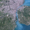
Landsat 4 First Light Image of Detroit

Detailed Description
The first Landsat 4 image was acquired over western Lake Erie on July 25, 1982, just 9 days after launch. This image shows the Detroit River dividing the metropolitan areas of Detroit, Michigan and Windsor, Ontario while acting as a strait between Lake Erie and Lake St. Clair.
Although the Landsat program had been collecting images of the Earth since 1972, this was the first time that the data could be depicted as a natural color image due to the new Thematic Mapper sensor onboard Landsat 4. The Thematic Mapper not only had an increased spectral resolution but an improved geometric resolution as well.
Learn more about the mission by visiting the Landsat 4 web page
Sources/Usage
Public Domain.
Related

Landsat 4 First Light Image over western Lake Erie
Landsat 4's first light image captured eastern Lake Erie, and the cities of Toledo, Detroit, and Windsor on July 25, 1982. Although the Landsat program had been collecting images of the Earth since 1972, this was the first time that the data could be depicted as a natural color image due to the new Thematic Mapper sensor onboard Landsat 4. The Thematic Mapper not only had an increased spectral...
Related
Landsat 4 First Light Image over western Lake Erie
Landsat 4's first light image captured eastern Lake Erie, and the cities of Toledo, Detroit, and Windsor on July 25, 1982. Although the Landsat program had been collecting images of the Earth since 1972, this was the first time that the data could be depicted as a natural color image due to the new Thematic Mapper sensor onboard Landsat 4. The Thematic Mapper not only had an increased spectral...