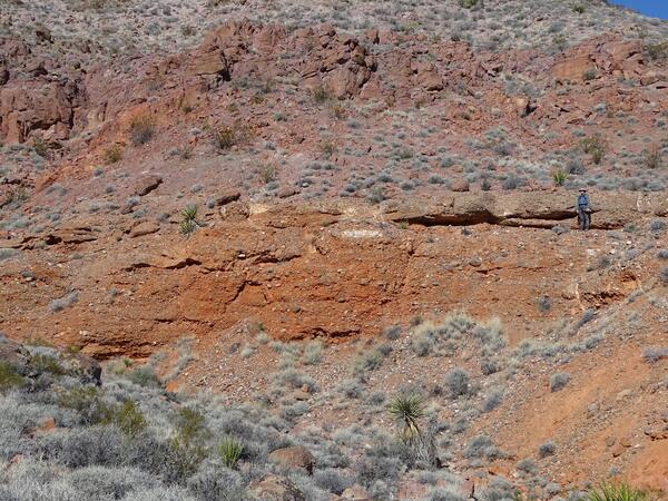
Conglomerates are sedimentary rocks that are made up of various fragments of rock interspersed with finer grained material. This particular conglomerate was deposited as a fan on the northwest side of the Culpeper Basin.
What are sedimentary rocks?
Sedimentary rocks are formed from pre-existing rocks or pieces of once-living organisms. They form from deposits that accumulate on the Earth's surface. Sedimentary rocks often have distinctive layering or bedding. Many of the picturesque views of the desert southwest show mesas and arches made of layered sedimentary rock.
Common Sedimentary Rocks:
Common sedimentary rocks include sandstone, limestone, and shale. These rocks often start as sediments carried in rivers and deposited in lakes and oceans. When buried, the sediments lose water and become cemented to form rock. Tuffaceous sandstones contain volcanic ash.
Clastic Sedimentary Rocks:
Clastic sedimentary rocks are the group of rocks most people think of when they think of sedimentary rocks. Clastic sedimentary rocks are made up of pieces (clasts) of pre-existing rocks. Pieces of rock are loosened by weathering, then transported to some basin or depression where sediment is trapped. If the sediment is buried deeply, it becomes compacted and cemented, forming sedimentary rock. Clastic sedimentary rocks may have particles ranging in size from microscopic clay to huge boulders. Their names are based on their clast or grain size. The smallest grains are called clay, then silt, then sand. Grains larger than 2 millimeters are called pebbles. Shale is a rock made mostly of clay, siltstone is made up of silt-sized grains, sandstone is made of sand-sized clasts, and conglomerate is made of pebbles surrounded by a matrix of sand or mud.
Biologic Sedimentary Rocks:
Biologic sedimentary rocks form when large numbers of living things die. Chert is an example for this type of rock, and this is one of the ways limestone can form. Limestone can also form by precipitating directly out of the water.
Related Content
How did Half Dome, the massive rock monument in Yosemite National Park, acquire its unique shape?
At the head of the valley in Yosemite National Park - as if on a pedestal - stands Half Dome. It is smoothly rounded on three sides and a sheer vertical face on the fourth. Half Dome, which stands nearly 8,800 feet (2,682 meters) above sea level, is composed of granodiorite, and is the remains of a magma chamber that cooled slowly and crystallized thousands of feet beneath the Earth's surface. The...
Is glacier ice a type of rock?
Glacier ice, like limestone (for example), is a type of rock. Glacier ice is actually a mono-mineralic rock (a rock made of only one mineral, like limestone which is composed of the mineral calcite). The mineral ice is the crystalline form of water (H 2 O). Most glacier ice forms through the metamorphism of tens of thousands of individual snowflakes into crystals of glacier ice. Each snowflake is...
What are metamorphic rocks?
Metamorphic rocks started out as some other type of rock, but have been substantially changed from their original igneous , sedimentary , or earlier metamorphic form. Metamorphic rocks form when rocks are subjected to high heat, high pressure, hot mineral-rich fluids or, more commonly, some combination of these factors. Conditions like these are found deep within the Earth or where tectonic plates...
What are igneous rocks?
Igneous rocks (from the Latin word for fire) form when hot, molten rock crystallizes and solidifies. The melt originates deep within the Earth near active plate boundaries or hot spots, then rises toward the surface. Igneous rocks are divided into two groups, intrusive or extrusive, depending upon where the molten rock solidifies. Intrusive Igneous Rocks: Intrusive, or plutonic, igneous rock forms...
Are there geologic maps or publications for where I live?
Detailed geologic mapping has not been completed for the entire United States, but maps are available for most locations. Geologic maps at many scales and from many sources are listed in the National Geologic Map Database . Some geologic maps can be purchased in hard copy through the USGS Store . Download digital geologic maps for entire states from the USGS Mineral Resources Online Geospatial...
Where can I find information about the geology and natural history of National Parks?
Our National Parks are the showcases of our nation's geological heritage. The National Park Service has websites for most individual parks that include information about their geology and natural history. A source of information from the USGS is our Geology and Ecology of National Parks website. The website has listings for regions of the country; selected parks are listed within each region...
What is the difference between a rock and a mineral?
A mineral is a naturally occurring inorganic element or compound having an orderly internal structure and characteristic chemical composition, crystal form, and physical properties. Common minerals include quartz, feldspar, mica, amphibole, olivine, and calcite. A rock is an aggregate of one or more minerals, or a body of undifferentiated mineral matter. Common rocks include granite, basalt...
Conglomerates are sedimentary rocks that are made up of various fragments of rock interspersed with finer grained material. This particular conglomerate was deposited as a fan on the northwest side of the Culpeper Basin.
Exposure of the Marcellus shale in central New York showing the Cherry Valley limestone (grey-colored rock) between the Union Springs and Oatka Creek shales of the Marcellus.
Wind and water combine to create unique patterns in the sandstone.
Detail of the wind and water-weathered sandstone that forms the Beehive Formation in the Valley of Fire Nevada State Park
Views along the Navajo Loop Trail in Bryce Canyon National Park.
Bryce Canyon is a unique sandstone formation in southern Utah. It is home to a large number of hoodoos, which are oddly shaped pillars of rock that formed due to different erosion rates for the dolomite that caps them and the sandstone that forms their base.
Bryce Canyon is also home to large numbers of cedar trees that spread throughout the canyon.
Seeps along limestone outcrop downstream from where Jim John Creek flows into the Colorado River, October 31, 2012 (photograph by Jennifer Wilson, U.S. Geological Survey).
SIR 2015–5098
Seeps along limestone outcrop downstream from where Jim John Creek flows into the Colorado River, October 31, 2012 (photograph by Jennifer Wilson, U.S. Geological Survey).
SIR 2015–5098
Faulting in limestone outcrop downstream from where Greenwood Creek flows into the Colorado River, October 31, 2012 (photograph by Jennifer Wilson, U.S. Geological Survey).
SIR 2015–5098
Faulting in limestone outcrop downstream from where Greenwood Creek flows into the Colorado River, October 31, 2012 (photograph by Jennifer Wilson, U.S. Geological Survey).
SIR 2015–5098
Cross-bedded sandstone of the Gunsight Formation of the Mesoproterozoic Lemhi Group. These beds are interpreted as products of alluvial sedimentation in a deltaic setting.
This Aquia Creek Sandstone originated from a quarry about 40 miles south of Washington, D.C., in Stafford County, Va. This type of stone was used in the construction of many of D.C.'s most famous landmarks, including the White House and the U.S. Capitol building.
This is red Seneca sandstone, the building block of the Smithsonian Castle. It originated in a quarry on the shores of the Potomac River in Maryland, and is more than 200 million years old.
Famous building stones of our Nation's capital
Gold in igneous, sedimentary, and metamorphic rocks
Related Content
How did Half Dome, the massive rock monument in Yosemite National Park, acquire its unique shape?
At the head of the valley in Yosemite National Park - as if on a pedestal - stands Half Dome. It is smoothly rounded on three sides and a sheer vertical face on the fourth. Half Dome, which stands nearly 8,800 feet (2,682 meters) above sea level, is composed of granodiorite, and is the remains of a magma chamber that cooled slowly and crystallized thousands of feet beneath the Earth's surface. The...
Is glacier ice a type of rock?
Glacier ice, like limestone (for example), is a type of rock. Glacier ice is actually a mono-mineralic rock (a rock made of only one mineral, like limestone which is composed of the mineral calcite). The mineral ice is the crystalline form of water (H 2 O). Most glacier ice forms through the metamorphism of tens of thousands of individual snowflakes into crystals of glacier ice. Each snowflake is...
What are metamorphic rocks?
Metamorphic rocks started out as some other type of rock, but have been substantially changed from their original igneous , sedimentary , or earlier metamorphic form. Metamorphic rocks form when rocks are subjected to high heat, high pressure, hot mineral-rich fluids or, more commonly, some combination of these factors. Conditions like these are found deep within the Earth or where tectonic plates...
What are igneous rocks?
Igneous rocks (from the Latin word for fire) form when hot, molten rock crystallizes and solidifies. The melt originates deep within the Earth near active plate boundaries or hot spots, then rises toward the surface. Igneous rocks are divided into two groups, intrusive or extrusive, depending upon where the molten rock solidifies. Intrusive Igneous Rocks: Intrusive, or plutonic, igneous rock forms...
Are there geologic maps or publications for where I live?
Detailed geologic mapping has not been completed for the entire United States, but maps are available for most locations. Geologic maps at many scales and from many sources are listed in the National Geologic Map Database . Some geologic maps can be purchased in hard copy through the USGS Store . Download digital geologic maps for entire states from the USGS Mineral Resources Online Geospatial...
Where can I find information about the geology and natural history of National Parks?
Our National Parks are the showcases of our nation's geological heritage. The National Park Service has websites for most individual parks that include information about their geology and natural history. A source of information from the USGS is our Geology and Ecology of National Parks website. The website has listings for regions of the country; selected parks are listed within each region...
What is the difference between a rock and a mineral?
A mineral is a naturally occurring inorganic element or compound having an orderly internal structure and characteristic chemical composition, crystal form, and physical properties. Common minerals include quartz, feldspar, mica, amphibole, olivine, and calcite. A rock is an aggregate of one or more minerals, or a body of undifferentiated mineral matter. Common rocks include granite, basalt...
Conglomerates are sedimentary rocks that are made up of various fragments of rock interspersed with finer grained material. This particular conglomerate was deposited as a fan on the northwest side of the Culpeper Basin.
Exposure of the Marcellus shale in central New York showing the Cherry Valley limestone (grey-colored rock) between the Union Springs and Oatka Creek shales of the Marcellus.
Wind and water combine to create unique patterns in the sandstone.
Detail of the wind and water-weathered sandstone that forms the Beehive Formation in the Valley of Fire Nevada State Park
Views along the Navajo Loop Trail in Bryce Canyon National Park.
Bryce Canyon is a unique sandstone formation in southern Utah. It is home to a large number of hoodoos, which are oddly shaped pillars of rock that formed due to different erosion rates for the dolomite that caps them and the sandstone that forms their base.
Views along the Navajo Loop Trail in Bryce Canyon National Park.
Bryce Canyon is a unique sandstone formation in southern Utah. It is home to a large number of hoodoos, which are oddly shaped pillars of rock that formed due to different erosion rates for the dolomite that caps them and the sandstone that forms their base.
Views along the Navajo Loop Trail in Bryce Canyon National Park.
Bryce Canyon is a unique sandstone formation in southern Utah. It is home to a large number of hoodoos, which are oddly shaped pillars of rock that formed due to different erosion rates for the dolomite that caps them and the sandstone that forms their base.
Views along the Navajo Loop Trail in Bryce Canyon National Park.
Bryce Canyon is a unique sandstone formation in southern Utah. It is home to a large number of hoodoos, which are oddly shaped pillars of rock that formed due to different erosion rates for the dolomite that caps them and the sandstone that forms their base.
Bryce Canyon is also home to large numbers of cedar trees that spread throughout the canyon.
Bryce Canyon is a unique sandstone formation in southern Utah. It is home to a large number of hoodoos, which are oddly shaped pillars of rock that formed due to different erosion rates for the dolomite that caps them and the sandstone that forms their base.
Bryce Canyon is also home to large numbers of cedar trees that spread throughout the canyon.
Seeps along limestone outcrop downstream from where Jim John Creek flows into the Colorado River, October 31, 2012 (photograph by Jennifer Wilson, U.S. Geological Survey).
SIR 2015–5098
Seeps along limestone outcrop downstream from where Jim John Creek flows into the Colorado River, October 31, 2012 (photograph by Jennifer Wilson, U.S. Geological Survey).
SIR 2015–5098
Faulting in limestone outcrop downstream from where Greenwood Creek flows into the Colorado River, October 31, 2012 (photograph by Jennifer Wilson, U.S. Geological Survey).
SIR 2015–5098
Faulting in limestone outcrop downstream from where Greenwood Creek flows into the Colorado River, October 31, 2012 (photograph by Jennifer Wilson, U.S. Geological Survey).
SIR 2015–5098
Cross-bedded sandstone of the Gunsight Formation of the Mesoproterozoic Lemhi Group. These beds are interpreted as products of alluvial sedimentation in a deltaic setting.
This Aquia Creek Sandstone originated from a quarry about 40 miles south of Washington, D.C., in Stafford County, Va. This type of stone was used in the construction of many of D.C.'s most famous landmarks, including the White House and the U.S. Capitol building.
This is red Seneca sandstone, the building block of the Smithsonian Castle. It originated in a quarry on the shores of the Potomac River in Maryland, and is more than 200 million years old.