
Geology
Did people and dinosaurs live at the same time?
Can you identify my rock or mineral?
How can I tell if I have found an impact crater?
What is a glacier?
The USGS provides accurate geologic maps and geologic information that forms the critical framework for understanding everything from environmental change to natural hazards.

Can the USGS analyze my rock/water/soil sample? Can the USGS analyze my rock/water/soil sample?
The USGS has over 500 laboratories, but most of them only conduct research in support of the USGS mission. A small number offer laboratory services to other government agencies, partners, and collaborators. An even smaller number will process samples (for a fee) for the general public. Contact individual laboratories directly to ask what services they provide. Labs that accept samples from the...

Where can I get data from core samples, or access the actual cores? Where can I get data from core samples, or access the actual cores?
The USGS Core Research Center (CRC) is one of the largest public core repositories in the country. It's home to: 9,800 rock cores (full-diameter cores and slabbed cores); 53,000 well cuttings; over 25,000 thin sections taken from cataloged cores and cuttings; a text-based and map-based well catalog search for finding well data and information. This extensive collection is available for study by...

What is Earth MRI? What is Earth MRI?
The USGS Earth Mapping Resource Initiative (Earth MRI) is a partnership of the USGS, the Association of American State Geologists and other governmental, Tribal and private sector entities to update the nation’s surface and subsurface mapping, to improve our knowledge of the geologic framework in the United States and to identify areas that may have the potential to contain undiscovered critical...
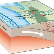
Are the tectonic plates floating on magma? Are the tectonic plates floating on magma?
Earth’s tectonic plates rest upon the asthenosphere, the upper layer of Earth’s mantle. Over short timescales, the mantle behaves like a solid. If you could reach down and grab a handful of mantle rock it would be just that; solid rock. However, over long geologic timescales the mantle can behave like a thick liquid that slowly flows at about the same rate that fingernails grow. Magma does exist...

How fast do tectonic plates move? How fast do tectonic plates move?
Tectonic plates move roughly at the same rate that your fingernails grow. However, individual tectonic plates move at different speeds and in different directions. We can measure crustal motion using satellite-based Global Positioning Systems (GPS) that measure within a fraction of a millimeter per year. We can also estimate velocities over the span of geologic time using rocks in ocean floors...

I think I found a meteorite. How can I tell for sure? I think I found a meteorite. How can I tell for sure?
Meteorites are fragments of rock or metal that fall to Earth from space. They are very rare, but many people find unusual rocks or pieces of metal and wonder if they might have found a meteorite. The USGS doesn't verify meteorites, but they have several properties that help distinguish them from other rocks: Density: Meteorites are usually quite heavy for their size, since they contain metallic...

I have (or think I have) a sinkhole on my property. What should I do? I have (or think I have) a sinkhole on my property. What should I do?
While the USGS studies the types of rocks that can potentially form sinkholes, we don’t investigate individual sinkholes on private property. First, rule out human causes for your feature. Some sinkholes are caused by leaky underground pipes (talk to your utility company) and some are old construction pits or other buried materials that have settled. If you’re confident of a natural cause for your...

Can you identify my rock or mineral? Can you identify my rock or mineral?
Rocks and minerals must be examined in person from all perspectives for accurate identification; they are extremely difficult to identify through photographs. You will get the best results by taking your rock or mineral to a local source where it can be handled and examined closely. Possibilities include: Your state geological survey A natural science museum A college or university with a geology...

What is the National Geologic Map Database? What is the National Geologic Map Database?
The National Geologic Map Database (NGMDB) is an archive of geoscience maps (including geology maps), reports, and stratigraphic information for the United States. The NGMDB contains information on more than 90,000 maps and related geoscience reports published from the early 1800s to the present day, by more than 630 agencies, universities, associations, and private companies. Much of the content...

How can I find original field notes made by USGS geologists and geographers? How can I find original field notes made by USGS geologists and geographers?
The USGS Field Records Collection is an archive of unpublished field notes, maps, correspondence, manuscripts, analysis reports, and other data created or collected by USGS Geology Discipline scientists during field studies and other project work. The collection is located in the USGS Library in Denver, Colorado, and is available for on-premises examination during normal library hours. See the...

Where can I obtain soil surveys? Where can I obtain soil surveys?
A soil survey is the systematic description, classification, and mapping of soils in an area. They are published by the USDA Natural Resources Conservation Service (NRCS), formerly known as the Soil Conservation Service. NRCS soil surveys are available from several sources: Some are on the NRCS website. Published soil surveys can be found at some libraries or borrowed through interlibrary loan...

How did Half Dome, the massive rock monument in Yosemite National Park, acquire its unique shape? How did Half Dome, the massive rock monument in Yosemite National Park, acquire its unique shape?
At the head of the valley in Yosemite National Park - as if on a pedestal - stands Half Dome. It is smoothly rounded on three sides and a sheer vertical face on the fourth. Half Dome, which stands nearly 8,800 feet (2,682 meters) above sea level, is composed of granodiorite, and is the remains of a magma chamber that cooled slowly and crystallized thousands of feet beneath the Earth's surface. The...