
Central Valley Regional Overview
Learn details about the four main regions of the Central Valley.
The Central Valley, also known as the Great Valley of California, covers about 20,000 square miles and is one of the more notable structural depressions in the world. Occupying a central position in California, it is bounded by the Cascade Range to the north, the Sierra Nevada to the east, the Tehachapi Mountains to the south, and the Coast Ranges and San Francisco Bay to the west.

The Valley is a vast agricultural region drained by the Sacramento and San Joaquin Rivers. The Valley averages about 50 miles in width and extends about 400 mi northwest from the Tehachapi Mountains to Redding. Generally, most of the valley lies close to sea level and the land surface has very low relief but is higher along the valley margins.
The Central Valley can be divided into two large parts: the northern one-third is known as the Sacramento Valley and the southern two-thirds is known as the San Joaquin Valley. The San Joaquin Valley can be split further into the San Joaquin Basin and the Tulare Basin. The San Joaquin and Sacramento Valleys meet in the Delta area where the combined discharge of the Sacramento and San Joaquin Rivers flows through the Central Valley's one natural outlet, the Carquinez Strait, on its way to San Francisco Bay and the Pacific Ocean. Just east of the Delta, several streams issue from the Sierra Nevada into the valley and flow to the Delta in an area referred to as the Eastside Streams.
Valley Facts
- More than 250 different crops are grown in the Central Valley with an estimated value of \$17 billion per year
- Approximately 75% of the irrigated land in California and 17% of the Nation's irrigated land is in the Central Valley
- Using fewer than 1% of U.S. farmland, the Central Valley supplies 8% of U.S. agricultural output (by value) and produces 1/4 of the Nation's food, including 40% of the Nation's fruits, nuts, and other table foods.
- The predominate crop types are cereal grains, hay, cotton, tomatoes, vegetables, citrus, tree fruits, nuts, table grapes, and wine grapes.
- About 20% of the Nation's groundwater demand is supplied from pumping Central Valley aquifers, making it the second-most-pumped aquifer system in the U.S.
- The Central Valley is one of the more notable structural depressions in the world.
Within the Central Valley are four main regions:
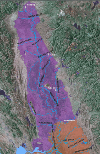
Sacramento Valley
Population
The 1995 population of the Sacramento Valley was 2.4 million (California Department of Water Resources, 2003).
Major Cities
Sacramento, Redding
Geographic Features
Sutter Buttes, a volcanic remnant in the south-central part of the Sacramento Valley, and the Sacramento, Feather, Yuba, Bear, and American Rivers
Climate
The Sacramento Valley has mild winters and hot, dry summers.
Land Use
The natural levees that border the Sacramento-Feather River system create backwater basins of heavy clay soils that sustain rice farms and duck clubs. Truck, field, orchard, and rice crops are grown on approximately 2.1 million acres; rice represents about 23% of the total acreage (California Department of Water Resources, 2003).
Water Use
Depending on location, agriculture in the Sacramento Valley relies on a variable combination of surface water and groundwater. Groundwater accounts for less than 30% of the annual supply used for agricultural and urban purposes in this area. The Sacramento Valley, generally rich in surface water, provides water for much of California's urban and agricultural needs (California Department of Water Resources, 2003).
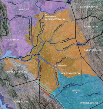
Delta and Eastside Streams
Size
The Delta estuary covers about 1,000 square miles, has 1,100 miles of rivers and 1,600 miles of levees.
Major Cities
Sacramento, Stockton
Geographic Features
Sacramento, San Joaquin, Cosumnes, Mokelumne, and Calaveras Rivers
The "Delta" is an estuary and is actually the reverse of a classic delta, because multiple rivers come together rather than one river expanding in width outside of it's channel.
Land Use
The landuse in the Delta is predominantly agriculture. The Delta includes about 55 islands or tracts that are imperfectly protected from flooding by over 1,000 miles of levees. Many of the islands in the central Delta are 10 to nearly 25 feet below sea level because of land subsidence associated with drainage for agriculture. There are also numerous smaller, unleveed islands that remain near sea level (Galloway and others, 1999).
Water Use
The Delta is a major source of fresh water for domestic, industrial, and agricultural uses as well as an important habitat to 750 animal and plant species. It also supports species listed as threatened or endangered: Delta smelt, Chinook salmon, and Steelhead.
About 83 percent of water exported from the Delta is used for agriculture. The remainder is used for urban and environmental purposes in Central and Southern California (California Department of Water Resources, 1998).
Levees
In the late 1800s, large-scale agricultural development in the Delta required levee building to prevent historically frequent flooding on the low-lying Delta islands. The levees now protect farmlands that have sunk (or subsided) as much as 22 ft below sea level. An extensive network of drainage ditches prevents these subsided islands from internal flooding. Accumulated drainage is pumped through or over the levees into stream channels.
San Joaquin Basin

Population
The total population of the San Joaquin Basin in 2000 was approximately 2 million (Great Valley Center, 2005).
Major Cities
Stockton, Turlock, Merced, and Modesto
Geographic Features
San Joaquin, Stanislaus, Tuolumne, and Merced Rivers, and the southern part of the Delta
Climate
The San Joaquin Basin has mild winters and particularly hot and dry summers.
Land Use
A large part of the population of the basin is involved in all facets of agricultural production. Gradually, the population is shifting towards supporting the large urban areas and industry.
In 2000, approximately 2/3 of the area was used for agriculture. The southwestern half of the San Joaquin Basin has long been known for its cotton fields, but recent drops in cotton prices have caused a rapid shift to other crops, particularly almond orchards. On the eastern side of the San Joaquin Basin, alluvial fans are dominated by deciduous fruit and nut orchards. The remainder of the irrigated area is covered by pasture, truck, and field crops.
Water Use
Although surface water is used when it is available, the region relies heavily on groundwater. Groundwater accounts for about 30% of the annual supply of both types of water used for agricultural and urban purposes (California Department of Water Resources, 2003; Chapter C).Only about 8% of the historic San Joaquin Valley wetland acreage remains today (Moore and others, 1990).
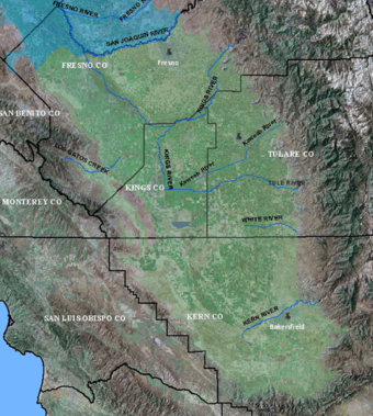
Tulare Basin
Population
The total population of the Tulare Basin in 2000 was approximately 4 million (Great Valley Center, 2005).
Major Cities
Fresno, Bakersfield, Visalia
Geographic Features
Tulare Lake Basin, Kettleman Hills, Kings River, Kaweah River, Kern River, Tule River, Tulare Lake, Kern Lake, Buena Vista Lake
Climate
The Tulare Basin has mild winters and hot dry summers. Despite transient tule marsh areas, the area is dry and the valley summer heat is intense.
Land Use
About 4% of the basin area is urban. The present-day Tulare Basin has been developed extensively for agriculture and petroleum extraction. Agricultural fields, vineyards, and orange groves are interspersed with oil fields (Parsons, 1987). Grains, cotton, and corn are the main agricultural crops in the Tulare Basin.
Water Use
Until recently, Fresno and Visalia were entirely dependent on groundwater for their supply, now these cities are slowly adding surface water to their supplies. Water used for agriculture in the Tulare Basin constituted 69% of the total water use in 1998 and 86% of the total in 2001 (Great Valley Center, 2005).
Surface water is preferred over groundwater because of relative costs. Uncertainty and limitations of surface-water deliveries from the Delta are of growing concern. Groundwater often is used to replace much of the shortfall in surface-water supplies. Because groundwater is a finite resource, alternate sources of water either are being considered or starting to be used.