
Water Availability
Water Availability
Filter Total Items: 35
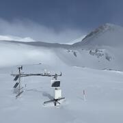
Next Generation Water Observing System (NGWOS) Snow Hydrology Monitoring Network in the Upper Colorado River Basin
Representative observations of snowpack conditions are vital for informing water availability assessments and modeling in snow dominated regions of the western United States. The U.S. Geological Survey (USGS) established a snow hydrology monitoring network in 2021 with the objective of providing high-quality, representative, and publicly available data on snowpack, soil moisture, and...

Agricultural Return Flows in the Upper Gunnison River Basin
Canals and ditches divert water from streams in the Upper Gunnison River Basin, Colorado, to irrigate agricultural fields. In some areas, irrigation water that percolates below the root zone can locally recharge groundwater and later return to streams through the subsurface, which can extend streamflow outside of the snowmelt runoff season. Understanding the timing and quantity of agricultural...

Camera Installations Collecting Hydrologic Imagery at USGS Monitoring Locations in Colorado
The Colorado Water Science Center Network Integration and Science Innovation team has focused on installing cameras at U.S. Geological Survey (USGS) monitoring locations for situational and observational awareness of conditions at streams, rivers, and lakes in Colorado. Several USGS monitoring locations have been configured with cellular modems and network cameras to obtain still and video imagery...

Colorado River Headwaters, Water Isotope Network
Water availability is controlled by processes that can be hard to measure, like the process of groundwater discharging from a streambed that becomes streamflow. Naturally occurring, radioactive and stable (non-radioactive) isotopes can help trace those processes, particularly the isotopes of hydrogen and oxygen that are part of the water molecule. Tritium, the radioactive isotope of hydrogen, has...

Hydrology of and potential for groundwater storage in the alluvial aquifer in the Wet Mountain Valley, Colorado
Hydrologic analysis of the alluvial aquifer in the Wet Mountain Valley has been undertaken using synoptic streamflow and groundwater-level elevation measurements, aquifer tests, water-quality sampling and data analysis, and numerical groundwater-flow modeling. These datasets together provide an encompassing view of the interconnected water resources in the area and allow for quantitative...

Characterization of Streamflow, Suspended Sediment, and Nutrients in the Upper Yampa River Basin
The Upper Yampa River Basin (UYRB) drains approximately 1,800 square miles west of the Continental Divide in northwestern Colorado. In 2019, the USGS, in cooperation with local stakeholders in the UYRB water community, initiated a study to characterize streamflow, suspended sediment, and nutrients using historic and recently acquired water-quality data from a long-term monitoring program initiated...

Peak-streamflow , Mean-streamflow , and Low-streamflow Equations for Western Colorado
Reliable peak-streamflow data are critical to design transportation infrastructure, such as bridges, culverts, dams, and floodplain inundation maps. At gaged sites, where sufficient long-term streamflow data have been collected, statistics can be obtained from available publications, by an analysis of available data in the U.S. Geological Survey (USGS) National Water Information System (NWIS)...

Under-Ice: Computing Real-time Discharge
Under-ice discharge is estimated using open-water reference hydrographs; however, the ratings for ice-affected sites are generally qualified as poor. The U.S. Geological Survey (USGS), in collaboration with the Colorado Water Conservation Board, conducted a proof-of-concept to develop an alternative method for computing under-ice discharge using hydroacoustics and the Probability Concept.

Peak Discharge, Flood Frequency, and Peak Stage of Floods
The U.S. Geological Survey (USGS), in cooperation with the Colorado Department of Transportation, determined the peak discharge, annual exceedance probability (flood frequency), and peak stage of two floods that took place on Big Cottonwood Creek at U.S. Highway 50 near Coaldale, Colorado (hereafter referred to as “Big Cottonwood Creek site”), on August 23, 2016, and on Fountain Creek below U.S...

Water-Budget Analysis of the Upper Big Sandy Alluvial Aquifer
The Upper Big Sandy Groundwater Management District is concerned with potentially declining groundwater levels and thus available groundwater in storage for the Upper Big Sandy alluvial aquifer in eastern Colorado This project evaluated changes in groundwater storage within the Upper Big Sandy Designated Groundwater Basin by updating water-budget results for the alluvial aquifer from the Denver...

Transit-loss accounting program for Monument and Fountain Creeks, El Paso and Pueblo Counties, Colorado
Since the 1980s, a transit-loss accounting program has been used for daily accounting of native and transmountain water by the Colorado Division of Water Resources (CDWR) to determine transit losses and water allocations along Fountain Creek and Monument Creek, Colorado. The Colorado Water Science Center has been involved in developing, modifying, and supporting the program over the course of its...

National Groundwater Monitoring Network 2016-2017
The National Ground-Water Monitoring Network (NGWMN) is a compilation of selected wells monitoring groundwater aquifers all around the nation. The NGWMN Data Portal brings groundwater data together in one place to provide users with current and reliable information for the planning, management, and development of groundwater resources.