
The Aqueous Flow Concentration Estimator (AFCE): Software for Estimation of Ambient Groundwater Flow in Bedrock Open Boreholes
The U.S. Geological Survey (USGS) developed a tool that uses a chemical budget approach to help determine which fractures in a fracture zone may be dominating the water chemistry of open boreholes in bedrock aquifers. The tool uses a Monte Carlo approach and measured concentrations of anthropogenic contaminants to simulate many different scenarios and predict the most likely source direction of the contaminants.
Ambient groundwater flow in open boreholes drilled in fractured crystalline rocks and other low-permeability rocks can be difficult to quantify because low flow rates may fall below detection levels of conventional borehole flow meter tools. Non-detection of ambient flows can provide a false interpretation that groundwater flow between and among fractures or different hydrogeologic units is negligible, which may lead to unexpected cross contamination if open boreholes are left unsealed.
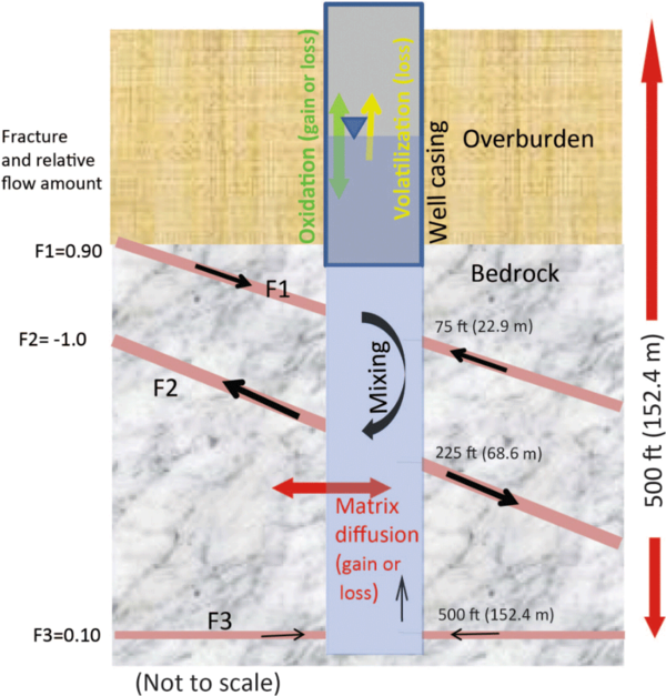
A schematic of an open borehole and processes that can affect water chemistry from the inflowing fracture water
The Aqueous Flow Concentration Estimator (AFCE) tool makes use of combined groundwater data of contaminant concentrations from open boreholes drilled in fractured rock, including: (1) discrete groundwater samples collected from fracture zones via straddle-packer methods that represent the input variable; and (2) passive samples collected from a vertical profile of samplers in the wellbore water that represent the model-calibration match. The concentrations of contaminants in groundwater derived from the passive samplers represent a partially mixed sample of the wellbore water and provide information about the proportion of inflowing groundwater from the discrete fracture networks.
The AFCE program compares, through random iteration, the various potential contaminant input combinations from inflow of groundwater into the open borehole via fracture zones as it relates to the wellbore water contaminant concentration. A high number of successful simulation outcomes (greater than 20) within a user-specified tolerance between the input combinations and the calibration match indicates a higher confidence in model-simulated ambient groundwater-flow patterns.
With the assistance of the U.S. Environmental Protection Agency, this approach was tested with chlorinated volatile organic compounds using data collected at the Savage Municipal Well Superfund site in New Hampshire and the Hidden Lane Superfund site in Sterling, Virginia. Identifying outflow zones helped reduce uncertainty in simulated results. Model outputs and observation data were comparable.
Collaborations with EPA on Contaminated Site Hydrology

Augmented Site Characterization of PFAS Manufacturing and Processing Facilities

Detailed Characterization of the Savage Superfund Site, New Hampshire

The Purge Analyzer Tool (PAT) to Assess Optimal Pumping Parameters in the Collection of Representative Groundwater Samples from Wells
The U.S. Geological Survey (USGS) developed a tool that uses a chemical budget approach to help determine which fractures in a fracture zone may be dominating the water chemistry of open boreholes in bedrock aquifers. The tool uses a Monte Carlo approach and measured concentrations of anthropogenic contaminants to simulate many different scenarios and predict the most likely source direction of the contaminants.
Ambient groundwater flow in open boreholes drilled in fractured crystalline rocks and other low-permeability rocks can be difficult to quantify because low flow rates may fall below detection levels of conventional borehole flow meter tools. Non-detection of ambient flows can provide a false interpretation that groundwater flow between and among fractures or different hydrogeologic units is negligible, which may lead to unexpected cross contamination if open boreholes are left unsealed.
A schematic of an open borehole and processes that can affect water chemistry from the inflowing fracture water
The Aqueous Flow Concentration Estimator (AFCE) tool makes use of combined groundwater data of contaminant concentrations from open boreholes drilled in fractured rock, including: (1) discrete groundwater samples collected from fracture zones via straddle-packer methods that represent the input variable; and (2) passive samples collected from a vertical profile of samplers in the wellbore water that represent the model-calibration match. The concentrations of contaminants in groundwater derived from the passive samplers represent a partially mixed sample of the wellbore water and provide information about the proportion of inflowing groundwater from the discrete fracture networks.
The AFCE program compares, through random iteration, the various potential contaminant input combinations from inflow of groundwater into the open borehole via fracture zones as it relates to the wellbore water contaminant concentration. A high number of successful simulation outcomes (greater than 20) within a user-specified tolerance between the input combinations and the calibration match indicates a higher confidence in model-simulated ambient groundwater-flow patterns.
With the assistance of the U.S. Environmental Protection Agency, this approach was tested with chlorinated volatile organic compounds using data collected at the Savage Municipal Well Superfund site in New Hampshire and the Hidden Lane Superfund site in Sterling, Virginia. Identifying outflow zones helped reduce uncertainty in simulated results. Model outputs and observation data were comparable.
Collaborations with EPA on Contaminated Site Hydrology
Augmented Site Characterization of PFAS Manufacturing and Processing Facilities
Detailed Characterization of the Savage Superfund Site, New Hampshire