
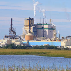
A view of the nort-facing slope of the Coakley Landfill Superfund Site in Northampton, New Hampshire. Pipes used to vent landfill gases can be seen in the distance.
Philip T. Harte, P.G. (Former Employee)
Science and Products
Collaborations with EPA on Contaminated Site Hydrology
The U.S. Geological Survey (USGS), in cooperation with the U.S. Environmental Protection Agency (EPA), is developing tools and methods to help assess the fate and transport of anthropogenic and geologically sourced contaminants in the water cycle at waste sites throughout the nation.

Augmented Site Characterization of PFAS Manufacturing and Processing Facilities
The U.S. Geological Survey (USGS) is supporting the U.S. Environmental Protection Agency (EPA) in assessing facilities nationwide that have historically produced per- and polyfluoroalkyl substances (PFAS) or used them in chemical manufacturing processes. In collaboration with EPA subcontractors, USGS is providing subject-matter expertise in PFAS fate and transport in the vadose zone and...

Communication of Complex Contaminant Transport Processes in Groundwater
The U.S. Geological Survey (USGS) has partnered with U.S. Environmental Protection Agency (EPA) to develop education products that can help users build conceptual models and make decisions about appropriate remedial strategies. Education products include training seminars, multimedia, and factsheets that review and discuss key issues in contaminant transport. These materials can provide helpful...

Detailed Characterization of the Savage Superfund Site, New Hampshire
The U.S. Geological Survey (USGS), in cooperation with the U.S. Environmental Protection Agency and the New Hampshire Department of Environmental Services, is conducting advanced site characterization activities at the Savage Municipal Water Supply Superfund site in Milford, New Hampshire, and implementing new remediation efforts based on USGS science and tools.

The Aqueous Flow Concentration Estimator (AFCE): Software for Estimation of Ambient Groundwater Flow in Bedrock Open Boreholes
The U.S. Geological Survey (USGS) developed a tool that uses a chemical budget approach to help determine which fractures in a fracture zone may be dominating the water chemistry of open boreholes in bedrock aquifers. The tool uses a Monte Carlo approach and measured concentrations of anthropogenic contaminants to simulate many different scenarios and predict the most likely source direction of...

Geochemical Fingerprinting of Anthropogenic and Geologically Sourced Uranium at the Homestake Superfund Site, New Mexico
The U.S. Geological Survey (USGS), in cooperation with the U.S. Environmental Protection Agency, the Nuclear Regulatory Commission, and the New Mexico Environment Department, utilized a multiparameter geochemical-isotopic fingerprinting approach to differentiate anthropogenic and natural signatures of uranium contamination near the Homestake uranium mill Superfund site near Milan, New Mexico.

The Purge Analyzer Tool (PAT) to Assess Optimal Pumping Parameters in the Collection of Representative Groundwater Samples from Wells
The U.S. Geological Survey (USGS), in cooperation with the U.S. Environmental Protection Agency, has developed an analytical model to assess in-well groundwater flow conditions during the collection of groundwater samples from monitoring wells. The Purge Analyzer Tool (PAT) can be used by professionals conducting groundwater sampling to compute parameters that can inform when and how to collect...
The Coakley Landfill Superfund Site
A view of the nort-facing slope of the Coakley Landfill Superfund Site in Northampton, New Hampshire. Pipes used to vent landfill gases can be seen in the distance.
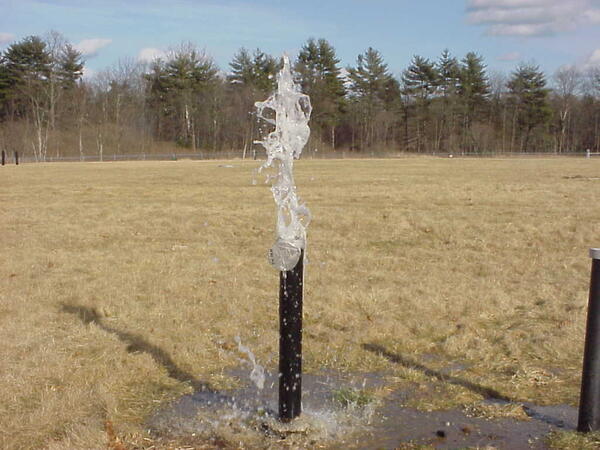
Groundwater Well Ejects Water from Air Sparging at Savage Municipal Water Supply Superfund Site
Groundwater Well Ejects Water from Air Sparging at Savage Municipal Water Supply Superfund SiteA groundwater well at the Savage Municipal Water Supply Superfund Site ejects water as a result of air sparging taking place in an adjacent well. Air sparging is a technique used in soil remediation that sneds pressurized air into the ground to remove soil contaminants.

Low-Flow Sampling of Groundwater at Stringfellow Superfund Site in California
Low-Flow Sampling of Groundwater at Stringfellow Superfund Site in CaliforniaLow-flow groundwater sampling data was collected at the Stringfellow Superfund Site in California. This data was used to assess how well the Purge Analyzer Tool simulates in-well groundwater flow.

Measuring Water-Levels in a Monitoring Well at Homestake Mining Company Superfund Site
Measuring Water-Levels in a Monitoring Well at Homestake Mining Company Superfund SiteResearch Hydrologist Phil Harte takes water-level measurements from a monitoring well that is adjacent to a uranium waste pile (visible in the background of the photograph).

Different Types of Iron Staining on Downhole Samplers
Different Types of Iron Staining on Downhole SamplersUSGS Research Hydrologist Philip Harte describes the different types of different iron staining visible on downhole samplers that were used in passive sampling of groundwater wells.
Different Types of Iron Staining on Downhole Samplers
Different Types of Iron Staining on Downhole SamplersUSGS Research Hydrologist Philip Harte describes the different types of different iron staining visible on downhole samplers that were used in passive sampling of groundwater wells.
Science and Products
Collaborations with EPA on Contaminated Site Hydrology
The U.S. Geological Survey (USGS), in cooperation with the U.S. Environmental Protection Agency (EPA), is developing tools and methods to help assess the fate and transport of anthropogenic and geologically sourced contaminants in the water cycle at waste sites throughout the nation.
Augmented Site Characterization of PFAS Manufacturing and Processing Facilities
The U.S. Geological Survey (USGS) is supporting the U.S. Environmental Protection Agency (EPA) in assessing facilities nationwide that have historically produced per- and polyfluoroalkyl substances (PFAS) or used them in chemical manufacturing processes. In collaboration with EPA subcontractors, USGS is providing subject-matter expertise in PFAS fate and transport in the vadose zone and...
Communication of Complex Contaminant Transport Processes in Groundwater
The U.S. Geological Survey (USGS) has partnered with U.S. Environmental Protection Agency (EPA) to develop education products that can help users build conceptual models and make decisions about appropriate remedial strategies. Education products include training seminars, multimedia, and factsheets that review and discuss key issues in contaminant transport. These materials can provide helpful...
Detailed Characterization of the Savage Superfund Site, New Hampshire
The U.S. Geological Survey (USGS), in cooperation with the U.S. Environmental Protection Agency and the New Hampshire Department of Environmental Services, is conducting advanced site characterization activities at the Savage Municipal Water Supply Superfund site in Milford, New Hampshire, and implementing new remediation efforts based on USGS science and tools.
The Aqueous Flow Concentration Estimator (AFCE): Software for Estimation of Ambient Groundwater Flow in Bedrock Open Boreholes
The U.S. Geological Survey (USGS) developed a tool that uses a chemical budget approach to help determine which fractures in a fracture zone may be dominating the water chemistry of open boreholes in bedrock aquifers. The tool uses a Monte Carlo approach and measured concentrations of anthropogenic contaminants to simulate many different scenarios and predict the most likely source direction of...
Geochemical Fingerprinting of Anthropogenic and Geologically Sourced Uranium at the Homestake Superfund Site, New Mexico
The U.S. Geological Survey (USGS), in cooperation with the U.S. Environmental Protection Agency, the Nuclear Regulatory Commission, and the New Mexico Environment Department, utilized a multiparameter geochemical-isotopic fingerprinting approach to differentiate anthropogenic and natural signatures of uranium contamination near the Homestake uranium mill Superfund site near Milan, New Mexico.
The Purge Analyzer Tool (PAT) to Assess Optimal Pumping Parameters in the Collection of Representative Groundwater Samples from Wells
The U.S. Geological Survey (USGS), in cooperation with the U.S. Environmental Protection Agency, has developed an analytical model to assess in-well groundwater flow conditions during the collection of groundwater samples from monitoring wells. The Purge Analyzer Tool (PAT) can be used by professionals conducting groundwater sampling to compute parameters that can inform when and how to collect...
The Coakley Landfill Superfund Site
A view of the nort-facing slope of the Coakley Landfill Superfund Site in Northampton, New Hampshire. Pipes used to vent landfill gases can be seen in the distance.
A view of the nort-facing slope of the Coakley Landfill Superfund Site in Northampton, New Hampshire. Pipes used to vent landfill gases can be seen in the distance.
Groundwater Well Ejects Water from Air Sparging at Savage Municipal Water Supply Superfund Site
Groundwater Well Ejects Water from Air Sparging at Savage Municipal Water Supply Superfund SiteA groundwater well at the Savage Municipal Water Supply Superfund Site ejects water as a result of air sparging taking place in an adjacent well. Air sparging is a technique used in soil remediation that sneds pressurized air into the ground to remove soil contaminants.
Low-Flow Sampling of Groundwater at Stringfellow Superfund Site in California
Low-Flow Sampling of Groundwater at Stringfellow Superfund Site in CaliforniaLow-flow groundwater sampling data was collected at the Stringfellow Superfund Site in California. This data was used to assess how well the Purge Analyzer Tool simulates in-well groundwater flow.
Measuring Water-Levels in a Monitoring Well at Homestake Mining Company Superfund Site
Measuring Water-Levels in a Monitoring Well at Homestake Mining Company Superfund SiteResearch Hydrologist Phil Harte takes water-level measurements from a monitoring well that is adjacent to a uranium waste pile (visible in the background of the photograph).
Different Types of Iron Staining on Downhole Samplers
Different Types of Iron Staining on Downhole SamplersUSGS Research Hydrologist Philip Harte describes the different types of different iron staining visible on downhole samplers that were used in passive sampling of groundwater wells.
Different Types of Iron Staining on Downhole Samplers
Different Types of Iron Staining on Downhole SamplersUSGS Research Hydrologist Philip Harte describes the different types of different iron staining visible on downhole samplers that were used in passive sampling of groundwater wells.