
Detailed Characterization of the Savage Superfund Site, New Hampshire
The U.S. Geological Survey (USGS), in cooperation with the U.S. Environmental Protection Agency and the New Hampshire Department of Environmental Services, is conducting advanced site characterization activities at the Savage Municipal Water Supply Superfund site in Milford, New Hampshire, and implementing new remediation efforts based on USGS science and tools.
The program includes studying contaminant occurrence, long-term water quality monitoring, and groundwater flow and transport modeling to assess remediation strategies. USGS staff have also mapped site geologic and hydrogeologic units. This 20-year collaboration is facilitating the implementation and evaluation of new and updated remediation strategies.
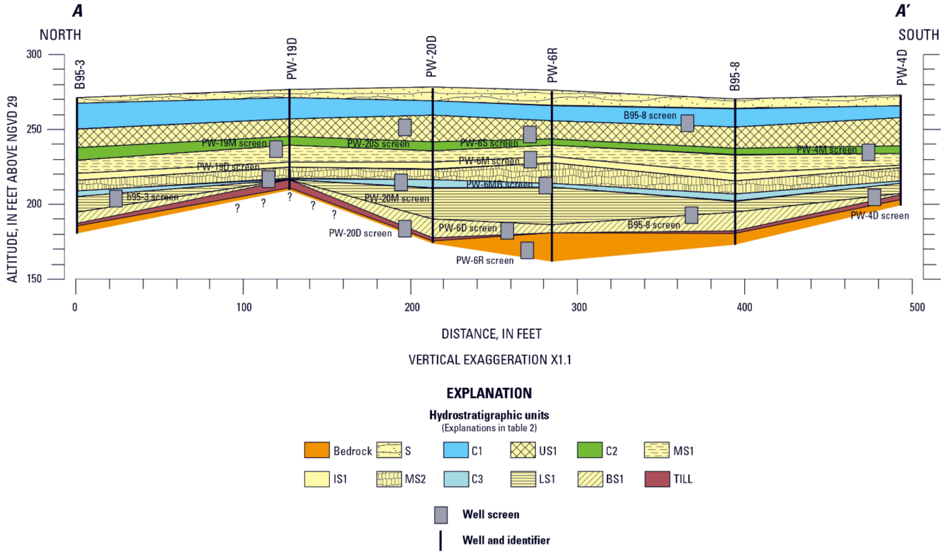
Transverse cross section showing hydrostratigraphic units at the Savage Municipal Well Superfund site.
The Savage Municipal Water Supply Superfund site includes a plume of contaminated groundwater that connects with several water bodies. From the 1940s to the 1980s, four major industrial facilities were located hydraulically upgradient of the Savage Municipal Well, which provided potable water to the town’s approximately 10,000 residents. In 1983, the well was sampled for volatile organic compounds (VOCs) for the first time as mandated by the Safe Drinking Water Act. VOCs were identified in the well at concentrations exceeding drinking water standards and the well was shut down. Shortly thereafter, in September 1984, the site was added to the National Priorities List. Sixteen constituents of concern (COCs) have been identified, including heavy metals in addition to VOCs.
The hydrogeology of the site is complex: a river and a brook drain the site, and these and an unconfined overburden glacial outwash aquifer are hydraulically connected with a fractured crystalline bedrock aquifer. Flowpaths are complex and the interactions of COCs with underground rock and water (subsurface media) are affected by diverse material properties and fracture networks. Since 2001, USGS contributions to work at this site include:
- Implementing and conducting long-term monitoring of water quality parameters and COCs;
- Mapping hydrostratigraphic units and fracture networks;
- Simulating solute transport for multiple COCs in overburden and bedrock aquifers;
- Simulating the effectiveness of proposed remedies prior to implementation; and
- Monitoring the effectiveness of remedies after installation.

Groundwater well ejects water from air sparging at Savage Municipal Water Supply Superfund Site.
The U.S. Geological Survey (USGS), in cooperation with the U.S. Environmental Protection Agency and the New Hampshire Department of Environmental Services, is conducting advanced site characterization activities at the Savage Municipal Water Supply Superfund site in Milford, New Hampshire, and implementing new remediation efforts based on USGS science and tools.
The program includes studying contaminant occurrence, long-term water quality monitoring, and groundwater flow and transport modeling to assess remediation strategies. USGS staff have also mapped site geologic and hydrogeologic units. This 20-year collaboration is facilitating the implementation and evaluation of new and updated remediation strategies.
Transverse cross section showing hydrostratigraphic units at the Savage Municipal Well Superfund site.
The Savage Municipal Water Supply Superfund site includes a plume of contaminated groundwater that connects with several water bodies. From the 1940s to the 1980s, four major industrial facilities were located hydraulically upgradient of the Savage Municipal Well, which provided potable water to the town’s approximately 10,000 residents. In 1983, the well was sampled for volatile organic compounds (VOCs) for the first time as mandated by the Safe Drinking Water Act. VOCs were identified in the well at concentrations exceeding drinking water standards and the well was shut down. Shortly thereafter, in September 1984, the site was added to the National Priorities List. Sixteen constituents of concern (COCs) have been identified, including heavy metals in addition to VOCs.
The hydrogeology of the site is complex: a river and a brook drain the site, and these and an unconfined overburden glacial outwash aquifer are hydraulically connected with a fractured crystalline bedrock aquifer. Flowpaths are complex and the interactions of COCs with underground rock and water (subsurface media) are affected by diverse material properties and fracture networks. Since 2001, USGS contributions to work at this site include:
- Implementing and conducting long-term monitoring of water quality parameters and COCs;
- Mapping hydrostratigraphic units and fracture networks;
- Simulating solute transport for multiple COCs in overburden and bedrock aquifers;
- Simulating the effectiveness of proposed remedies prior to implementation; and
- Monitoring the effectiveness of remedies after installation.
Groundwater well ejects water from air sparging at Savage Municipal Water Supply Superfund Site.