
Airborne Electromagnetic (AEM) Surveys for Southwest Michigan, 2026-2027
In partnership with the Michigan Department of Environment, Great Lakes, and Energy (EGLE), the U.S. Geological Survey (USGS) is conducting an Airborne Electromagnetic (AEM) Survey project in Southwestern Michigan during 2026 and 2027.

What is the survey for?
The survey will use airborne electromagnetic (AEM) technology to better understand the structure of aquifers and through that understanding better understand groundwater resources. To accomplish this, AEM data will be collected to image surficial confining units, shallow aquifers, and bedrock units. The use of a helicopter-towed AEM sensor (looks like a large hoop hanging from a cable) for this type of evaluation uses cutting-edge technology and provides accurate science-based data about below-ground properties that are otherwise difficult to assess over large areas. This project is being carried out in response to the recommendations of the Michigan Water Use Advisory Council, which determined that additional data are needed to characterize water resources across the state.
When and where will it happen?
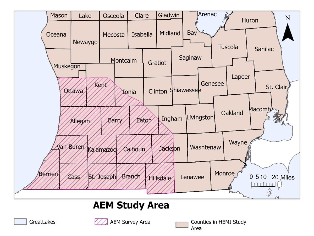
Flights are expected to begin in spring and conclude in fall of 2026, with exact dates dependent upon weather. The survey will encompass the following counties: Ottawa, Kent, Ionia, Allegan, Barry, Eaton, Ingham, Van Buren, Kalamazoo, Calhoun, Jackson, Berrien, Cass, St. Joseph, Branch, and Hillsdale.
Why is measuring subsurface geology important for water resources?
Michiganders rely upon rivers, streams, lakes, and groundwater for everything from drinking water to irrigation to recreation. Much of Michigan’s drinking water comes from groundwater sources. Using AEM allows scientists to develop a 3D image of the subsurface geology to better predict how water moves through those layers and how groundwater and surface water are connected.

How does this benefit the public?
This survey supports efforts to develop groundwater resources while helping to protect groundwater and promote water quality and availability. The results of the survey will:
- Create a better understanding of aquifer properties
- Address groundwater supply questions
- Improve understanding of the influence of surface activities (agriculture, mining, development, etc.) on groundwater
This project uses the strength of local, state, and federal resources to help many citizens in southwest Michigan.
What type of data will be produced?
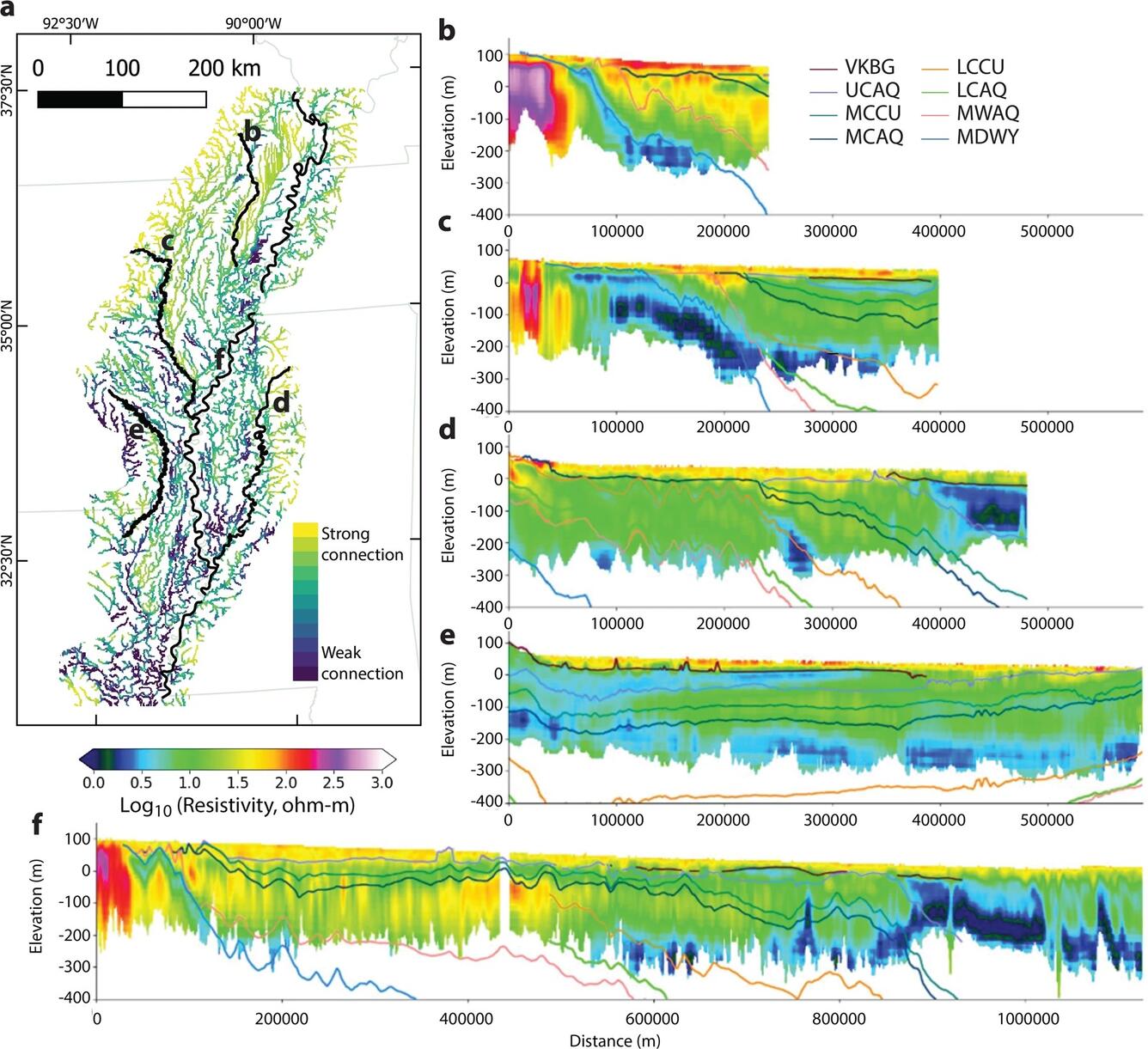
The survey will measure the electromagnetic properties of the ground, which are related to the type of sediments and rock forming aquifers and confining layers at depth. These data will be combined with information from groundwater wells where the materials encountered during the drilling of the well provides information about the subsurface at that location. The AEM surveys provide a great density of data over a wide area to produce relatively high-resolution maps of geology, both at the surface and at depth. In this example from the USGS Mississippi Alluvial Plain project, AEM data were collected along parallel flight lines and following several rivers. Where AEM flights followed or intersected rivers, the resulting resistivity profiles were used to estimate aquifer materials properties at depth beneath the riverbed. Maps and cross sections of electrical resistivity are a standard product from AEM survey work. A more unique product of this AEM survey effort can be seen in part “a” of the figure, which shows a map of the extent of connection between groundwater and surface water along the surveyed streams based on the resistivity of the streambed materials. High-resolution AEM characterization of the 3D geometry of aquifer materials can also be used in the construction of groundwater models, which can help answer questions regarding the potential impact of groundwater pumping upon rivers, lakes, and streams.

Helicopter Activity: What to Expect
- Flights over Michigan are expected to take approximately 4 months depending on weather and flight conditions
- The helicopter is flying a grid pre-determined flight track based on study locations, so it will be seen several times in the same area
- The helicopter will fly relatively low, hundreds of feet above ground
- The helicopter will not fly within 500 ft of buildings according to Federal Aviation Administration (FAA) rules, and will make efforts to fly around people or large equipment on the ground
- The electromagnetic device will not harm plants, animals, or humans
- The low flying helicopter may startle wildlife and cattle, and the helicopter will make efforts to fly around confined animal areas
- Local enforcement and conservation contacts are informed of the activity
- The flight tracker will map the daily progress of the study
- Only depth to bedrock and hydrogeologic properties will be identified through this process
Flights will be carried out in the area of southwestern Michigan shown below.
Additional Information
Contacts
| Topic | Agency | Contact | Phone | |
|---|---|---|---|---|
| Southwest Michigan Flight | USGS | Howard Reeves | hwreeves@usgs.gov | 517-648-5943 |
| AEM Survey and Flight Paths | USGS | Burke Minsley | bminsley@usgs.gov | 303-236-5718 |
| Southwest Michigan Flight | EGLE | Sydey Ruhala | ruhalas@michigan.gov | 517-648-7791 |
In partnership with the Michigan Department of Environment, Great Lakes, and Energy (EGLE), the U.S. Geological Survey (USGS) is conducting an Airborne Electromagnetic (AEM) Survey project in Southwestern Michigan during 2026 and 2027.
What is the survey for?
The survey will use airborne electromagnetic (AEM) technology to better understand the structure of aquifers and through that understanding better understand groundwater resources. To accomplish this, AEM data will be collected to image surficial confining units, shallow aquifers, and bedrock units. The use of a helicopter-towed AEM sensor (looks like a large hoop hanging from a cable) for this type of evaluation uses cutting-edge technology and provides accurate science-based data about below-ground properties that are otherwise difficult to assess over large areas. This project is being carried out in response to the recommendations of the Michigan Water Use Advisory Council, which determined that additional data are needed to characterize water resources across the state.
When and where will it happen?
Flights are expected to begin in spring and conclude in fall of 2026, with exact dates dependent upon weather. The survey will encompass the following counties: Ottawa, Kent, Ionia, Allegan, Barry, Eaton, Ingham, Van Buren, Kalamazoo, Calhoun, Jackson, Berrien, Cass, St. Joseph, Branch, and Hillsdale.
Why is measuring subsurface geology important for water resources?
Michiganders rely upon rivers, streams, lakes, and groundwater for everything from drinking water to irrigation to recreation. Much of Michigan’s drinking water comes from groundwater sources. Using AEM allows scientists to develop a 3D image of the subsurface geology to better predict how water moves through those layers and how groundwater and surface water are connected.
How does this benefit the public?
This survey supports efforts to develop groundwater resources while helping to protect groundwater and promote water quality and availability. The results of the survey will:
- Create a better understanding of aquifer properties
- Address groundwater supply questions
- Improve understanding of the influence of surface activities (agriculture, mining, development, etc.) on groundwater
This project uses the strength of local, state, and federal resources to help many citizens in southwest Michigan.
What type of data will be produced?
The survey will measure the electromagnetic properties of the ground, which are related to the type of sediments and rock forming aquifers and confining layers at depth. These data will be combined with information from groundwater wells where the materials encountered during the drilling of the well provides information about the subsurface at that location. The AEM surveys provide a great density of data over a wide area to produce relatively high-resolution maps of geology, both at the surface and at depth. In this example from the USGS Mississippi Alluvial Plain project, AEM data were collected along parallel flight lines and following several rivers. Where AEM flights followed or intersected rivers, the resulting resistivity profiles were used to estimate aquifer materials properties at depth beneath the riverbed. Maps and cross sections of electrical resistivity are a standard product from AEM survey work. A more unique product of this AEM survey effort can be seen in part “a” of the figure, which shows a map of the extent of connection between groundwater and surface water along the surveyed streams based on the resistivity of the streambed materials. High-resolution AEM characterization of the 3D geometry of aquifer materials can also be used in the construction of groundwater models, which can help answer questions regarding the potential impact of groundwater pumping upon rivers, lakes, and streams.
Helicopter Activity: What to Expect
- Flights over Michigan are expected to take approximately 4 months depending on weather and flight conditions
- The helicopter is flying a grid pre-determined flight track based on study locations, so it will be seen several times in the same area
- The helicopter will fly relatively low, hundreds of feet above ground
- The helicopter will not fly within 500 ft of buildings according to Federal Aviation Administration (FAA) rules, and will make efforts to fly around people or large equipment on the ground
- The electromagnetic device will not harm plants, animals, or humans
- The low flying helicopter may startle wildlife and cattle, and the helicopter will make efforts to fly around confined animal areas
- Local enforcement and conservation contacts are informed of the activity
- The flight tracker will map the daily progress of the study
- Only depth to bedrock and hydrogeologic properties will be identified through this process
Flights will be carried out in the area of southwestern Michigan shown below.
Additional Information
Contacts
| Topic | Agency | Contact | Phone | |
|---|---|---|---|---|
| Southwest Michigan Flight | USGS | Howard Reeves | hwreeves@usgs.gov | 517-648-5943 |
| AEM Survey and Flight Paths | USGS | Burke Minsley | bminsley@usgs.gov | 303-236-5718 |
| Southwest Michigan Flight | EGLE | Sydey Ruhala | ruhalas@michigan.gov | 517-648-7791 |