
Howard W Reeves
Howard W. Reeves is the Center Science Officer and a Research Hydrologist with the Upper Midwest Water Science Center.
Science and Products
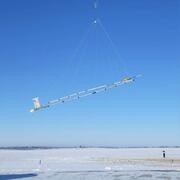
Airborne Electromagnetic (AEM) Surveys for Southwest Michigan, 2026-2027
In partnership with the Michigan Department of Environment, Great Lakes, and Energy (EGLE), the U.S. Geological Survey (USGS) is conducting an Airborne Electromagnetic (AEM) Survey project in Southwestern Michigan during 2026 and 2027.
Hydrologic Enhancement for Michigan (HEMI)
USGS partners with Michigan’s Department of Environment, Great Lakes, and Energy (EGLE) to enhance Michigan’s data on water resources Hydrologic Enhancement for Michigan (HEMI)

Groundwater and Stream Temperature Modeling to Assess the Effect of Warming Temperatures on Coldwater Fish
Cold-water fish species such as trout and salmon are highly valued components of many stream ecosystems in Michigan and the Great Lakes region and are sensitive to rising stream temperatures. For example, the timing of spawning and development rates of these species are affected by stream temperature from late fall through spring. Historically, stream temperature modeling has focused on...

Improving representation of groundwater in foundational Great Lakes hydrologic and hydrodynamic models and data sets
Groundwater plays a critical role in the water balance, however the groundwater component of the hydrologic cycle is frequently overlooked at basin scales because it is difficult to observe and quantify. We address this problem through a novel framework that combines existing hydrological models and data sets with groundwater flux estimates across Earth's largest system of lakes; the...
Science and Products
Airborne Electromagnetic (AEM) Surveys for Southwest Michigan, 2026-2027
In partnership with the Michigan Department of Environment, Great Lakes, and Energy (EGLE), the U.S. Geological Survey (USGS) is conducting an Airborne Electromagnetic (AEM) Survey project in Southwestern Michigan during 2026 and 2027.
Hydrologic Enhancement for Michigan (HEMI)
USGS partners with Michigan’s Department of Environment, Great Lakes, and Energy (EGLE) to enhance Michigan’s data on water resources Hydrologic Enhancement for Michigan (HEMI)
Groundwater and Stream Temperature Modeling to Assess the Effect of Warming Temperatures on Coldwater Fish
Cold-water fish species such as trout and salmon are highly valued components of many stream ecosystems in Michigan and the Great Lakes region and are sensitive to rising stream temperatures. For example, the timing of spawning and development rates of these species are affected by stream temperature from late fall through spring. Historically, stream temperature modeling has focused on...
Improving representation of groundwater in foundational Great Lakes hydrologic and hydrodynamic models and data sets
Groundwater plays a critical role in the water balance, however the groundwater component of the hydrologic cycle is frequently overlooked at basin scales because it is difficult to observe and quantify. We address this problem through a novel framework that combines existing hydrological models and data sets with groundwater flux estimates across Earth's largest system of lakes; the...