
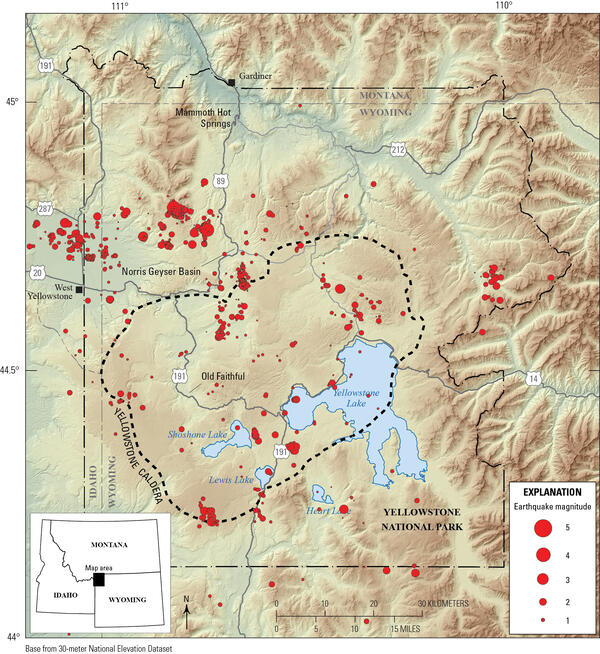
Map of seismicity (red circles) in the Yellowstone region during 2025. Gray lines are roads, black dashed line shows the caldera boundary, Yellowstone National Park is outlined by black dot-dashed line, and gray dashed lines denote state boundaries.
Images
Images related to Yellowstone Volcano Observatory.
Filter Total Items: 706
Map of Yellowstone seismicity in 2025
Map of seismicity (red circles) in the Yellowstone region during 2025. Gray lines are roads, black dashed line shows the caldera boundary, Yellowstone National Park is outlined by black dot-dashed line, and gray dashed lines denote state boundaries.

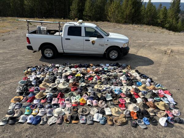
Infographic with statistics about hats that were recovered from thermal areas in Yellowstone National Park during 2025
Infographic with statistics about hats that were recovered from thermal areas in Yellowstone National Park during 2025Infographic showing the numbers, styles, colors, and other data regarding hats recovered from thermal areas by the Yellowstone National Park Geology Program in 2025. Designed by Margery Price, Yellowstone National Park.

Relocated Yellowstone seismicity recorded during 2008-2022
Relocated Yellowstone seismicity recorded during 2008-2022Map view of relocated Yellowstone seismicity recorded during 2008-2022, colored by time, on the left. White line gives the outline of Yellowstone caldera. The A-A’ cross section through Yellowstone Lake is shown at the right and illustrates how seismic swarms that are distinct in time relate to one another. Adapted from Florez and others, 2025 (
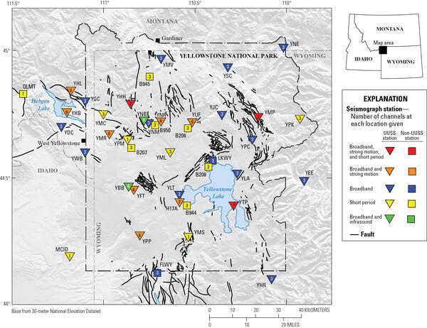
Yellowstone seismic network
Map of seismic stations in the Yellowstone region, with numbers of channels indicated by number and sensor type by color. Inverted triangles indicate stations operated by University of Utah Seismograph Stations (UUSS), and squares indicate stations operated by other agencies.
Map of seismic stations in the Yellowstone region, with numbers of channels indicated by number and sensor type by color. Inverted triangles indicate stations operated by University of Utah Seismograph Stations (UUSS), and squares indicate stations operated by other agencies.
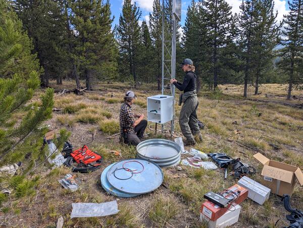
Upgrading the WLWY continuous GPS site in Yellowstone National Park
Upgrading the WLWY continuous GPS site in Yellowstone National ParkEarthScope engineers Brendan Hodge (left) and Lia Lajoie (right) perform upgrades at the WLWY (White Lake) continuous GPS station in Yellowstone National Park. The white box contains the receiver, while the barrel on the ground contains batteries. The tower holds the solar panels, as well as a cellular modem and meteorological sensors that were recently
Hats collected by the Yellowstone National Park Geology Program from sensitive thermal areas in 2025
Hats collected by the Yellowstone National Park Geology Program from sensitive thermal areas in 2025Just some of the hats collected by the Yellowstone National Park Geology Program from sensitive thermal areas throughout the park in 2025. National Park Service photo by Margery Price, September 3, 2025.
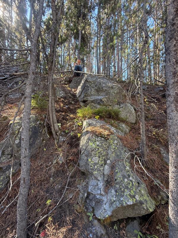
USGS geologist collects a sample from a potential newly recognized lava flow along the Gibbon River, Yellowstone National Park
USGS geologist collects a sample from a potential newly recognized lava flow along the Gibbon River, Yellowstone National ParkUSGS geologist Mark Stelten collects a sample of what is potentially a newly recognized lava flow exposed along the Gibbon River. USGS photo by Nicole Thomas, September 2025.
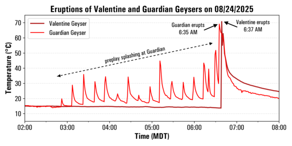
Temperature record from Valentine and Guardian Geysers, Norris Geyser Basin, Yellowstone National Park, from August 24, 2025
Temperature record from Valentine and Guardian Geysers, Norris Geyser Basin, Yellowstone National Park, from August 24, 2025Plot of temperatures measured by continuous loggers at Guardian Geyser (light red) and Valentine Geyser (dark red) on August 24, 2025. Activity at Guardian Geyser included episodic splashing for a few hours prior to the near-simultaneous eruptions of both geysers just after 6:30 a.m. MDT on this date. Data collected by Mara Reed, Yellowstone National Park.
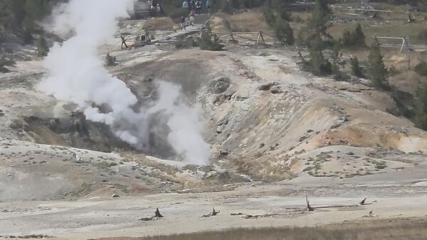
Valentine and Guardian Geysers, Norris Geyser Basin, Yellowstone National Park
Valentine and Guardian Geysers, Norris Geyser Basin, Yellowstone National ParkPhoto of Valentine Geyser and Guardian Geyser in eruption on August 7, 2025. Valentine Geyser is in the rear of the alcove, and Guardian Geyser is at the alcove’s mouth, closer to the camera. Visitors on a trail below the Norris Geyser Basin Museum can be seen at the top of the image. Photo by Carol Beverly, used with permission.
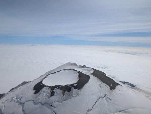
Aerial view of the summit of Mount Rainier taken during the gas flight.
Aerial view of the summit of Mount Rainier taken during the gas flight.Aerial view of the summit of Mount Rainier taken during the gas flight. The photo was taken looking south, and Rainier (14,411’) rises prominently above the cloud deck at about 8,000’. Mount St. Helens (8,357’) is faintly visible in the distance.
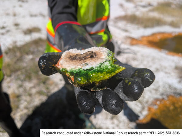
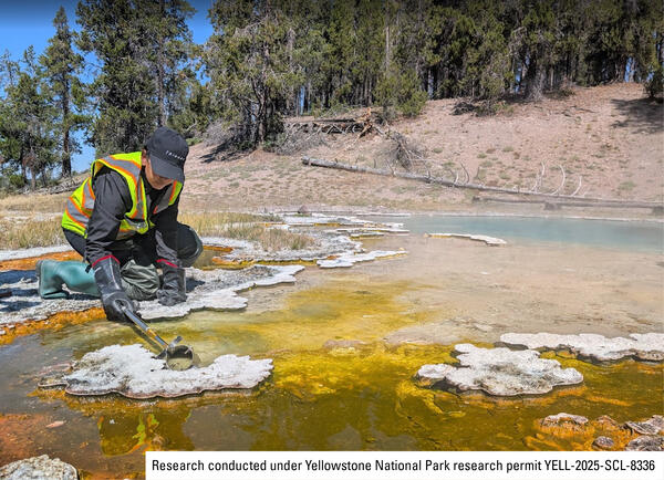
Sample of thermophilic cyanobacteria collected from a hot spring in Yellowstone’s Lower Geyser Basin
Sample of thermophilic cyanobacteria collected from a hot spring in Yellowstone’s Lower Geyser BasinA researcher holds a vibrant green sample of thermophilic cyanobacteria collected from a hot spring in Yellowstone’s Lower Geyser Basin. National Park Service photo by Samantha Hilburn, August 2025.
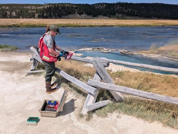
Extracting wind-blown litter from a thermal feature in Yellowstone National ark
Extracting wind-blown litter from a thermal feature in Yellowstone National arkYellowstone National Park Geology Program team member Mara Reed uses a long grabber pole to remove a park map, presumably blown from a visitor's hand or pack by the wind, from a feature in Upper Mammoth Terraces. National Park Service photo by Samantha Hilburn, August 2025.
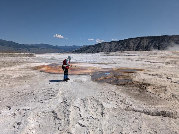
Yellowstone National Park geology team installs safety signage near a hot spring
Yellowstone National Park geology team installs safety signage near a hot springYellowstone National Park Geology Program team member Margery Price installs a thermal danger sign near Maiden’s Grave Spring along Fountain Flat Drive. National Park Service photo by Samantha Hilburn, August 2025.
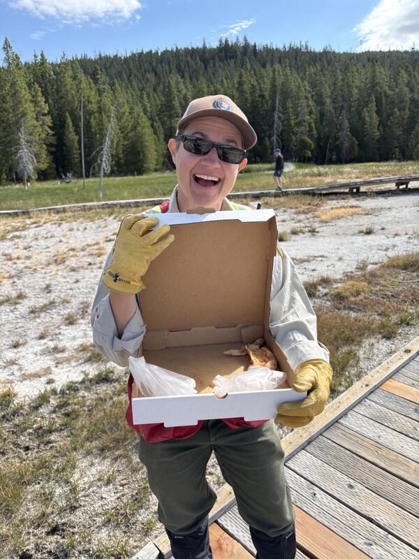
Removing trash from Geyser Hill, Yellowstone National Park
Removing trash from Geyser Hill, Yellowstone National ParkYellowstone National Park Geology Program volunteer Tara Cross smiles and shows off a pizza box found on Geyser Hill in Upper Geyser Basin. National Park Service photo by Margery Price, August 2025.
Sampling thermophilic cyanobacteria from a hot spring in Yellowstone's Lower Geyser Basin
Sampling thermophilic cyanobacteria from a hot spring in Yellowstone's Lower Geyser BasinA researcher collects a sample of thermophilic cyanobacteria from a hot spring in Yellowstone's Lower Geyser Basin. National Park Service photo by Samantha Hilburn, August 2025.
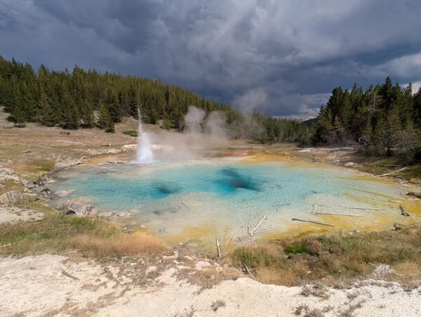
Imperial Geyser in eruption, Yellowstone National Park
Imperial Geyser in eruption, Yellowstone National ParkImperial Geyser in eruption. The geyser, which apparently formed in 1927, is located in Lower Geyser Basin, Yellowstone National Park.
Imperial Geyser in eruption, Yellowstone National Park
Imperial Geyser in eruption, Yellowstone National ParkImperial Geyser in eruption. The geyser, which apparently formed in 1927, is located in Lower Geyser Basin, Yellowstone National Park.
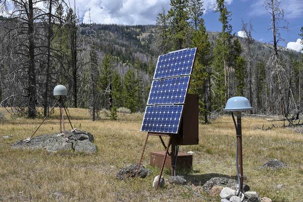
GPS station P712 near the northwest corner of Yellowstone National Park
GPS station P712 near the northwest corner of Yellowstone National ParkGPS station P712 near the northwest corner of Yellowstone National Park. The gray dome on the left is the GPS antenna, the electronics are located in the brown boxes, and the small gray dome on the right is the satellite antenna used to transmit data to the online archive for processing and analysis. Photo by Scott Johnson, EarthScope Consortium, July 30, 2025.
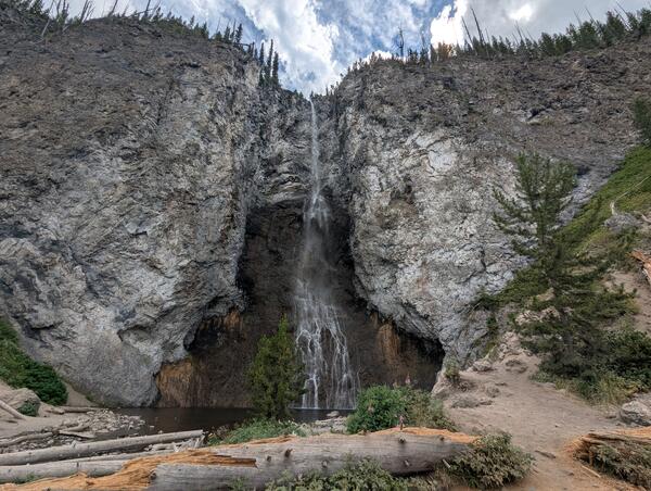
Fairy Falls, Yellowstone National Park
Fairy Falls, a 200-foot-high (60 meters) waterfall over rhyolite cliffs in the Lower Geyser Basin of Yellowstone National Park.
Fairy Falls, a 200-foot-high (60 meters) waterfall over rhyolite cliffs in the Lower Geyser Basin of Yellowstone National Park.
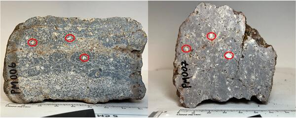
Samples of Lava Creek Tuff (Yellowstone caldera) with quartz and sanidine crystals indicated
Samples of Lava Creek Tuff (Yellowstone caldera) with quartz and sanidine crystals indicatedSamples of Lava Creek Tuff, which erupted during the formation of Yellowstone Caldera about 631,000 years ago, with large quartz and sanidine crystals circled in red. Photos by Faith Nolander, July 22, 2025.
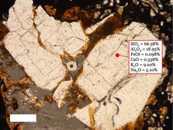
Microscope view of a sanidine crystal from the Lava Creek Tuff (Yellowstone caldera) with geochemical composition indicated for a point measured by electron microprobe analysis
Microscope view of a sanidine crystal from the Lava Creek Tuff (Yellowstone caldera) with geochemical composition indicated for a point measured by electron microprobe analysisA close-up (microscope) image of a sanidine crystal from the Lava Creek Tuff, which erupted during the formation of Yellowstone Caldera about 631,000 years ago, marked with a point where electron microprobe analysis was performed. The chemistry of that point is given, where each major element has a corresponding weight percent.
Microscope view of a sanidine crystal from the Lava Creek Tuff (Yellowstone caldera) with geochemical composition indicated for a point measured by electron microprobe analysis
Microscope view of a sanidine crystal from the Lava Creek Tuff (Yellowstone caldera) with geochemical composition indicated for a point measured by electron microprobe analysisMicroscope view of a sanidine crystal from the Lava Creek Tuff (Yellowstone caldera) with geochemical composition indicated for a point measured by electron microprobe analysis
Microscope view of a sanidine crystal from the Lava Creek Tuff (Yellowstone caldera) with geochemical composition indicated for a point measured by electron microprobe analysisA close-up (microscope) image of a sanidine crystal from the Lava Creek Tuff, which erupted during the formation of Yellowstone Caldera about 631,000 years ago, marked with a point where electron microprobe analysis was performed. The chemistry of that point is given, where each major element has a corresponding weight percent.

Example of Yellowstone seismic data showing sequence of small earthquakes for which a magnitude could not be determined
Example of Yellowstone seismic data showing sequence of small earthquakes for which a magnitude could not be determinedExample of a Yellowstone seismic waveform recorded at station YMC (at Maple Creek in the northeast part of Yellowstone National Park) with earthquakes for which a magnitude could not be determined. The magnitude was therefore set at -9.99 in the University of Utah Seismograph Stations catalog.