
A USGS scientist walks in the marsh at Summer Lake Wildlife Area to collect discrete water quality monitoring measurements.
Multimedia
If you are unable to access or download a product, email SalineLakeEcosystemsIWAA@usgs.gov.
Images

Discrete monitoring in Summer Lake Wildlife Area
A USGS scientist walks in the marsh at Summer Lake Wildlife Area to collect discrete water quality monitoring measurements.

Measuring reflectance of a playa
A scientists POV as they collect reflectance measurements of the Summer Lake playa. These measurements are used to test how well mud is distinguished from shallow surface water in satellite imagery.
A scientists POV as they collect reflectance measurements of the Summer Lake playa. These measurements are used to test how well mud is distinguished from shallow surface water in satellite imagery.

Continuous monitoring in Lake Abert
A USGS scientist wades into Lake Abert to service continuous water quality monitoring equipment.
A USGS scientist wades into Lake Abert to service continuous water quality monitoring equipment.

American avocet gets GPS tag
An American avocet is banded with a GPS tag during field research. A soft sock is placed over the bird’s head to reduce stress and keep it calm during handling.
An American avocet is banded with a GPS tag during field research. A soft sock is placed over the bird’s head to reduce stress and keep it calm during handling.

Summer Lake field work
A USGS scientist wearing a safety vest and earmuffs conducts field research at Summer Lake from an airboat. Airboats help USGS navigate shallow, muddy lakes and other challenging environments during critical studies.
A USGS scientist wearing a safety vest and earmuffs conducts field research at Summer Lake from an airboat. Airboats help USGS navigate shallow, muddy lakes and other challenging environments during critical studies.
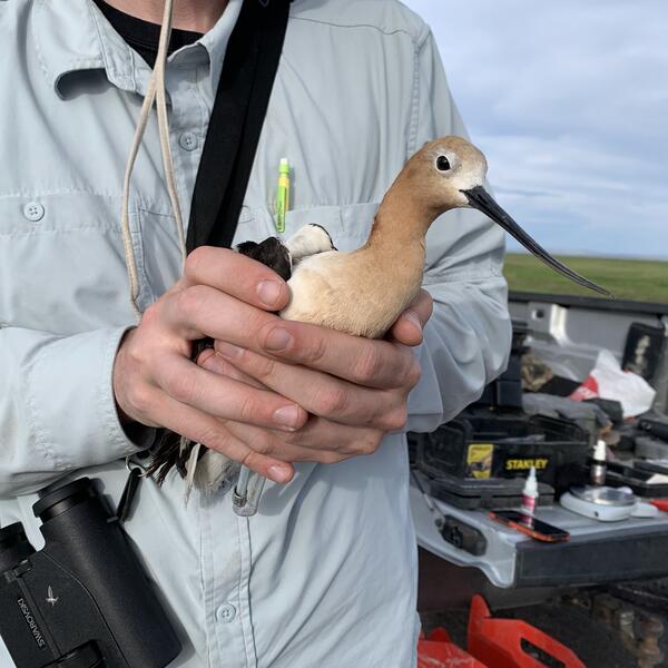
American avocet captured for research
An American avocet is held briefly before a GPS tag is attached as part of field research to track movement and habitat use.
An American avocet is held briefly before a GPS tag is attached as part of field research to track movement and habitat use.
Videos

Saline Lake Ecosystems IWAA Spring Seminar: Project Updates and 2025 Field Season Plans
Saline Lake Ecosystems IWAA Spring Seminar: Project Updates and 2025 Field Season PlansThis video presents the Spring 2025 Saline Lake Ecosystems Integrated Water Availability Assessment Spring Seminar by the U.S. Geological Survey (USGS). Hosted by Allison Shipp, the seminar provides updates on how hydroclimatic changes and water management affect terminal lake ecosystems and waterbird populations.

Saline Lakes IWAA Fall 2024 Webinar Series: Satellite Observations of Lake Surface Water Dynamics
Saline Lakes IWAA Fall 2024 Webinar Series: Satellite Observations of Lake Surface Water DynamicsThe sixth and final webinar in the Saline Lakes Ecosystems IWAA Fall 2024 Webinar Series is on satellite observations of lake surface water dynamics. John W. Jones of the USGS Hydrologic Remote Sensing Branch introduces the surface water and wetland remote sensing component of the Integrated Water Availability Assessment.
By
Ecosystems Mission Area, Water Resources Mission Area, Species Management Research Program, Water Availability and Use Science Program, Forest and Rangeland Ecosystem Science Center, Fort Collins Science Center, Nevada Water Science Center, Oregon Water Science Center, Utah Water Science Center, Western Ecological Research Center (WERC), Saline Lake Ecosystems Integrated Water Availability Assessment

Saline Lakes IWAA Fall 2024 Webinar Series: Waterbird Prey Availability
Saline Lakes IWAA Fall 2024 Webinar Series: Waterbird Prey AvailabilityThe fifth webinar in the Saline Lakes Ecosystems IWAA Fall 2024 Webinar Series is on waterbird prey availability in Great Basin terminal lakes.
By
Ecosystems Mission Area, Water Resources Mission Area, Species Management Research Program, Water Availability and Use Science Program, Forest and Rangeland Ecosystem Science Center, Fort Collins Science Center, Nevada Water Science Center, Oregon Water Science Center, Utah Water Science Center, Western Ecological Research Center (WERC), Saline Lake Ecosystems Integrated Water Availability Assessment

Saline Lakes Ecosystems IWAA Fall 2024 Webinar Series: Bird Movements
Saline Lakes Ecosystems IWAA Fall 2024 Webinar Series: Bird MovementsThe fourth webinar in the Saline Lakes Ecosystems IWAA Fall 2024 Webinar Series is on movement of bird species associated with Great Basin terminal lake ecosystems. Cory Overton of the Western Ecological Research Center gives an overview of the USGS bird movement monitoring strategy and presents results from the 2024 field season.
By
Ecosystems Mission Area, Water Resources Mission Area, Species Management Research Program, Water Availability and Use Science Program, Forest and Rangeland Ecosystem Science Center, Fort Collins Science Center, Nevada Water Science Center, Oregon Water Science Center, Utah Water Science Center, Western Ecological Research Center (WERC), Saline Lake Ecosystems Integrated Water Availability Assessment

Saline Lakes Ecosystems IWAA Fall 2024 Webinar Series: Water-Quality Monitoring of Great Basin Terminal Lake Ecosystems
Saline Lakes Ecosystems IWAA Fall 2024 Webinar Series: Water-Quality Monitoring of Great Basin Terminal Lake EcosystemsThe third webinar in the Saline Lakes Ecosystems IWAA Fall 2024 Webinar Series is on water-quality monitoring of Great Basin terminal lake ecosystems. Christine Rumsey of the Utah Water Science Center and Casie Smith of the Oregon Water Science Center give an overview of the USGS water-quality monitoring strategy and present results from the 2024 field season.
By
Ecosystems Mission Area, Water Resources Mission Area, Species Management Research Program, Water Availability and Use Science Program, Forest and Rangeland Ecosystem Science Center, Fort Collins Science Center, Nevada Water Science Center, Oregon Water Science Center, Utah Water Science Center, Western Ecological Research Center (WERC), Saline Lake Ecosystems Integrated Water Availability Assessment

Saline Lake Ecosystems IWAA Fall 2024 Webinar Series: Physical and Chemical Monitoring in Support of Water Budgets of Select Great Basin Saline Lakes
Saline Lake Ecosystems IWAA Fall 2024 Webinar Series: Physical and Chemical Monitoring in Support of Water Budgets of Select Great Basin Saline LakesThe second webinar in the Saline Lake Ecosystems IWAA Fall 2024 Webinar Series is on physical and chemical monitoring in support of water budgets of select Great Basin saline lakes.
By
Ecosystems Mission Area, Water Resources Mission Area, Species Management Research Program, Water Availability and Use Science Program, Forest and Rangeland Ecosystem Science Center, Fort Collins Science Center, Nevada Water Science Center, Oregon Water Science Center, Utah Water Science Center, Western Ecological Research Center (WERC), Saline Lake Ecosystems Integrated Water Availability Assessment