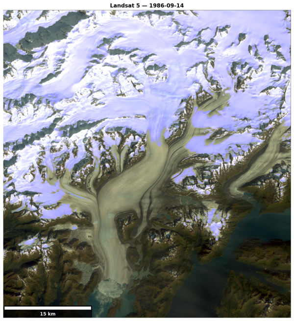
Left image: Landsat 5 image of Columbia Glacier, Alaska on Sept. 14, 1986.
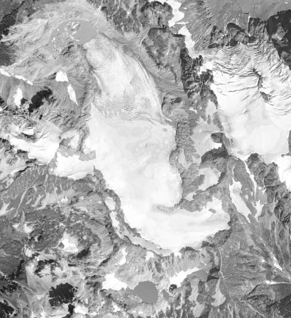
Right image: Landsat 9 image of Columbia Glacier, Alaska on Sept. 17, 2025.

Official websites use .gov
A .gov website belongs to an official government organization in the United States.
Secure .gov websites use HTTPS
A lock () or https:// means you’ve safely connected to the .gov website. Share sensitive information only on official, secure websites.
My research focuses on understanding the ways glaciers change in area, volume, and mass at basin-to-regional spatial scales, and how those changes impact local ecosystems and global sea level.
My projects synthesize both in-situ and remotely sensed data of glacier change ranging from Alaska to the Contiguous United States. Research includes reanalyzing the longest in-situ records of glacier change in North America to homogenize the U.S. Geological Survey’s traditional glacier monitoring network. Additionally, my research extends to understanding the factors (hypsometry, snow accumulation patterns, energy balances, dynamic processes) that drive variable glacier change rates at the mountain range scale. This work leverages historical aerial imagery, high resolution commercial satellite imagery, open-source computing platforms, geospatial analyses, and high-performance computing.


Left image: Landsat 5 image of Columbia Glacier, Alaska on Sept. 14, 1986.
Right image: Landsat 9 image of Columbia Glacier, Alaska on Sept. 17, 2025.
Left image: Landsat 5 image of Columbia Glacier, Alaska on Sept. 14, 1986.
Right image: Landsat 9 image of Columbia Glacier, Alaska on Sept. 17, 2025.
Left image: Aerial image of Taku Glacier in 1948. The Norris Glacier can be seen on the lower left hand corner and the Hole-in-the-Wall Glacier in the upper center portion of the image. Citation: McNeil, C. J., and Baker, E.
Left image: Aerial image of Taku Glacier in 1948. The Norris Glacier can be seen on the lower left hand corner and the Hole-in-the-Wall Glacier in the upper center portion of the image. Citation: McNeil, C. J., and Baker, E.
Aerial photograph of South Cascade Glacier, WA taken August 13th, 1958 (before image) and October 14th, 2015 (after image).
Aerial photograph of South Cascade Glacier, WA taken August 13th, 1958 (before image) and October 14th, 2015 (after image).
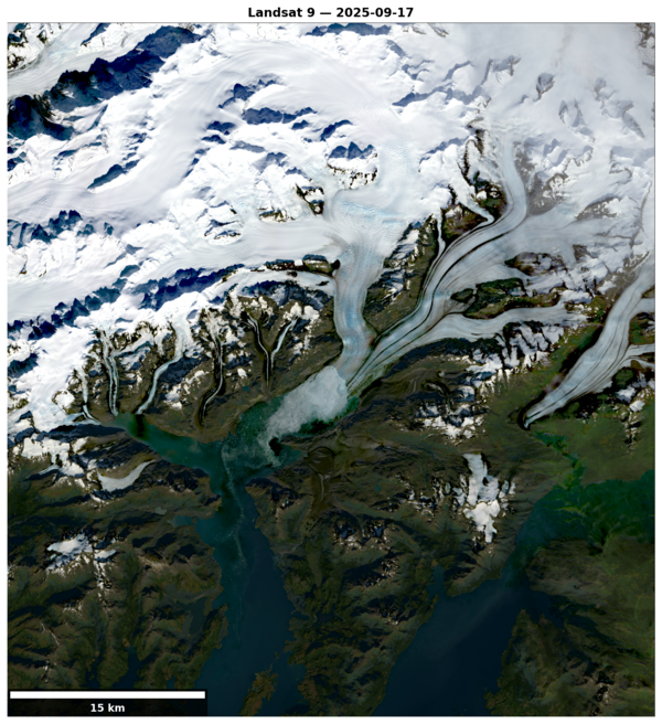
Landsat 9 image of Columbia Glacier, Alaska on Sept. 17, 2025.
Landsat 9 image of Columbia Glacier, Alaska on Sept. 17, 2025.

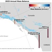
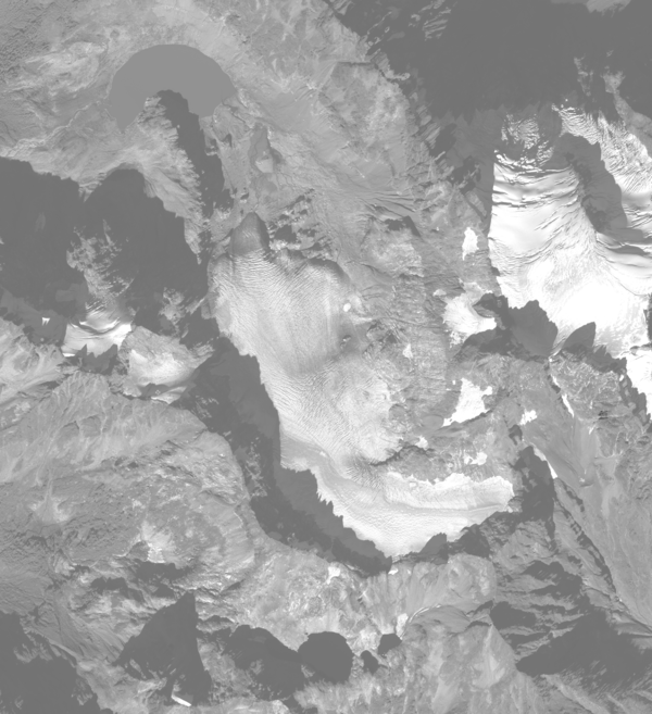
Gulkana Glacier area change, from 1957 - 2021. Gulkana Glacier is located along the south flank of the eastern Alaska Range.
Gulkana Glacier area change, from 1957 - 2021. Gulkana Glacier is located along the south flank of the eastern Alaska Range.

2019 Juneau Icefield Research Program (JIRP) students during a four day and 83 kilometers ski traverse across Taku Glacier, carrying all their food, water, clothing, tents, and science gear as they help measure the mass balance along the way.
2019 Juneau Icefield Research Program (JIRP) students during a four day and 83 kilometers ski traverse across Taku Glacier, carrying all their food, water, clothing, tents, and science gear as they help measure the mass balance along the way.

Students Stacey Edmonsond (left) and Audrey Erickson (right) of the Juneau Icefield Research Program, measuring glacier mass balance at the flow divide of Taku and Mendenhall glaciers during the summer of 2019
Students Stacey Edmonsond (left) and Audrey Erickson (right) of the Juneau Icefield Research Program, measuring glacier mass balance at the flow divide of Taku and Mendenhall glaciers during the summer of 2019

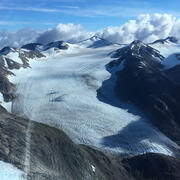
Image of the Taku towers, among the Taku Range at Taku Glacier during the summer of 2019
Image of the Taku towers, among the Taku Range at Taku Glacier during the summer of 2019

Satellite image of Taku Glacier in October 1, 2018. The Norris Glacier can be seen on the lower left hand corner and the Hole-in-the-Wall Glacier in the upper center portion of the image. Citation: McNeil, C. J., and Baker, E.
Satellite image of Taku Glacier in October 1, 2018. The Norris Glacier can be seen on the lower left hand corner and the Hole-in-the-Wall Glacier in the upper center portion of the image. Citation: McNeil, C. J., and Baker, E.

Satellite image of Taku Glacier in October 1, 2018. The Norris Glacier can be seen on the lower left hand corner and the Hole-in-the-Wall Glacier in the upper center portion of the image.
Satellite image of Taku Glacier in October 1, 2018. The Norris Glacier can be seen on the lower left hand corner and the Hole-in-the-Wall Glacier in the upper center portion of the image.
Aerial photograph of South Cascade Glacier, WA taken October 14th, 2015.
Aerial photograph of South Cascade Glacier, WA taken October 14th, 2015.

Aerial image of Taku Glacier in 1948. The Norris Glacier can be seen on the lower left hand corner and the Hole-in-the-Wall Glacier in the upper center portion of the image. Citation: McNeil, C. J., and Baker, E. H., 2019, Geodetic data for Juneau Icefield Glaciers: orthophotos, digital elevation models, and glacier boundaries (ver 1.0, August, 2019): U.S.
Aerial image of Taku Glacier in 1948. The Norris Glacier can be seen on the lower left hand corner and the Hole-in-the-Wall Glacier in the upper center portion of the image. Citation: McNeil, C. J., and Baker, E. H., 2019, Geodetic data for Juneau Icefield Glaciers: orthophotos, digital elevation models, and glacier boundaries (ver 1.0, August, 2019): U.S.
Landsat 5 image of Columbia Glacier, Alaska on Sept. 14, 1986.
Landsat 5 image of Columbia Glacier, Alaska on Sept. 14, 1986.
Aerial photograph of South Cascade Glacier, WA taken August 13th, 1958.
Aerial photograph of South Cascade Glacier, WA taken August 13th, 1958.
Left image: Landsat 5 image of Columbia Glacier, Alaska on Sept. 14, 1986.
Right image: Landsat 9 image of Columbia Glacier, Alaska on Sept. 17, 2025.
Left image: Landsat 5 image of Columbia Glacier, Alaska on Sept. 14, 1986.
Right image: Landsat 9 image of Columbia Glacier, Alaska on Sept. 17, 2025.
Left image: Aerial image of Taku Glacier in 1948. The Norris Glacier can be seen on the lower left hand corner and the Hole-in-the-Wall Glacier in the upper center portion of the image. Citation: McNeil, C. J., and Baker, E.
Left image: Aerial image of Taku Glacier in 1948. The Norris Glacier can be seen on the lower left hand corner and the Hole-in-the-Wall Glacier in the upper center portion of the image. Citation: McNeil, C. J., and Baker, E.
Aerial photograph of South Cascade Glacier, WA taken August 13th, 1958 (before image) and October 14th, 2015 (after image).
Aerial photograph of South Cascade Glacier, WA taken August 13th, 1958 (before image) and October 14th, 2015 (after image).
Landsat 9 image of Columbia Glacier, Alaska on Sept. 17, 2025.
Landsat 9 image of Columbia Glacier, Alaska on Sept. 17, 2025.
Gulkana Glacier area change, from 1957 - 2021. Gulkana Glacier is located along the south flank of the eastern Alaska Range.
Gulkana Glacier area change, from 1957 - 2021. Gulkana Glacier is located along the south flank of the eastern Alaska Range.
2019 Juneau Icefield Research Program (JIRP) students during a four day and 83 kilometers ski traverse across Taku Glacier, carrying all their food, water, clothing, tents, and science gear as they help measure the mass balance along the way.
2019 Juneau Icefield Research Program (JIRP) students during a four day and 83 kilometers ski traverse across Taku Glacier, carrying all their food, water, clothing, tents, and science gear as they help measure the mass balance along the way.
Students Stacey Edmonsond (left) and Audrey Erickson (right) of the Juneau Icefield Research Program, measuring glacier mass balance at the flow divide of Taku and Mendenhall glaciers during the summer of 2019
Students Stacey Edmonsond (left) and Audrey Erickson (right) of the Juneau Icefield Research Program, measuring glacier mass balance at the flow divide of Taku and Mendenhall glaciers during the summer of 2019
Image of the Taku towers, among the Taku Range at Taku Glacier during the summer of 2019
Image of the Taku towers, among the Taku Range at Taku Glacier during the summer of 2019
Satellite image of Taku Glacier in October 1, 2018. The Norris Glacier can be seen on the lower left hand corner and the Hole-in-the-Wall Glacier in the upper center portion of the image. Citation: McNeil, C. J., and Baker, E.
Satellite image of Taku Glacier in October 1, 2018. The Norris Glacier can be seen on the lower left hand corner and the Hole-in-the-Wall Glacier in the upper center portion of the image. Citation: McNeil, C. J., and Baker, E.
Satellite image of Taku Glacier in October 1, 2018. The Norris Glacier can be seen on the lower left hand corner and the Hole-in-the-Wall Glacier in the upper center portion of the image.
Satellite image of Taku Glacier in October 1, 2018. The Norris Glacier can be seen on the lower left hand corner and the Hole-in-the-Wall Glacier in the upper center portion of the image.
Aerial photograph of South Cascade Glacier, WA taken October 14th, 2015.
Aerial photograph of South Cascade Glacier, WA taken October 14th, 2015.
Aerial image of Taku Glacier in 1948. The Norris Glacier can be seen on the lower left hand corner and the Hole-in-the-Wall Glacier in the upper center portion of the image. Citation: McNeil, C. J., and Baker, E. H., 2019, Geodetic data for Juneau Icefield Glaciers: orthophotos, digital elevation models, and glacier boundaries (ver 1.0, August, 2019): U.S.
Aerial image of Taku Glacier in 1948. The Norris Glacier can be seen on the lower left hand corner and the Hole-in-the-Wall Glacier in the upper center portion of the image. Citation: McNeil, C. J., and Baker, E. H., 2019, Geodetic data for Juneau Icefield Glaciers: orthophotos, digital elevation models, and glacier boundaries (ver 1.0, August, 2019): U.S.
Landsat 5 image of Columbia Glacier, Alaska on Sept. 14, 1986.
Landsat 5 image of Columbia Glacier, Alaska on Sept. 14, 1986.
Aerial photograph of South Cascade Glacier, WA taken August 13th, 1958.
Aerial photograph of South Cascade Glacier, WA taken August 13th, 1958.