
Land Application of Drilling Fluids in Oklahoma: Data Viewer
July 9, 2025
Media
Sources/Usage: Public Domain. View Media Details
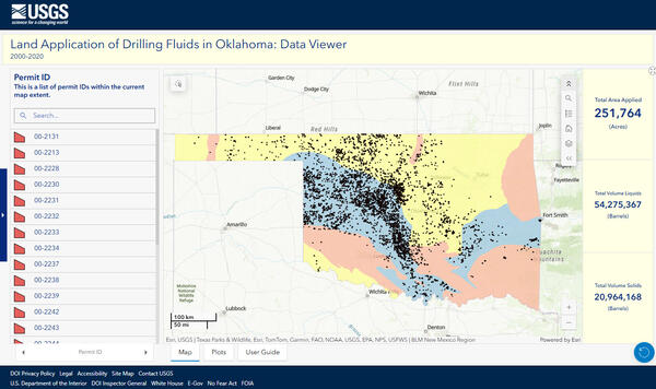
The data presented here include the total area of land where drilling wastes were applied, the total volume of solid and liquid deposits, and volume of oil-based and water-based fluid deposits.
Data are presented at the Public Land Survey System (PLSS) section scale throughout Oklahoma between the years 2000 to 2020 and can be filtered by year and/or permit identification number.
Summarized data (sum of all drill fluid deposits) are also presented at the township, county, and geologic province level.
Land application data hosted on this dashboard were digitized at the statewide scale and include data for years 2020, 2005, 2010, and 2015-2020.
Data are available for download in a comma-separated value file from a USGS data release (https://doi.org/10.5066/P9MLW0G6).