U.S. flag

An official website of the United States government

Images

Kīlauea images of eruptive activity, field work, and more.

Filter Total Items: 2978
Color photograph of two scientists collecting samples from cooled lava flows
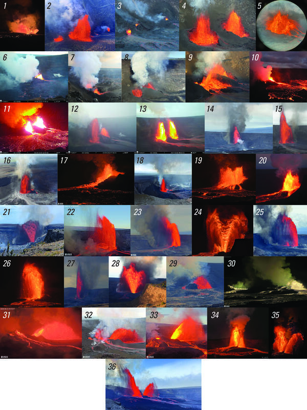
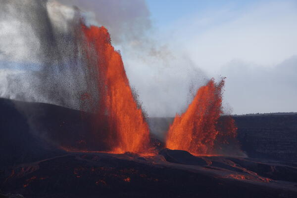
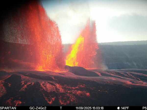
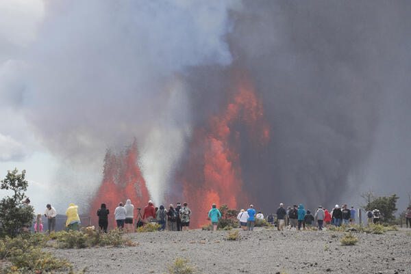
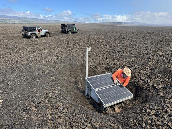
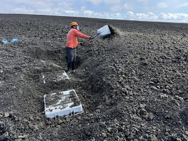
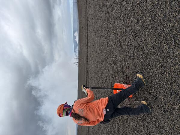
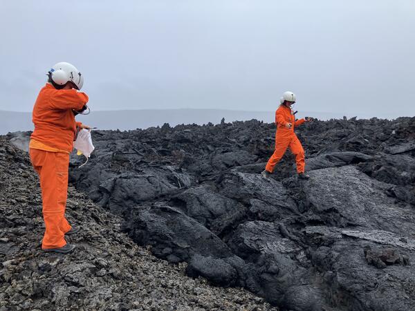
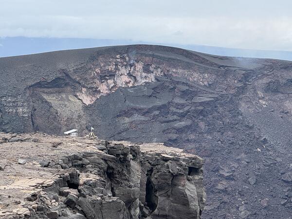
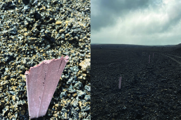
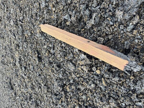
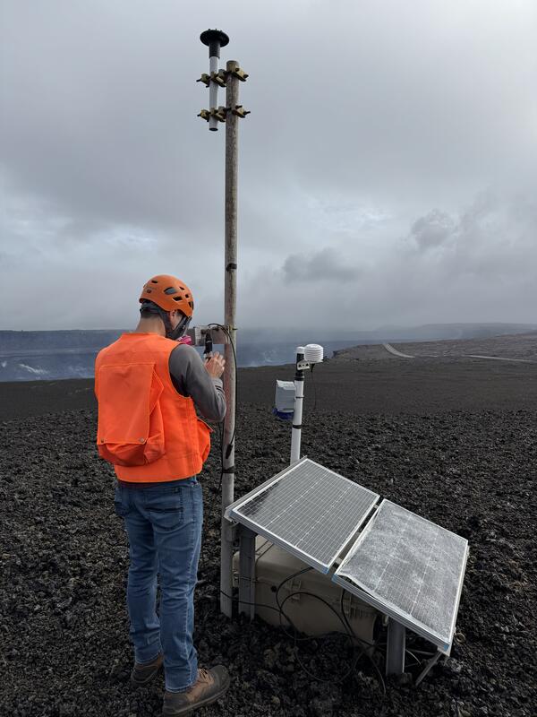
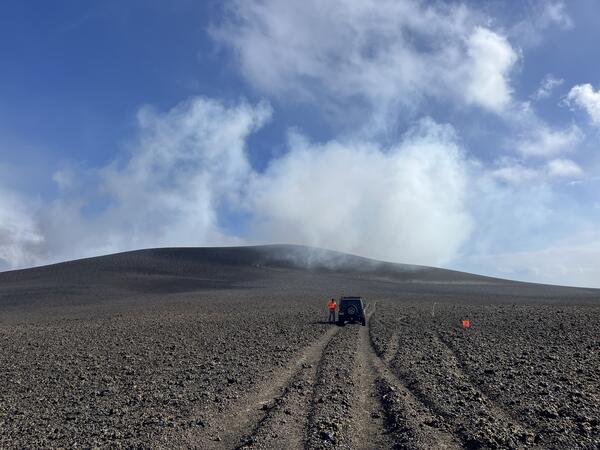
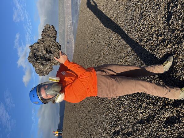
November 21, 2025 — Scientists on floor of Halema‘uma‘u

With permission from Hawai‘i Volcanoes National Park, USGS Hawaiian Volcano Observatory scientists landed briefly on the floor of Halema‘uma‘u crater on November 21 to collect lava samples from Kīlauea summit eruption episodes 34, 35, and 36.

With permission from Hawai‘i Volcanoes National Park, USGS Hawaiian Volcano Observatory scientists landed briefly on the floor of Halema‘uma‘u crater on November 21 to collect lava samples from Kīlauea summit eruption episodes 34, 35, and 36.

Color photograph of volcanic hill
November 18, 2025 — Kīlauea summit cone slumping

This photo, taken on November 18 from the south rim of Halemaʻumaʻu crater, shows slumping of material from the hill formed by fallout from the recent lava fountains at Kīlauea summit. The v3cam livestream camera is visible on the rim of the crater in the middle left of the image. USGS photo by M. Patrick.

This photo, taken on November 18 from the south rim of Halemaʻumaʻu crater, shows slumping of material from the hill formed by fallout from the recent lava fountains at Kīlauea summit. The v3cam livestream camera is visible on the rim of the crater in the middle left of the image. USGS photo by M. Patrick.

Color photograph of damaged post in fragmented material; posts along road of fragmented material
November 17, 2025 — Road marker damaged during episode 36 of Kīlauea's ongoing summit eruption

This plastic road marker shown on the left side of this photo was found on the side of Crater Rim Drive within the hazardous closed area of Hawai‘i Volcanoes National Park, downwind of the episodically erupting vents within Halema‘uma‘u crater.

Color photograph of two scientists measuring a crack in a road
November 17, 2025 — Measuring a crack in Crater Rim Drive

The west portion of Crater Rim Drive in Hawaiʻi Volcanoes National Park was damaged during the Kīlauea summit collapse of 2018. This area has remained closed to the public, being impacted by tephrafall and volcanic gas during recent eruptions. U.S.

The west portion of Crater Rim Drive in Hawaiʻi Volcanoes National Park was damaged during the Kīlauea summit collapse of 2018. This area has remained closed to the public, being impacted by tephrafall and volcanic gas during recent eruptions. U.S.

Color photograph of volcanic landscape
November 17, 2025 — Puʻu perched on the rim of Halemaʻumaʻu

Lava fountains from 36 episodes of the ongoing eruption in Halemaʻumaʻu crater, at the summit of Kīlauea, have built a prominent new puʻu (made up of tephra) perched on the rim of the crater. In the foreground, tephra covers part of Crater Rim Drive in this closed area of Hawaiʻi Volcanoes National Park. USGS photo by N. Kohagura. 

Lava fountains from 36 episodes of the ongoing eruption in Halemaʻumaʻu crater, at the summit of Kīlauea, have built a prominent new puʻu (made up of tephra) perched on the rim of the crater. In the foreground, tephra covers part of Crater Rim Drive in this closed area of Hawaiʻi Volcanoes National Park. USGS photo by N. Kohagura. 

Color photograph of damaged post
November 17, 2025 — Wooden post damaged by episode 36 of ongoing Kīlauea eruption

This wooden post used to mark the side of Crater Rim Drive within a hazardous closed area of Hawai‘i Volcanoes National Park. The post has been slowly buried by tephra from lava fountains that have been episodically active during the ongoing eruption of Kīlauea at Halema‘uma‘u that started on December 23, 2025.

This wooden post used to mark the side of Crater Rim Drive within a hazardous closed area of Hawai‘i Volcanoes National Park. The post has been slowly buried by tephra from lava fountains that have been episodically active during the ongoing eruption of Kīlauea at Halema‘uma‘u that started on December 23, 2025.

Color photograph of scientist checking monitoring equipment
November 17, 2025 — Checking Kīlauea summit monitoring equipment

A U.S. Geological Survey Hawaiian Volcano Observatory geologists checks the status of one of the Kīlauea monitoring stations downwind of the active vents in Halemaʻumaʻu. This station has been buried incrementally by tephra as a result of lava fountaining, and solar panels were damaged by tephra impact. USGS photo by N. Kohagura.

A U.S. Geological Survey Hawaiian Volcano Observatory geologists checks the status of one of the Kīlauea monitoring stations downwind of the active vents in Halemaʻumaʻu. This station has been buried incrementally by tephra as a result of lava fountaining, and solar panels were damaged by tephra impact. USGS photo by N. Kohagura.

Color graphic with 36 smaller images of volcanic eruptions
Photo compilation of episodes 1–36 of the ongoing eruption at the summit of Kīlauea

Photo compilation of episodes 1–36 of the ongoing eruption at the summit of Kīlauea, including webcam imagery and photos taken by USGS Hawaiian Volcano Observatory scientists on the ground and during helicopter overflights. In all photos except for episode 7, the south vent is on the left and the north vent is on the right.

Photo compilation of episodes 1–36 of the ongoing eruption at the summit of Kīlauea, including webcam imagery and photos taken by USGS Hawaiian Volcano Observatory scientists on the ground and during helicopter overflights. In all photos except for episode 7, the south vent is on the left and the north vent is on the right.

Color photograph of fine particles of volcanic glass on a paved road
November 10, 2025 — Pele's hair in Pāhala from Kīlauea episode 36

Episode 36 lava fountaining from Kīlauea's ongoing summit eruption formed tephra, including Pele's hair (strands of fine volcanic glass). Winds blowing from the north resulted in Pele's hair being deposited in Pāhala, a town about 20 miles (32 km) to the southwest of the eruptive vents in Halema‘uma‘u.

Episode 36 lava fountaining from Kīlauea's ongoing summit eruption formed tephra, including Pele's hair (strands of fine volcanic glass). Winds blowing from the north resulted in Pele's hair being deposited in Pāhala, a town about 20 miles (32 km) to the southwest of the eruptive vents in Halema‘uma‘u.

Color photograph of volcanic hill with road and vehicle in the foreground
November 10, 2025 — View of the growing tephra hill after episode 36 at Kīlauea

The day after episode 36 of the ongoing Kīlauea eruption, USGS geologists inspected the tephra deposit west of Halema‘uma‘u, in the closed area of Hawai‘i Volcanoes National Park. This photo looks south, with Halema‘uma‘u out of view to the left.

The day after episode 36 of the ongoing Kīlauea eruption, USGS geologists inspected the tephra deposit west of Halema‘uma‘u, in the closed area of Hawai‘i Volcanoes National Park. This photo looks south, with Halema‘uma‘u out of view to the left.

Color photograph of scientist holding recently erupted volcanic rock
September 30, 2025 — Tephra clast erupted during episode 33 of Kīlauea summit eruption

During the lava fountains of episode 33 on September 19, tephra particles traveled through the air and fell downwind west of Halema‘uma‘u. This clast was about 16 inches (40 centimeters) long, very lightweight due to being very bubble-rich, and delicate. USGS photo by N. Deligne.

During the lava fountains of episode 33 on September 19, tephra particles traveled through the air and fell downwind west of Halema‘uma‘u. This clast was about 16 inches (40 centimeters) long, very lightweight due to being very bubble-rich, and delicate. USGS photo by N. Deligne.

Color photograph of dual lava fountains
November 9, 2025 — Kīlauea episode 36 lava fountaining

View of the dual fountains during episode 36 at the summit of Kīlauea, on Sunday, November 9. View is from the south rim of Halema‘uma‘u crater. Peak heights of lava fountains erupted during this episode reached about 350 meters (1150 feet). USGS photo by M. Patrick.

View of the dual fountains during episode 36 at the summit of Kīlauea, on Sunday, November 9. View is from the south rim of Halema‘uma‘u crater. Peak heights of lava fountains erupted during this episode reached about 350 meters (1150 feet). USGS photo by M. Patrick.

Color photograph of lava fountaining from two volcanic vents
November 9, 2025 — Kīlauea Episode 36

This image, captured on November 9, 2025, by the USGS Hawaiian Volcano Observatory S2cam, shows lava fountaining from the north and south vents during episode 36 of ongoing eruption at the summit of Kīlauea. Episode 36 lava fountaining began at 11:15 a.m. on November 9 and was over just 5 hours later, at 4:16 p.m. that same day.

This image, captured on November 9, 2025, by the USGS Hawaiian Volcano Observatory S2cam, shows lava fountaining from the north and south vents during episode 36 of ongoing eruption at the summit of Kīlauea. Episode 36 lava fountaining began at 11:15 a.m. on November 9 and was over just 5 hours later, at 4:16 p.m. that same day.

Color photograph of scientists walking on damaged road with lava fountains in the background
November 9, 2025 — Kīlauea episode 36 monitoring

USGS Hawaiian Volcano Observatory geologists approach the south rim of Halema‘uma‘u crater to make observations of episode 36 at the summit of Kīlauea. This section of Crater Rim Drive within Hawai‘i Volcanoes National Park was damaged in the 2018 summit collapse, and remains closed to the public. USGS photo by M. Patrick on November 9.

USGS Hawaiian Volcano Observatory geologists approach the south rim of Halema‘uma‘u crater to make observations of episode 36 at the summit of Kīlauea. This section of Crater Rim Drive within Hawai‘i Volcanoes National Park was damaged in the 2018 summit collapse, and remains closed to the public. USGS photo by M. Patrick on November 9.

Color photograph of people standing on the rim of a crater with lava fountains in the background
November 9, 2025 — Kīlauea

Hawai‘i Volcanoes National Park visitors watch the lava fountains from Uēkahuna overlook on Sunday, November 9. USGS photo by M. Patrick.

Hawai‘i Volcanoes National Park visitors watch the lava fountains from Uēkahuna overlook on Sunday, November 9. USGS photo by M. Patrick.

Color photograph of person fixing monitoring station
October 21, 2025 — Kīlauea summit monitoring station maintenance

A USGS Hawaiian Volcano Observatory field engineer conducts repairs on a gas sensor downwind of the eruptive vents at Kīlauea summit, after digging out tephra that partially buried the instrument during episode 35 lava fountaining. Photo taken October 21, 2025, by M. Patrick.

A USGS Hawaiian Volcano Observatory field engineer conducts repairs on a gas sensor downwind of the eruptive vents at Kīlauea summit, after digging out tephra that partially buried the instrument during episode 35 lava fountaining. Photo taken October 21, 2025, by M. Patrick.

Color photograph of person digging a box out of the ground
October 21, 2025 — Repairing Kīlauea summit monitoring stations

On October 21, a USGS Hawaiian Volcano Observatory field engineer dug out monitoring equipment buried by tephra fallout from the episode 35 lava fountaining. USGS photo by M. Patrick.

On October 21, a USGS Hawaiian Volcano Observatory field engineer dug out monitoring equipment buried by tephra fallout from the episode 35 lava fountaining. USGS photo by M. Patrick.

Webcam image of volcanic eruption
October 18, 2025 — Kīlauea summit eruption episode 35

This image, captured by the USGS Hawaiian Volcano Observatory KWcam, shows lava fountains erupting during episode 35 of the Kīlauea summit eruption. Dual lava fountains within Halemaʻumaʻu crater feed lava flows on the crater floor. USGS webcam image taken on October 18, 2025. 

This image, captured by the USGS Hawaiian Volcano Observatory KWcam, shows lava fountains erupting during episode 35 of the Kīlauea summit eruption. Dual lava fountains within Halemaʻumaʻu crater feed lava flows on the crater floor. USGS webcam image taken on October 18, 2025. 

Color photograph of lava fountaining
October 1, 2025 — Episode 34 of lava fountaining at Kīlauea summit

Just before dawn during episode 34 on October 1, 2025, the north and south vents both erupted, creating a spectacular column and sending lava flows over crater floor as viewed from USGS Hawaiian Volcano Observatory livestreaming V2cam. The north vent achieved a slightly higher fountain than the south at 383 meters (1256 feet). USGS photo. 

Just before dawn during episode 34 on October 1, 2025, the north and south vents both erupted, creating a spectacular column and sending lava flows over crater floor as viewed from USGS Hawaiian Volcano Observatory livestreaming V2cam. The north vent achieved a slightly higher fountain than the south at 383 meters (1256 feet). USGS photo. 

Color webcam image of lava fountains erupting
October 1, 2025 — Kīlauea summit eruption episode 34

This image, captured by the USGS Hawaiian Volcano Observatory K2cam, shows lava fountains erupting during episode 34 of the Kīlauea summit eruption. The lights in the foreground show the walkway to the Uēkahuna Overlook in HAWAII Volcanoes National Park. USGS webcam image taken on October 1, 2025. 

This image, captured by the USGS Hawaiian Volcano Observatory K2cam, shows lava fountains erupting during episode 34 of the Kīlauea summit eruption. The lights in the foreground show the walkway to the Uēkahuna Overlook in HAWAII Volcanoes National Park. USGS webcam image taken on October 1, 2025. 

Color photograph of scientist taking measurement on volcanic landscape
September 25, 2025 — Measuring changes in elevation across the new tephra cone at Kīlauea after episode 33

A USGS Hawaiian Volcano Observatory geologist surveys the elevation along a transect across the new tephra cone formed by the recent lava fountaining episodes at the summit of Kīlauea. Repeat measurements across the same set of points have been done after every episode starting with episode 23, to track the growth and changes of the tephra hill. USGS photo by M.

A USGS Hawaiian Volcano Observatory geologist surveys the elevation along a transect across the new tephra cone formed by the recent lava fountaining episodes at the summit of Kīlauea. Repeat measurements across the same set of points have been done after every episode starting with episode 23, to track the growth and changes of the tephra hill. USGS photo by M.

Was this page helpful?