An official website of the United States government
Here's how you know
Official websites use .gov
A .gov website belongs to an official government organization in the United States.
Secure .gov websites use HTTPS
A lock () or https:// means you’ve safely connected to the .gov website. Share sensitive information only on official, secure websites.
When it comes to the world’s water supply, effective management is vital. One of the challenges is understanding how much water crops and vegetation actually use. How much water is required? How much water is “too much”?
A USGS Landsat science product helps to provide that information at the scale of individual fields around the world. Using Landsat observations, the product estimates Actual Evapotranspiration, or ETa, the movement of water from the land surface and plants into the atmosphere. Knowing how much water is being consumed can help farmers and water managers make decisions about irrigation, water allocation and conservation.
A newUSGS publication evaluates the on-demand product and its performance across a range of landscapes and climates. The research demonstrates how more than four decades of Landsat observations can provide consistent ETa information for studying water use around the world.
The publication describes how Landsat Collection 2 Level-3 Provisional Actual Evapotranspiration products are developed, evaluated, and distributed for water use studies across global land surfaces. Findings demonstrate consistent product performance across diverse regions and reinforce the importance of maintaining high-quality, well-calibrated Landsat Thermal Infrared (TIR) data to deliver a mature ET algorithm for global application needs.
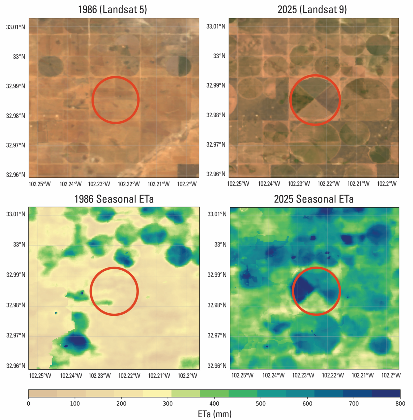
These images illustrate how Landsat Provisional Actual Evapotranspiration (ETa) data can be used to map and quantify changes in seasonal water‑use patterns (April–September). True‑color, 30‑meter images and their corresponding seasonal ETa maps are displayed for a field near Lubbock, Texas, in 1986 and 2025. Landsat Path 30, Row 37.
Scientists use the USGS-created Operational Simplified Surface Energy Balance (SSEBop) model, which computes actual ET for each pixel in a scene. The model calculates actual ET for each Landsat pixel using two independent components: ET Fraction and Reference ET. The resulting data can be used to estimate consumptive water use at field scale and support a wide range of agricultural and water‑resource applications.
The Landsat 4-9 record from 1982 to the present allows ETa products to deliver historical and ongoing views of continuous medium-resolution TIR observations at a resampled spatial scale of 30 × 30 meters (equating to just less than ¼ of an acre) per pixel. The product’s methodology combines Landsat surface temperature, reference ET, vegetation indices, and net radiation to deliver robust estimates.
Accessing and using ETa Information
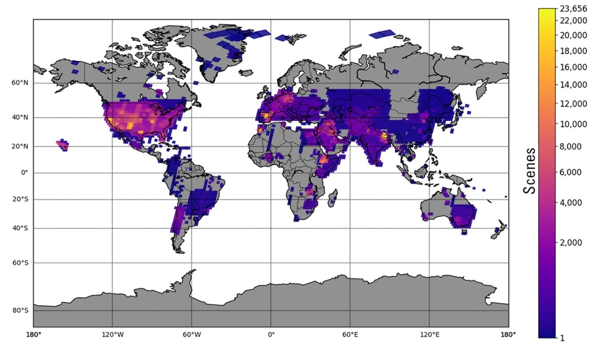
Landsat scene-based ETa products are categorized as provisional, meaning they are preliminary and subject to revision. They can be requested using the USGS EROS Science Processing Architecture (ESPA) on-demand interface. Between 2020 and 2025, more than 1.2 million ETa products were requested from ESPA. The map below provides a geographical look at the areas studied during this timeframe.
This heatmap displays the requests for Landsat Provisional Actual Evapotranspiration (ETa) products from 2020 through 2025.
Landsat ETa products provide access to consistent, field-scale evapotranspiration information globally, allowing users to study water in regions around the world. Landsat ETa data can also feed into more geographically focused applications. In the conterminous U.S., recent advances in serving ETa data with user-friendly platforms such as OpenEThave allowed integration of ET data with decision-making tools and procedures. Created through a partnership of scientists, water managers, technology experts, and nonprofit groups, OpenET provides transparent, field‑level satellite-based evapotranspiration data that helps farmers, water managers, and communities make more informed and sustainable water‑use decisions.
Evapotranspiration is the process by which water transpires from the leaves and stems of plants and evaporates from the Earth’s surface. ET is an important metric for managing water use, but data availability has long been an issue. On this episode of Eyes on Earth, we talk about OpenET, a bold initiative whose goal is to improve water management by making that water consumption data more easily...
Eyes on Earth Episode 58 - Satellites and Cloud Computing
Satellite imagery is everywhere. We see it on TV news and weather coverage, in our Twitter and Facebook feeds, and on our phones’ mapping apps. The data behind that imagery is nothing like a screenshot, though.
Satellite imagery is everywhere. We see it on TV news and weather coverage, in our Twitter and Facebook feeds, and on our phones’ mapping apps. The data behind that imagery is nothing like a screenshot, though.
The St. Mary and Milk Rivers cross the U.S. and Canadian border and supply water to both countries. Managing that resource in the interest of both nations is a matter of international collaboration and cooperation, and Landsat data is helping offer objective information on water use.
The St. Mary and Milk Rivers cross the U.S. and Canadian border and supply water to both countries. Managing that resource in the interest of both nations is a matter of international collaboration and cooperation, and Landsat data is helping offer objective information on water use.
Brazil is a fascinating study in water use. Brazil uses roughly 72 percent of its water for irrigated agriculture, and its herds of cattle, pigs and poultry are among the largest in the world.
Brazil is a fascinating study in water use. Brazil uses roughly 72 percent of its water for irrigated agriculture, and its herds of cattle, pigs and poultry are among the largest in the world.
It’s easy enough to measure rainfall, and nearly as easy to measure streamflow. Calculating the efficiency of water use through the metric of evapotranspiration (ET) – evaporation off the Earth’s surface and transpiration from the leaves of plants – is a far trickier proposal.
It’s easy enough to measure rainfall, and nearly as easy to measure streamflow. Calculating the efficiency of water use through the metric of evapotranspiration (ET) – evaporation off the Earth’s surface and transpiration from the leaves of plants – is a far trickier proposal.
Global actual evapotranspiration (ET) is one of the essential climate variables needed to understand and manage the relationships among food, energy, and water resources. The U.S. Geological Survey Earth Resources Observation and Science (EROS) Center launched a provisional ET product in 2020, offering on-demand, field-scale global coverage derived from Landsat data through the EROS...
Authors
Gabriel B. Senay, Gabriel Edwin Lee Parrish, Kul Bikram Khand, Lei Ji, Ray Dittmeier, MacKenzie Friedrichs, John Volk, Charles Morton, Leonardo Laipelt, Stefanie Kagone, Sheila M. Cochrane, Jordan Dornbierer, Saeed Arab, Calli Jenkerson, Anderson Ruhoff, Michael Budde
Evapotranspiration is the process by which water transpires from the leaves and stems of plants and evaporates from the Earth’s surface. ET is an important metric for managing water use, but data availability has long been an issue. On this episode of Eyes on Earth, we talk about OpenET, a bold initiative whose goal is to improve water management by making that water consumption data more easily...
Eyes on Earth Episode 58 - Satellites and Cloud Computing
Satellite imagery is everywhere. We see it on TV news and weather coverage, in our Twitter and Facebook feeds, and on our phones’ mapping apps. The data behind that imagery is nothing like a screenshot, though.
Satellite imagery is everywhere. We see it on TV news and weather coverage, in our Twitter and Facebook feeds, and on our phones’ mapping apps. The data behind that imagery is nothing like a screenshot, though.
The St. Mary and Milk Rivers cross the U.S. and Canadian border and supply water to both countries. Managing that resource in the interest of both nations is a matter of international collaboration and cooperation, and Landsat data is helping offer objective information on water use.
The St. Mary and Milk Rivers cross the U.S. and Canadian border and supply water to both countries. Managing that resource in the interest of both nations is a matter of international collaboration and cooperation, and Landsat data is helping offer objective information on water use.
Brazil is a fascinating study in water use. Brazil uses roughly 72 percent of its water for irrigated agriculture, and its herds of cattle, pigs and poultry are among the largest in the world.
Brazil is a fascinating study in water use. Brazil uses roughly 72 percent of its water for irrigated agriculture, and its herds of cattle, pigs and poultry are among the largest in the world.
It’s easy enough to measure rainfall, and nearly as easy to measure streamflow. Calculating the efficiency of water use through the metric of evapotranspiration (ET) – evaporation off the Earth’s surface and transpiration from the leaves of plants – is a far trickier proposal.
It’s easy enough to measure rainfall, and nearly as easy to measure streamflow. Calculating the efficiency of water use through the metric of evapotranspiration (ET) – evaporation off the Earth’s surface and transpiration from the leaves of plants – is a far trickier proposal.
Global actual evapotranspiration (ET) is one of the essential climate variables needed to understand and manage the relationships among food, energy, and water resources. The U.S. Geological Survey Earth Resources Observation and Science (EROS) Center launched a provisional ET product in 2020, offering on-demand, field-scale global coverage derived from Landsat data through the EROS...
Authors
Gabriel B. Senay, Gabriel Edwin Lee Parrish, Kul Bikram Khand, Lei Ji, Ray Dittmeier, MacKenzie Friedrichs, John Volk, Charles Morton, Leonardo Laipelt, Stefanie Kagone, Sheila M. Cochrane, Jordan Dornbierer, Saeed Arab, Calli Jenkerson, Anderson Ruhoff, Michael Budde