
Latest in Landsat June 2026 - Vol. 5 | Issue 6
LANDSAT 10
New imaging capabilities for the next generation of Earth observation
Planned for launch in 2031, Landsat 10 will continue the world’s longest space-based record of Earth’s land surface.
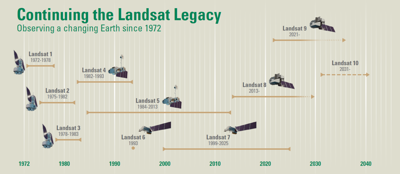
Landsat 10 Brings New Capabilities
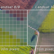
Landsat 10’s “superspectral” instrument suite features 26 spectral bands and enhanced spatial resolution, enabling more precise monitoring of water quality, agriculture, vegetation health, snow, ice, soil, and other environmental factors. These improvements provide users with greater detail in detecting and tracking environmental changes compared to previous missions.
Landsat 10 also introduces the new Worldwide Reference System (WRS-3) with 265 orbital paths, up from 233 in WRS-2.
What's NOT changing? Proven data quality excellence and data access efficiency
Landsat 10 imagery will retain these established aspects:
- Continued exemplary calibration and validation accuracy.
- Cloud-based storage, processing, and large-scale Earth observation analysis for about 900 new Level-1 products per day.
Visit the Landsat 10 webpage below to learn more about the next mission in the Landsat program.
-
Landsat 10 Landsat 10
Landsat 10 is the next mission in the joint USGS-NASA Landsat program. Landsat 10 is expected to launch in 2031 and will continue the world’s longest space-based record of Earth’s land surface. Landsat 10 will introduce new imaging capabilities for the next generation of Earth observation.
The Landsat satellite program is a successful partnership between the USGS and NASA. As with past Landsat missions, Landsat 10 will be built and operated in the same manner.
Recently, each agency published requests for proposals for critical mission elements. the USGS released a Request for Information (RFI) for the Landsat 10 Missions Operations Center and its Flights Operations. NASA issued a draft request for proposal (DRFP) for the Landsat 10 spacecraft.
You can read more about each of these below.
-

Released: NASA Goddard Issues Draft Request for Proposal for the Landsat 10 Spacecraft Released: NASA Goddard Issues Draft Request for Proposal for the Landsat 10 Spacecraft
The Landsat 10 Spacecraft Draft Request for Proposal (DRFP) is available for review via SAM.gov as of May 18, 2026. This solicitation marks a major milestone in continuing the decades-long partnership between NASA and the U.S. Geological Survey (USGS) to acquire, archive, and distribute multispectral imagery of Earth’s global landmasses and coastal regions.
-

USGS Seeks Industry Input on Landsat 10 Mission Operations Center and Flight Operations USGS Seeks Industry Input on Landsat 10 Mission Operations Center and Flight Operations
The U.S. Geological Survey (USGS) has released a Request for Information (RFI) seeking industry input on the future Landsat 10 Mission Operations Center (MOC) and flight operations architecture. The RFI, released May 7, 2026, supports planning for the next generation of Landsat ground system operations and long-term mission support.
2025 Pecora Award Recipients

NASA researchers James Irons and Eric Vermote have been selected as winners of the 2025 William T. Pecora Award for their outstanding leadership and pioneering research that revolutionized the Landsat program and advanced global, land-change monitoring.
James Irons, an emeritus scientist at NASA Goddard Space Flight Center, has devoted his career to understanding how Earth’s systems work together and to advancing remote sensing to expand that knowledge. He is best known for his contributions to the Landsat program and his belief that long-term, consistent records are important for studying changes on Earth.
Eric Vermote, a research physical scientist with NASA, is recognized for his outstanding contributions to improving the quality and reliability of global Earth observation data through the development and application of atmospheric corrections over land. The methods and algorithms he developed are critical for accounting for atmospheric effects on satellite measurements, advancing Earth observations to support a wide range of science applications.
Visit this USGS News article to learn more about their work to support Earth observation studies.
Landsat Science Team meets for first in-person meeting
When the 2026-2030 Landsat Science Team met recently, attendees were briefed on USGS and NASA expectations and priorities for the team. They also learned about current key Landsat activities, and had the opportunity to present their research and how it applies to Landsat and helps the team be successful.
Visit the webpage below to learn more about the topics discussed during the three day meeting.
-

Landsat Science Team Meeting — May 5-7, 2026 Landsat Science Team Meeting — May 5-7, 2026
The 2026-2030 Landsat Science Team met May 5-7, 2026 at the USGS Earth Resources Observation and Science (EROS) Center for their first in-person meeting.
Got Questions? We’ve Got Answers!
-

Connect Connect
Explore the Landsat social media channels, discover the latest news and resources, and find answers to your questions about Landsat Missions, science products, and data access. We are here to help you stay informed!
-

Landsat Frequently Asked Questions Landsat Frequently Asked Questions
This page lists commonly asked questions pertaining to the Landsat satellite missions, the science behind maintaining high quality Landsat data, and what products are available - and how to download them.
-

Landsat Glossary and Acronyms Landsat Glossary and Acronyms
The Landsat project uses many technical terms and acronyms to describe the satellite systems, sensors, and data formats. This information is vital for interpreting satellite imagery and using Landsat data in research and environmental monitoring. Access this information to locate the terms to learn more!
-

EROS User Services
Your trusted resource for USGS EROS data and tools. As the primary contact point for the USGS Earth Resources Observation and Science (EROS) center, we help thousands of users each year access and understand our vast archive of remotely sensed imagery and science products. From technical assistance and tool support, to training and outreach, our team ensures you have the resources you need to make...
Stay informed with the Latest in Landsat Newsletter
Direct to your inbox! Landsat's monthly newsletter features current news, uses, tools, and announcements about America's Earth-observing satellite program.
-

Latest in Landsat Newsletter Latest in Landsat Newsletter
Learn about the Latest in Landsat! This monthly newsletter highlights current news, uses, tools, and announcements about the Landsat suite of Earth-observing satellites and the data collected from them.