
Latest in Landsat March 2025 - Vol. 4 | Issue 2
Winter's Beauty Captured, Courtesy of Landsat Satellites
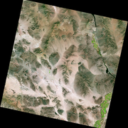
The Operational Land Imager onboard both the Landsat 8 and Landsat 9 satellites captured imagery in late January that contributed to this picturesque view of Fort Peck Lake, a sprawling reservoir formed by the Fort Peck Dam on the Missouri River in eastern Montana. Fort Peck Lake is the fifth largest reservoir in the United States, and has over 1,500 miles (2,415 kilometers) of shoreline — a distance that exceeds the length of California’s coastline.
The winter season transforms the area into a landscape of ice and snow. Click on the image to read more about the area.

Want to be a Landsat Influencer?
The USGS, in partnership with NASA, invites civil employees of U.S. Federal agencies and international partner organizations to apply for the next Landsat Science Team, serving a five-year term from 2025 to 2030.
-
Deadline Extended to March 14 – Landsat Science Team Opportunity for Federal and International Partners Deadline Extended to March 14 – Landsat Science Team Opportunity for Federal and International Partners
The USGS, in partnership with NASA, invites civil employees of U.S. Federal agencies and international partner organizations to apply for the next Landsat Science Team, serving a five-year term from 2025 to 2030.
Know a peer or team with award-winning contributions to the industry?
Dr. William T. Pecora was a motivating force behind the establishment of a program for civil remote sensing of the Earth from space. His early vision and support helped establish what we know today as the Landsat satellite program. Nominations for the 2025 award will be accepted until May 30, 2025.
Read the following article to learn more about the award nomination process.
-

2025 William T. Pecora Award Nominations Now Being Accepted 2025 William T. Pecora Award Nominations Now Being Accepted
The William T. Pecora Award is presented annually to individuals or teams using satellite or aerial remote sensing that make outstanding contributions toward understanding the Earth (land, oceans, and air), educating the next generation of scientists, informing decision-makers, or supporting natural or human-induced disaster response. Both national and international nominations are welcome.
USGS Iceberg Video Goes Viral

In February, a USGS EROS Image of the Week video featured movement of Iceberg A23a — a trillion-ton giant, larger than the state of Rhode Island — and its recent drift north towards land.
After breaking off from Antarctica’s Filchner Ice Shelf over 38 years ago, Landsat has helped keep an eye on it. While drifting through the Southern Ocean, this iceberg has had stops and starts and even tangled with a swirling ocean vortex.
At the time of this video, just last month, the iceberg was on course to collide with a small island in the South Atlantic Ocean.
The Image of the Week Massive Iceberg on the Loose quickly became popular on various outlets including social media and the USGS YouTube channel.
Get the full story by clicking on the video image!
Additional News & Webpage Updates
-

California Woodland and Forest Change California Woodland and Forest Change
The U.S. Geological Survey’s land cover products can be used to monitor changes in forests and woodlands over time. One clear example is in California, where various environmental factors have contributed to significant changes in tree cover over the past few decades. Long-term droughts, extreme heat events and severe wildfires are occurring with greater frequency in California (Westerling 2016).
-
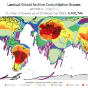
Landsat Global Archive Consolidation Landsat Global Archive Consolidation
Landsat satellites have acquired data from across the globe for nearly five decades. The National Satellite Land Remote Sensing Data Archive at the U.S. Geological Survey (USGS) Earth Resources Observation and Science (EROS) Center holds the single most geographically and temporally rich collection of Landsat data in the world.
Landsat Products Support Efforts to Restore Chesapeake Bay

The Chesapeake Bay is the largest estuary in the United States. Located in the Mid-Atlantic region of the East Coast, it runs north-south from the mouth of the Susquehanna River near Havre de Grace, Maryland, to the Atlantic Ocean near Virginia Beach, Virginia. While just two states—Maryland and Virginia—border the Chesapeake Bay, its enormous watershed covers parts of six states and the District of Columbia. Fed by numerous rivers and streams, its brackish waters provide habitat for an array of wildlife species.
As one of the most productive regions in the United States, the Chesapeake Bay is a highly valued ecological, economic, and recreational resource. Yet, pollution poses a significant threat to the health of the estuary. Chemical contaminants, industrial discharge, urban stormwater, and agricultural runoff have led to declines in water quality and biodiversity.
Fortunately, efforts are underway to restore the Chesapeake Bay through collaborative initiatives that are focused on reducing pollution and protecting vital habitats. The data collected by the sensors onboard Landsat satellites are meticulously processed into high level science products, each offering an important means of helping scientists and land managers monitor the health of the Chesapeake Bay and its watershed.
Including this Level-1 image, check out the water-related and land cover products displayed below.

Landsat Level-3 Dynamic Surface Water Extent of the Chesapeake Bay
The Chesapeake Bay is roughly 200 miles (322 kilometers) in length and varies in width from a mere 4 miles (6.4 kilometers) near Aberdeen, Maryland, to 30 miles (48 kilometers) near Cape Charles, Virginia. The immense body of water has an average depth of 21 feet (6.4 meters), but it dips down to 174 feet (53 meters) at its deepest location near Bloody Point on Kent Island, Maryland. Fed by…

Annual NLCD for the Chesapeake Bay Region
The Chesapeake Bay watershed has experienced substantial population growth over the last several decades. Since 1950, the population has more than doubled, and between 1980 and 2023, the number increased from 12.7 million to 18.6 million. This increase in population has led to more urban development and changes to forest, agricultural, and wetland cover, which has ultimately impacted the…

Landsat Level-2 Provisional Aquatic Reflectance of the Chesapeake Bay
The Chesapeake Bay watershed spans more than 64,000 square miles (166,000 square kilometers) and encompasses parts of six states—Delaware, Maryland, New York, Pennsylvania, Virginia, and West Virginia—and the District of Columbia. It is home to more than 18 million people, with roughly 10 million of those people living along or near the shores of the Chesapeake Bay. Population and industrial…
Do you have questions about Landsat? Check these pages to learn more!
-

Landsat Frequently Asked Questions Landsat Frequently Asked Questions
This page lists commonly asked questions pertaining to the Landsat satellite missions, the science behind maintaining high quality Landsat data, and what products are available - and how to download them.
-

Connect Connect
Explore the Landsat social media channels, discover the latest news and resources, and find answers to your questions about Landsat Missions, science products, and data access. We are here to help you stay informed!

Landsat is a joint effort of the U.S. Geological Survey (USGS) and the National Aeronautics and Space Administration (NASA). This partnership creates an unprecedented continuous record of natural and human-induced changes on the global landscape.