
Latest in Landsat May 2026 - Vol. 5 | Issue 5
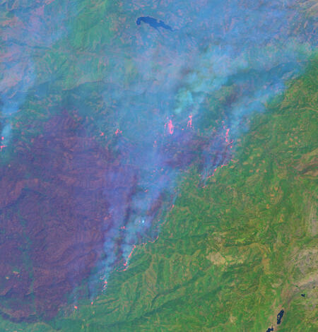
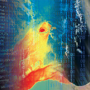
Landsat Exposes Fires at Night
Check out the article below to learn how
-

Nighttime Imaging Grows Landsat’s Science Value Nighttime Imaging Grows Landsat’s Science Value
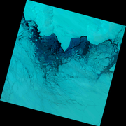
For more than 50 years, Landsat has imaged Earth’s land and near-shore surfaces as the satellites descend in midmorning orbit, when daily sunlight is optimal. That’s just what they’ve always done. Currently, Landsat 8 and Landsat 9 circle the globe while also making better use of their ascending paths, peering into the darkness for special requests.
Landsat Product Processing Update
-
Landsat 9 Products Impacted by 2025 Safehold Now Available Landsat 9 Products Impacted by 2025 Safehold Now Available
Landsat 9 data acquired following an October 2025 safehold event were recently processed into Landsat Level-1 and Level-2 products for the first time and are now available for download. Additionally, a small number of Landsat products processed just prior and just after the safehold were also reprocessed.
Nomination Deadline extended to June 5, 2026
-

2026 William T. Pecora Award Nominations Being Accepted 2026 William T. Pecora Award Nominations Being Accepted
The William T. Pecora Award is presented annually to individuals or teams using satellite or aerial remote sensing that make outstanding contributions toward understanding the Earth (land, oceans, and air), educating the next generation of scientists, informing decision-makers, or supporting natural or human-induced disaster response. Both national and international nominations are welcome.
Visit These Helpful Resources
Landsat Citations
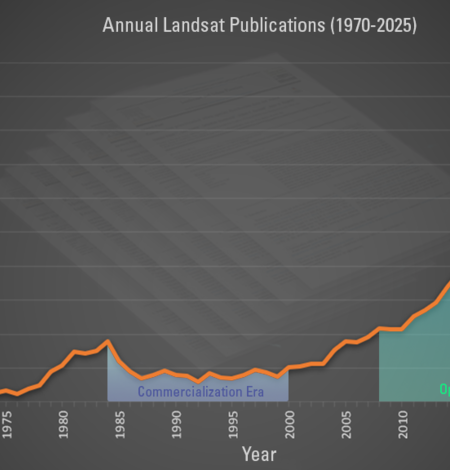
This graphic displays the number of Landsat-related publications starting in 1970. While publications decreased during the Commercialization Era, research rebounded greatly after the USGS open data policy decision in 2008.
Data
The USGS EROS Center is home to a vast collection of remotely sensed data of Earth, including Landsat imagery, aerial photos, and science products. EROS also hosts the Land Processes Distributed Active Archive Center (LP DAAC), which distributes global land surface data from NASA satellite missions. Use the links below to explore products, access data, and view notifications.

Landsat Interactives
These webpages use maps, images, and stories to show how Landsat satellites help people around the world. They highlight real examples—like tracking city growth, supporting farmers, managing water, and responding to natural disasters—making it easy to see how Landsat data benefits everyday life.
Got Questions? We’ve Got Answers!
-

Connect Connect
Access the information on this page to learn more about Landsat, access our social media platforms, or contact us with questions you have about the Landsat missions, the available science products, and how to access Landsat data!
-

Landsat Frequently Asked Questions Landsat Frequently Asked Questions
This page lists commonly asked questions pertaining to the Landsat satellite missions, the science behind maintaining high quality Landsat data, and what products are available - and how to download them.
-
Landsat Glossary and Acronyms Landsat Glossary and Acronyms
The Landsat project uses many technical terms and acronyms to describe the satellite systems, sensors, and data formats. This information is vital for interpreting satellite imagery and using Landsat data in research and environmental monitoring. Access this information to locate the terms to learn more!
-
EROS User Services
Your trusted resource for USGS EROS data and tools. As the primary contact point for the USGS Earth Resources Observation and Science (EROS) center, we help thousands of users each year access and understand our vast archive of remotely sensed imagery and science products. From technical assistance and tool support, to training and outreach, our team ensures you have the resources you need to make...
Be Social with Us!
-

Social Media Social Media
Check out the Landsat Missions social media accounts and tap the FOLLOW button to stay in-the-know when it comes to all things Landsat!
Stay informed with the Latest in Landsat Newsletter
Direct to your inbox! Landsat's monthly newsletter features current news, uses, tools, and announcements about America's Earth-observing satellite program.
-

Latest in Landsat Newsletter Latest in Landsat Newsletter
Learn about the Latest in Landsat! This monthly newsletter highlights current news, uses, tools, and announcements about the Landsat suite of Earth-observing satellites and the data collected from them.