
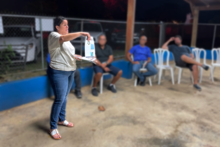
Legna Torres-García engages with stakeholders in Puerto Rico

Detailed Description
Dr. Legna Torres-García of the St. Petersburg Coastal and Marine Science Center is leading an effort to build relationships with stakeholders on the island of Puerto Rico to better understand their needs for natural hazards data and resources and share information available from USGS that are relevant to the island. Here, Legna discusses USGS coastal hazards research with the Professional Fishermen's Association.
Sources/Usage
Public Domain.
Related

Puerto Rico Natural Hazards: Coastal | Peligros naturales de Puerto Rico: Costas
This page is a collection of USGS coastal hazard research in Puerto Rico, including shoreline changes, coral reef assessments, and coastal flooding. A brief description of highlighted projects can be found below. All coastal hazard publications, data releases, and news for Puerto Rico can be accessed on this page. Esta página es una recopilación de investigaciones del USGS sobre los riesgos...

Operational Total Water Level and Coastal Change Forecasts
The viewer shows predictions of the timing and magnitude of water levels at the shoreline and potential impacts to coastal dunes.
Related
Puerto Rico Natural Hazards: Coastal | Peligros naturales de Puerto Rico: Costas
This page is a collection of USGS coastal hazard research in Puerto Rico, including shoreline changes, coral reef assessments, and coastal flooding. A brief description of highlighted projects can be found below. All coastal hazard publications, data releases, and news for Puerto Rico can be accessed on this page. Esta página es una recopilación de investigaciones del USGS sobre los riesgos...
Operational Total Water Level and Coastal Change Forecasts
The viewer shows predictions of the timing and magnitude of water levels at the shoreline and potential impacts to coastal dunes.