
La isla de Puerto Rico está sujeta a numerosos peligros naturales, incluyendo huracanes y erosión costera. La información sobre cómo responden los entornos costeros de la isla a estos eventos es fundamental para reforzar la resiliencia costera. La Dra.
Puerto Rico Natural Hazards: Coastal | Peligros naturales de Puerto Rico: Costas
Active
By Natural Hazards Mission Area
June 22, 2022
Real-time Camera and Waves, Wind, and Water Level Data Available in Dorado and Isla Verde
Cámara en tiempo real y datos de olas, viento y nivel de agua disponibles en Dorado e Isla Verde
Cámara en tiempo real y datos de olas, viento y nivel de agua disponibles en Dorado e Isla Verde
Assessment of Hurricane-induced Coastal Erosion Hazards in Puerto Rico
Evaluación de los peligros de erosión costera inducidos por Huracanes en Puerto Rico
Evaluación de los peligros de erosión costera inducidos por Huracanes en Puerto Rico
Shoreline Changes in Puerto Rico
Cambios Costeros en Puerto Rico
Cambios Costeros en Puerto Rico
Benefits of coral reef restoration
Los beneficios de la restauración de los arrecifes de coral
Los beneficios de la restauración de los arrecifes de coral
Using Video Imagery to Study Wave Dynamics in Tres Palmas
Utilizando imágenes de video para estudiar la dinámica de las olas en Tres Palmas
Utilizando imágenes de video para estudiar la dinámica de las olas en Tres Palmas
This page is a collection of USGS coastal hazard research in Puerto Rico, including shoreline changes, coral reef assessments, and coastal flooding. A brief description of highlighted projects can be found below. All coastal hazard publications, data releases, and news for Puerto Rico can be accessed on this page.
Esta página es una recopilación de investigaciones del USGS sobre los riesgos costeros en Puerto Rico que incluye los cambios en el litoral, las evaluaciones de los arrecifes de coral y las inundaciones costeras. A continuación, podrá encontrar una breve descripción de algunos proyectos destacados. Todas las publicaciones, cesiones de datos y noticias sobre los riesgos costeros en Puerto Rico están disponibles en esta página.
Shorelines | Las líneas de costa
Media

Sources/Usage: Public Domain. View Media Details
Figura 1: Líneas de costa históricas de Puerto Rico, disponibles en el Portal de Riesgos por Cambios Costeros del USGS.
Historical shoreline positions were determined for Puerto Rico from 1901 to 2018, using historical maps, aerial photographs, high resolution satellite imagery, and lidar (Light Detection and Ranging) data. Rates of change were measured with the Digital Shoreline Analysis System (DSAS), which calculates statistics from multiple historical shoreline positions. The goal of this project was to develop the existing USGS shoreline database in Puerto Rico. Data are available to download in the USGS Coastal Change Hazards Portal.
Las posiciones históricas de las líneas de costa fueron determinadas para Puerto Rico entre 1901 y 2018 usando mapas históricos, fotografías aéreas, imágenes satelitales de alta resolución y datos de lidar (detección de luz y alcance). Los rangos de cambio se midieron con el Sistema de Análisis Digital de la Costa (DSAS, por sus siglas en inglés), que calcula las estadísticas de distintas posiciones históricas de la costa. El objetivo de este proyecto era desarrollar la base de datos actual del USGS en las costas de Puerto Rico. Se puede descargar la información en el Portal de Riesgos por Cambios Costeros del USGS (Coastal Change Hazards Portal).
Coral Reef Assessments | Las evaluaciones de los arrecifes de coral
Media

Sources/Usage: Public Domain. View Media Details
Figura 2: Arrecife de coral en La Parguera, Lajas, Puerto Rico.
USGS has a published a variety of research regarding coral reefs in Puerto Rico, covering topics such as the value reefs for flood risk reduction, a comparison of pre-storm and post-storm flood levels, hurricane impacts on coral reefs, and possible benefits of coral reef restoration scenarios to mitigate coastal hazards. Summary reports can be accessed in the links below:
El USGS ha publicado una variedad de investigaciones con relación a los arrecifes de coral en Puerto Rico que abarcan temas como la importancia de los arrecifes para la reducción de los riesgos de inundación, una comparación de los niveles de inundación antes y después de una tormenta, el impacto de los huracanes en los arrecifes de coral y los posibles beneficios de la restauración de arrecifes para mitigar los peligros costeros. Los siguientes enlaces contienen resúmenes de los informes realizados:
-
The value of US coral reefs for risk reduction - Puerto Rico | El valor de los arrecifes de coral en los Estados Unidos para la reducción de riesgos - Puerto Rico
-
Hurricanes increase future flood risk in Puerto Rico and Florida | Huracanes aumentan el riesgo de inundaciones futuras de Puerto Rico y Florida
-
Impact of damage by hurricanes Irma and Maria in Puerto Rico | Impacto de los daños causados por los huracanes Irma y María en Puerto Rico
-
Social and economic benefits of coral reef restoration: Puerto Rico | Beneficios sociales y económicos de la restauración de los arrecifes de coral: Puerto Rico
-
Potential annual coastal hazard risk decrease: Puerto Rico | Disminución potencial anual del riesgo de peligros costeros: Puerto Rico
Media

Sources/Usage: Public Domain. View Media Details
Figura 3: Erosión costera en Cabo Rojo, Puerto Rico.
Dune Impact Probabilities | Las probabilidades del impacto de las dunas
Another ongoing project is focusing on estimating projections of wave impacts on sand dunes to determine the probability that waves will erode, overtop, or completely inundate dunes for generalized category 1-5 hurricane conditions. This approach is also called probability of Collision, Overwash, and Inundation (pCOI). Coastal features were extracted from lidar information. Results will be available for Puerto Rico in the USGS Coastal Change Hazards Portal.
Otro proyecto actual se centra en estimar las proyecciones del impacto de las olas en las dunas de arena para determinar la probabilidad de Colisión con la duna, Desborde sobre la duna e Inundación de la duna (pCOI, por sus siglas en inglés) a fin de evaluar las probabilidades de que las olas produzcan erosión, sobrepasen o inunden por completo las dunas en el caso de los huracanes de categoría de 1 a 5. Las características de las costas se extrajeron de la información del lidar. Los resultados para Puerto Rico estarán disponibles en el Portal de Cambios Costeros del USGS (USGS Coastal Change Hazards Portal).
Media
Sources/Usage: Public Domain. View Media Details
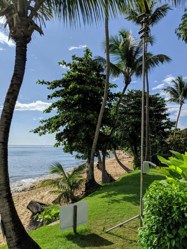
Figura 4: Varias cámaras de video observan la costa y el arrecife de coral en Tres Palmas en Rincón, en la costa oeste de Puerto Rico.
Wave Dynamics | La dinámica de las olas
In Isla Verde, San Juan, and Tres Palmas, Rincón, USGS researchers have installed camera systems to measure where waves break across the reef and the extent of wave runup on the shore to improve our understanding of coastal flooding. Current work includes expanding this project to other regions in Puerto Rico.
En Isla Verde, San Juan y Tres Palmas, Rincón, algunos investigadores del USGS han instalado sistemas de cámaras para medir en qué parte del arrecife rompen las olas y la extensión del remonte de las olas (wave runup) sobre la costa a fin de profundizar nuestra comprensión sobre inundaciones costeras. Actualmente, estamos trabajando para expandir este proyecto a otras regiones de Puerto Rico.
Learn more about USGS Puerto Rico hazards research and tools. | Obtenga más información sobre las herramientas e investigaciones del USGS acerca de riegros en Puerto Rico.
Science
Science
USGS scientists and staff study resources and processes from shorelines and estuaries to the continental shelf and deep sea. Coastal research projects in Puerto Rico have focused on shoreline change, coral reefs, and hurricane impacts. Learn more about these projects in the links below.
Ciencias
Ciencias
Los científicos y personal del USGS estudian los recursos y procesos desde las costas y estuarios hasta la plataforma continental y las aguas profundas. Los proyectos de investigación costera de Puerto Rico se han centrado en los cambios del litoral, los arrecifes de coral y el impacto de los huracanes. Conozca más sobre estos proyectos en los siguientes enlaces.

Digital Shoreline Analysis System (DSAS)
Software for calculating positional boundary change over time The Digital Shoreline Analysis System (DSAS) version 6 is a standalone application that calculates shoreline or boundary change over time. The GIS of a user’s choice is used to prepare the data for DSAS. Like previous versions, DSAS v.6 enables a user to calculate rate-of-change statistics from multiple historical shoreline positions...

Using Video Imagery to Study Wave Dynamics: Tres Palmas
To study wave dynamics along an active coastline, video cameras were installed on the west coast of Puerto Rico at Tres Palmas in Rincón.

Quantifying Flood Risk and Reef Risk Reduction Benefits in Florida and Puerto Rico: The Consequences of Hurricane Damage, Long-term Degradation, and Restoration Opportunities
Coastal flooding and erosion from extreme weather events affect thousands of vulnerable coastal communities; the impacts of coastal flooding are predicted to worsen during this century because of population growth and climate change. Hurricanes Irma and Maria in 2017 were particularly devasting to humans and natural communities. The coral reefs off the State of Florida and the Commonwealth of...
Coral Reef Project: Puerto Rico
To better understand how waves move across coral reefs and cause flooding on tropical shorelines, USGS scientists have installed video cameras and oceanographic instruments off San Juan and Rincón, Puerto Rico. Their work is part of a study funded by USGS after Hurricanes Irma and María. The offshore instruments measure wave heights and speeds; the onshore video cameras show where waves break on...

Using Video Imagery to Study Wave Dynamics: Isla Verde
USGS scientists installed video cameras atop a building and oceanographic instruments off San Juan, Puerto Rico, to better understand how waves move across coral reefs and cause flooding on tropical shorelines.
Explore USGS media products for Puerto Rico about coastal hazards.
Explore los productos multimedia del USGS para Puerto Rico sobre riesgos costeros.

Peligros Costeros de Puerto Rico
La isla de Puerto Rico está sujeta a numerosos peligros naturales, incluyendo huracanes y erosión costera. La información sobre cómo responden los entornos costeros de la isla a estos eventos es fundamental para reforzar la resiliencia costera. La Dra.
Puerto Rico Coastal Hazards
The island of Puerto Rico is subject to numerous natural hazards including hurricanes and coastal erosion. Information on how the island’s coastal environments respond to these events is critical for bolstering coastal resilience. Dr.
The island of Puerto Rico is subject to numerous natural hazards including hurricanes and coastal erosion. Information on how the island’s coastal environments respond to these events is critical for bolstering coastal resilience. Dr.

Hurricanes increase future flood risk in Puerto Rico and Florida, 1
Hurricanes increase future flood risk in Puerto Rico and Florida, 1Report Summary
Hurricane Damage to Coral Reefs in 2017 Increases Future Flood Risk in Puerto Rico and Florida
The damage to reef natural infrastructure from Hurricanes Irma and Maria puts U.S. people and property at significant risk of future flooding
Key Points

Hurricanes increase future flood risk in Puerto Rico and Florida, 2
Hurricanes increase future flood risk in Puerto Rico and Florida, 2The significant flood risk consequences of damage to coral reefs from Hurricanes Irma and Maria clarify why the defense benefits from this natural infrastructure should be recovered, repaired and restored.

Impact of damage by hurricanes Irma and Maria in Puerto Rico
Impact of damage by hurricanes Irma and Maria in Puerto RicoMaps of Puerto Rico show the increase in annual coastal hazard risk due to damage by Hurricanes Irma and Maria.
- Increase in population at risk due to coral reef damage per kilometer (top)
- Increase in value ($) of assets at risk due to coral reef damage per kilometer (bottom)
Potential annual coastal hazard risk decrease: Puerto Rico
Potential annual coastal hazard risk decrease: Puerto RicoMaps show the potential decrease in annual coastal hazard risk provided by coral reef restoration in Puerto Rico.
Potential annual coastal hazard risk decrease: Puerto Rico
Potential annual coastal hazard risk decrease: Puerto RicoMaps show the potential decrease in annual coastal hazard risk provided by coral reef restoration in Puerto Rico.

Social and economic benefits of coral reef restoration: Puerto Rico 1
Social and economic benefits of coral reef restoration: Puerto Rico 1Report Summary
The Social and Economic Benefits of Coral Reef Restoration in Puerto Rico
Key Points
Social and economic benefits of coral reef restoration: Puerto Rico 1
Social and economic benefits of coral reef restoration: Puerto Rico 1Report Summary
The Social and Economic Benefits of Coral Reef Restoration in Puerto Rico
Key Points

Social and economic benefits of coral reef restoration: Puerto Rico 2
Social and economic benefits of coral reef restoration: Puerto Rico 2Coral reef restoration can yield significant flood reduction benefits. These natural defenses were damaged in the 2017 hurricanes; their recovery would reduce the risks of further storm damages to nature, people and property.

Beneficios sociales y económicos de la restauración: Puerto Rico 1
Beneficios sociales y económicos de la restauración: Puerto Rico 1RESUMEN DEL REPORTE
Los beneficios sociales y económicos de la restauración de arrecifes de coral en Puerto Rico
PUNTOS CLAVE
Beneficios sociales y económicos de la restauración: Puerto Rico 1
Beneficios sociales y económicos de la restauración: Puerto Rico 1RESUMEN DEL REPORTE
Los beneficios sociales y económicos de la restauración de arrecifes de coral en Puerto Rico
PUNTOS CLAVE

Beneficios sociales y económicos de la restauración: Puerto Rico 2
Beneficios sociales y económicos de la restauración: Puerto Rico 2La restauración de los arrecifes de coral puede producir beneficios significativos en la reducción de inundaciones. Estas defensas naturales sufrieron daños a causa de los huracanes de 2017; su recuperación reduciría riesgos adicionales a la naturaleza, las personas y propiedades causados por tormentas.

Huracanes aumentan el riesgo de inundaciones futuras en Puerto Rico, 1
Huracanes aumentan el riesgo de inundaciones futuras en Puerto Rico, 1RESUMEN DEL REPORTE
Los daños causados por los huracanes a los arrecifes de coral en 2017 aumentan el riesgo de inundaciones futuras en Puerto Rico y Florida
Huracanes aumentan el riesgo de inundaciones futuras en Puerto Rico, 1
Huracanes aumentan el riesgo de inundaciones futuras en Puerto Rico, 1RESUMEN DEL REPORTE
Los daños causados por los huracanes a los arrecifes de coral en 2017 aumentan el riesgo de inundaciones futuras en Puerto Rico y Florida

Huracanes aumentan el riesgo de inundaciones futuras en Puerto Rico, 2
Huracanes aumentan el riesgo de inundaciones futuras en Puerto Rico, 2Las consecuencias significativas del riesgo de inundación debido a los daños en los arrecifes de coral causado por los huracanes Irma y María clarifican por qué los beneficios de defensa de esta infraestructura natural deben recuperarse, repararse y restaurarse.

Shaded relief and combined bathymetry map of Puerto Rico
Shaded relief and combined bathymetry map of Puerto Rico(Top image) Shaded relief of the new multibeam bathymetry along the Puerto Rico Trench illuminated from the northwest. Thin contours indicate bathymetry at 500-m intervals. (Bottom image) Combined bathymetry map of the multibeam bathymetry data, single-beam bathymetry compilation around Puerto Rico, Lidar data near shore, and topography of Puerto Rico.
This page is a collection of USGS coastal hazard research in Puerto Rico, including shoreline changes, coral reef assessments, and coastal flooding. A brief description of highlighted projects can be found below. All coastal hazard publications, data releases, and news for Puerto Rico can be accessed on this page.
Esta página es una recopilación de investigaciones del USGS sobre los riesgos costeros en Puerto Rico que incluye los cambios en el litoral, las evaluaciones de los arrecifes de coral y las inundaciones costeras. A continuación, podrá encontrar una breve descripción de algunos proyectos destacados. Todas las publicaciones, cesiones de datos y noticias sobre los riesgos costeros en Puerto Rico están disponibles en esta página.
Shorelines | Las líneas de costa
Media
Sources/Usage: Public Domain. View Media Details
Figura 1: Líneas de costa históricas de Puerto Rico, disponibles en el Portal de Riesgos por Cambios Costeros del USGS.
Historical shoreline positions were determined for Puerto Rico from 1901 to 2018, using historical maps, aerial photographs, high resolution satellite imagery, and lidar (Light Detection and Ranging) data. Rates of change were measured with the Digital Shoreline Analysis System (DSAS), which calculates statistics from multiple historical shoreline positions. The goal of this project was to develop the existing USGS shoreline database in Puerto Rico. Data are available to download in the USGS Coastal Change Hazards Portal.
Las posiciones históricas de las líneas de costa fueron determinadas para Puerto Rico entre 1901 y 2018 usando mapas históricos, fotografías aéreas, imágenes satelitales de alta resolución y datos de lidar (detección de luz y alcance). Los rangos de cambio se midieron con el Sistema de Análisis Digital de la Costa (DSAS, por sus siglas en inglés), que calcula las estadísticas de distintas posiciones históricas de la costa. El objetivo de este proyecto era desarrollar la base de datos actual del USGS en las costas de Puerto Rico. Se puede descargar la información en el Portal de Riesgos por Cambios Costeros del USGS (Coastal Change Hazards Portal).
Coral Reef Assessments | Las evaluaciones de los arrecifes de coral
Media
Sources/Usage: Public Domain. View Media Details
Figura 2: Arrecife de coral en La Parguera, Lajas, Puerto Rico.
USGS has a published a variety of research regarding coral reefs in Puerto Rico, covering topics such as the value reefs for flood risk reduction, a comparison of pre-storm and post-storm flood levels, hurricane impacts on coral reefs, and possible benefits of coral reef restoration scenarios to mitigate coastal hazards. Summary reports can be accessed in the links below:
El USGS ha publicado una variedad de investigaciones con relación a los arrecifes de coral en Puerto Rico que abarcan temas como la importancia de los arrecifes para la reducción de los riesgos de inundación, una comparación de los niveles de inundación antes y después de una tormenta, el impacto de los huracanes en los arrecifes de coral y los posibles beneficios de la restauración de arrecifes para mitigar los peligros costeros. Los siguientes enlaces contienen resúmenes de los informes realizados:
-
The value of US coral reefs for risk reduction - Puerto Rico | El valor de los arrecifes de coral en los Estados Unidos para la reducción de riesgos - Puerto Rico
-
Hurricanes increase future flood risk in Puerto Rico and Florida | Huracanes aumentan el riesgo de inundaciones futuras de Puerto Rico y Florida
-
Impact of damage by hurricanes Irma and Maria in Puerto Rico | Impacto de los daños causados por los huracanes Irma y María en Puerto Rico
-
Social and economic benefits of coral reef restoration: Puerto Rico | Beneficios sociales y económicos de la restauración de los arrecifes de coral: Puerto Rico
-
Potential annual coastal hazard risk decrease: Puerto Rico | Disminución potencial anual del riesgo de peligros costeros: Puerto Rico
Media
Sources/Usage: Public Domain. View Media Details
Figura 3: Erosión costera en Cabo Rojo, Puerto Rico.
Dune Impact Probabilities | Las probabilidades del impacto de las dunas
Another ongoing project is focusing on estimating projections of wave impacts on sand dunes to determine the probability that waves will erode, overtop, or completely inundate dunes for generalized category 1-5 hurricane conditions. This approach is also called probability of Collision, Overwash, and Inundation (pCOI). Coastal features were extracted from lidar information. Results will be available for Puerto Rico in the USGS Coastal Change Hazards Portal.
Otro proyecto actual se centra en estimar las proyecciones del impacto de las olas en las dunas de arena para determinar la probabilidad de Colisión con la duna, Desborde sobre la duna e Inundación de la duna (pCOI, por sus siglas en inglés) a fin de evaluar las probabilidades de que las olas produzcan erosión, sobrepasen o inunden por completo las dunas en el caso de los huracanes de categoría de 1 a 5. Las características de las costas se extrajeron de la información del lidar. Los resultados para Puerto Rico estarán disponibles en el Portal de Cambios Costeros del USGS (USGS Coastal Change Hazards Portal).
Media
Sources/Usage: Public Domain. View Media Details
Figura 4: Varias cámaras de video observan la costa y el arrecife de coral en Tres Palmas en Rincón, en la costa oeste de Puerto Rico.
Wave Dynamics | La dinámica de las olas
In Isla Verde, San Juan, and Tres Palmas, Rincón, USGS researchers have installed camera systems to measure where waves break across the reef and the extent of wave runup on the shore to improve our understanding of coastal flooding. Current work includes expanding this project to other regions in Puerto Rico.
En Isla Verde, San Juan y Tres Palmas, Rincón, algunos investigadores del USGS han instalado sistemas de cámaras para medir en qué parte del arrecife rompen las olas y la extensión del remonte de las olas (wave runup) sobre la costa a fin de profundizar nuestra comprensión sobre inundaciones costeras. Actualmente, estamos trabajando para expandir este proyecto a otras regiones de Puerto Rico.
Learn more about USGS Puerto Rico hazards research and tools. | Obtenga más información sobre las herramientas e investigaciones del USGS acerca de riegros en Puerto Rico.
Science
Science
USGS scientists and staff study resources and processes from shorelines and estuaries to the continental shelf and deep sea. Coastal research projects in Puerto Rico have focused on shoreline change, coral reefs, and hurricane impacts. Learn more about these projects in the links below.
Ciencias
Ciencias
Los científicos y personal del USGS estudian los recursos y procesos desde las costas y estuarios hasta la plataforma continental y las aguas profundas. Los proyectos de investigación costera de Puerto Rico se han centrado en los cambios del litoral, los arrecifes de coral y el impacto de los huracanes. Conozca más sobre estos proyectos en los siguientes enlaces.
Digital Shoreline Analysis System (DSAS)
Software for calculating positional boundary change over time The Digital Shoreline Analysis System (DSAS) version 6 is a standalone application that calculates shoreline or boundary change over time. The GIS of a user’s choice is used to prepare the data for DSAS. Like previous versions, DSAS v.6 enables a user to calculate rate-of-change statistics from multiple historical shoreline positions...
Using Video Imagery to Study Wave Dynamics: Tres Palmas
To study wave dynamics along an active coastline, video cameras were installed on the west coast of Puerto Rico at Tres Palmas in Rincón.
Quantifying Flood Risk and Reef Risk Reduction Benefits in Florida and Puerto Rico: The Consequences of Hurricane Damage, Long-term Degradation, and Restoration Opportunities
Coastal flooding and erosion from extreme weather events affect thousands of vulnerable coastal communities; the impacts of coastal flooding are predicted to worsen during this century because of population growth and climate change. Hurricanes Irma and Maria in 2017 were particularly devasting to humans and natural communities. The coral reefs off the State of Florida and the Commonwealth of...
Coral Reef Project: Puerto Rico
To better understand how waves move across coral reefs and cause flooding on tropical shorelines, USGS scientists have installed video cameras and oceanographic instruments off San Juan and Rincón, Puerto Rico. Their work is part of a study funded by USGS after Hurricanes Irma and María. The offshore instruments measure wave heights and speeds; the onshore video cameras show where waves break on...
Using Video Imagery to Study Wave Dynamics: Isla Verde
USGS scientists installed video cameras atop a building and oceanographic instruments off San Juan, Puerto Rico, to better understand how waves move across coral reefs and cause flooding on tropical shorelines.
Explore USGS media products for Puerto Rico about coastal hazards.
Explore los productos multimedia del USGS para Puerto Rico sobre riesgos costeros.
Peligros Costeros de Puerto Rico
La isla de Puerto Rico está sujeta a numerosos peligros naturales, incluyendo huracanes y erosión costera. La información sobre cómo responden los entornos costeros de la isla a estos eventos es fundamental para reforzar la resiliencia costera. La Dra.
La isla de Puerto Rico está sujeta a numerosos peligros naturales, incluyendo huracanes y erosión costera. La información sobre cómo responden los entornos costeros de la isla a estos eventos es fundamental para reforzar la resiliencia costera. La Dra.
Puerto Rico Coastal Hazards
The island of Puerto Rico is subject to numerous natural hazards including hurricanes and coastal erosion. Information on how the island’s coastal environments respond to these events is critical for bolstering coastal resilience. Dr.
The island of Puerto Rico is subject to numerous natural hazards including hurricanes and coastal erosion. Information on how the island’s coastal environments respond to these events is critical for bolstering coastal resilience. Dr.
Hurricanes increase future flood risk in Puerto Rico and Florida, 1
Hurricanes increase future flood risk in Puerto Rico and Florida, 1Report Summary
Hurricane Damage to Coral Reefs in 2017 Increases Future Flood Risk in Puerto Rico and Florida
The damage to reef natural infrastructure from Hurricanes Irma and Maria puts U.S. people and property at significant risk of future flooding
Key Points
Hurricanes increase future flood risk in Puerto Rico and Florida, 2
Hurricanes increase future flood risk in Puerto Rico and Florida, 2The significant flood risk consequences of damage to coral reefs from Hurricanes Irma and Maria clarify why the defense benefits from this natural infrastructure should be recovered, repaired and restored.
Impact of damage by hurricanes Irma and Maria in Puerto Rico
Impact of damage by hurricanes Irma and Maria in Puerto RicoMaps of Puerto Rico show the increase in annual coastal hazard risk due to damage by Hurricanes Irma and Maria.
- Increase in population at risk due to coral reef damage per kilometer (top)
- Increase in value ($) of assets at risk due to coral reef damage per kilometer (bottom)
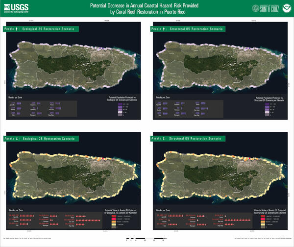
Potential annual coastal hazard risk decrease: Puerto Rico
Potential annual coastal hazard risk decrease: Puerto RicoMaps show the potential decrease in annual coastal hazard risk provided by coral reef restoration in Puerto Rico.
Potential annual coastal hazard risk decrease: Puerto Rico
Potential annual coastal hazard risk decrease: Puerto RicoMaps show the potential decrease in annual coastal hazard risk provided by coral reef restoration in Puerto Rico.
Social and economic benefits of coral reef restoration: Puerto Rico 1
Social and economic benefits of coral reef restoration: Puerto Rico 1Report Summary
The Social and Economic Benefits of Coral Reef Restoration in Puerto Rico
Key Points
Social and economic benefits of coral reef restoration: Puerto Rico 1
Social and economic benefits of coral reef restoration: Puerto Rico 1Report Summary
The Social and Economic Benefits of Coral Reef Restoration in Puerto Rico
Key Points
Social and economic benefits of coral reef restoration: Puerto Rico 2
Social and economic benefits of coral reef restoration: Puerto Rico 2Coral reef restoration can yield significant flood reduction benefits. These natural defenses were damaged in the 2017 hurricanes; their recovery would reduce the risks of further storm damages to nature, people and property.
Beneficios sociales y económicos de la restauración: Puerto Rico 1
Beneficios sociales y económicos de la restauración: Puerto Rico 1RESUMEN DEL REPORTE
Los beneficios sociales y económicos de la restauración de arrecifes de coral en Puerto Rico
PUNTOS CLAVE
Beneficios sociales y económicos de la restauración: Puerto Rico 1
Beneficios sociales y económicos de la restauración: Puerto Rico 1RESUMEN DEL REPORTE
Los beneficios sociales y económicos de la restauración de arrecifes de coral en Puerto Rico
PUNTOS CLAVE
Beneficios sociales y económicos de la restauración: Puerto Rico 2
Beneficios sociales y económicos de la restauración: Puerto Rico 2La restauración de los arrecifes de coral puede producir beneficios significativos en la reducción de inundaciones. Estas defensas naturales sufrieron daños a causa de los huracanes de 2017; su recuperación reduciría riesgos adicionales a la naturaleza, las personas y propiedades causados por tormentas.
Huracanes aumentan el riesgo de inundaciones futuras en Puerto Rico, 1
Huracanes aumentan el riesgo de inundaciones futuras en Puerto Rico, 1RESUMEN DEL REPORTE
Los daños causados por los huracanes a los arrecifes de coral en 2017 aumentan el riesgo de inundaciones futuras en Puerto Rico y Florida
Huracanes aumentan el riesgo de inundaciones futuras en Puerto Rico, 1
Huracanes aumentan el riesgo de inundaciones futuras en Puerto Rico, 1RESUMEN DEL REPORTE
Los daños causados por los huracanes a los arrecifes de coral en 2017 aumentan el riesgo de inundaciones futuras en Puerto Rico y Florida
Huracanes aumentan el riesgo de inundaciones futuras en Puerto Rico, 2
Huracanes aumentan el riesgo de inundaciones futuras en Puerto Rico, 2Las consecuencias significativas del riesgo de inundación debido a los daños en los arrecifes de coral causado por los huracanes Irma y María clarifican por qué los beneficios de defensa de esta infraestructura natural deben recuperarse, repararse y restaurarse.
Shaded relief and combined bathymetry map of Puerto Rico
Shaded relief and combined bathymetry map of Puerto Rico(Top image) Shaded relief of the new multibeam bathymetry along the Puerto Rico Trench illuminated from the northwest. Thin contours indicate bathymetry at 500-m intervals. (Bottom image) Combined bathymetry map of the multibeam bathymetry data, single-beam bathymetry compilation around Puerto Rico, Lidar data near shore, and topography of Puerto Rico.