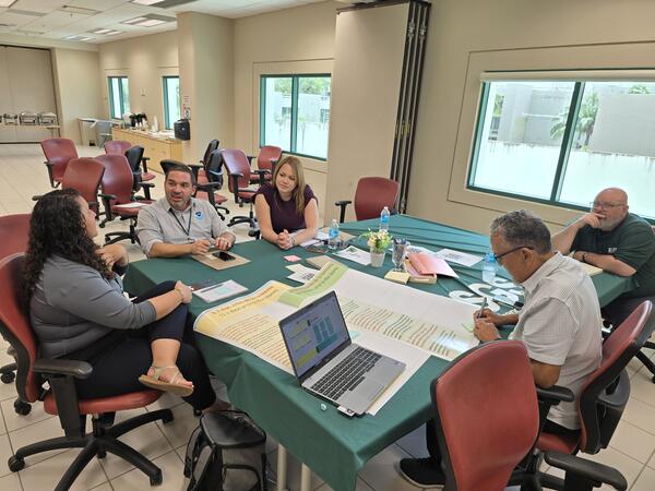
The Caribbean Coastal Ocean Observing System (CARICOOS) hosted a General Assembly May 26, 2023, in San Juan, Puerto Rico, and featured a presentation about USGS coastal hazards research, shoreline change geonarrative, natural hazards web pages, and other research related to the island.
Legna M Torres-García, Ph.D.
Legna M. Torres-García is a Research Oceanographer at the St. Petersburg Coastal and Marine Science Center in St. Petersburg, Florida.
Legna Torres García's work focuses on using multi-scale observational and numerical model data to understand circulation, waves, sediment transport, and coastal vulnerability. Her research includes simulations of hydrodynamics and coastal change in Puerto Rico and the Florida Keys. In addition, she is a principal investigator on a project on assessing the coastal vulnerability of communities in Puerto Rico through a focused stakeholder engagement approach. Her focus on both numerical model development and stakeholder engagement enables her to address community needs with the best available science.
Professional Experience
Research Oceanographer, U.S. Geological Survey, St. Petersburg Coastal & Marine Geology Science Center, 2022 to present
Postdoctoral Research Oceanographer, U.S. Geological Survey, St. Petersburg Coastal & Marine Geology Science Center, 2020 to 2022
Scientist, U.S. Geological Survey, St. Petersburg Coastal & Marine Geology Science Center, 2014 to 2016
Teaching Assistant, University of South Carolina, Geology Laboratory Coordinator
Education and Certifications
Ph.D., (2020), University of Florida, Major in Oceanographic and Coastal Engineering, Dissertation: Hydrodynamics and sediment mobility in degraded barrier coral reefs
M.S., (2014), University of South Carolina, Major in Geology; Earth and Ocean Sciences Department, Thesis: Flow Dynamics in the Transition Zone from Estuarine Tidal to Fluvial Regime
M.S., (2009), University of South Carolina, Major in Physics, Physics and Astronomy Department, Thesis: Search for Interstellar Silicate Dust in Four Quasar Absorber Galaxies
B.S., (2006), University of Puerto Rico, Mayagüez, Major in Physics, Physics Department
Science and Products
Incorporating Climate and Environmental Justice into Research and Resource Management: Skillsets & competencies integral to justice work
Improving Land Change Models for Climate Adaptation, Urban Development, and Conservation Action Across the US Caribbean
SENHIC Project Milestones and Meetings
Stakeholder Engagement for Natural Hazards Investigations in the Caribbean (SENHIC)
Puerto Rico Natural Hazards | Peligros naturales de Puerto Rico
Puerto Rico Natural Hazards: Coastal | Peligros naturales de Puerto Rico: Costas
Puerto Rico Natural Hazards: Ecosystems and Environmental Contaminants | Peligros naturales de Puerto Rico: Ecosistemas y contaminantes ambientales
Puerto Rico Natural Hazards: Hurricanes | Peligros naturales de Puerto Rico: Huracanes
Puerto Rico Natural Hazards: Landslides | Peligros naturales de Puerto Rico: Deslizamientos de tierra
Puerto Rico Natural Hazards: Water Resources | Peligros naturales de Puerto Rico: Recursos de agua
National Assessment of Hurricane-Induced Coastal Erosion Hazards: Puerto Rico
Grain-Size Data from Upper Florida Keys: Crocker Reef, FL
Ocean Currents and Pressure Time Series at the Upper Florida Keys: Crocker Reef, FL
The Caribbean Coastal Ocean Observing System (CARICOOS) hosted a General Assembly May 26, 2023, in San Juan, Puerto Rico, and featured a presentation about USGS coastal hazards research, shoreline change geonarrative, natural hazards web pages, and other research related to the island.
Meaghan Emory and Drs. Legna Torres-Garcia and Donya Frank-Gilchrist engage with stakeholders and explore potential partnerships across Caribbean nations and territories to further enhance USGS natural hazards research at the 2023 SCDRP annual meeting in Miami, Florida.
From left to right: Meaghan Emory, Dr. Donya Frank-Gilchrist, Dr.
La isla de Puerto Rico está sujeta a numerosos peligros naturales, incluyendo huracanes y erosión costera. La información sobre cómo responden los entornos costeros de la isla a estos eventos es fundamental para reforzar la resiliencia costera. La Dra.
The island of Puerto Rico is subject to numerous natural hazards including hurricanes and coastal erosion. Information on how the island’s coastal environments respond to these events is critical for bolstering coastal resilience. Dr.
A team of divers from the USGS St. Petersburg Coastal and Marine Science Center on a small boat off the coast of Puerto Rico. They deployed oceanographic instruments and wave buoys in 60m of water to measure waves, wind, and water levels.
Tres científicos del Servicio Geológico de los Estados Unidos en equipo de buceo instalando una boya de olas y un sensor de presión a 60 pies de profundad para medir las olas y niveles de agua en Isla Verde, Puerto Rico.
Three U.S. Geological Survey scientists in scuba gear work to install a wave buoy and pressure sensor 60 feet underwater to measure waves and water levels in Isla Verde, Puerto Rico.
Dr. Legna Torres-García of the St. Petersburg Coastal and Marine Science Center is leading an effort to build relationships with stakeholders on the island of Puerto Rico to better understand their needs for natural hazards data and resources and share information available from USGS that are relevant to the island.
A group of divers (from left to right: Legna Torres-Garcia, BJ Reynolds, and Dave Thompson) from the USGS St. Petersburg Coastal and Marine Science Center prepare to deploy a solar-powered Sofar spotter buoy off the coast of Puerto Rico.
A team from the USGS St. Petersburg Coastal and Marine Science Center went to Puerto Rico to install new Coast Cams to monitor how the beach and shoreline change through time. These cameras will allow the team to make predictions of how the coast will respond during storms and hurricanes.
The U.S. Geological Survey (USGS) recently installed camera systems and wave buoys in Dorado and Isla Verde, Puerto Rico to assist scientists with monitoring and predicting coastal change. The cameras provide near-real time images that can be viewed online.
Dr. Legna Torres-García conducts an erosion model activity at the LCC Day School in St. Petersburg, FL, to showcase how hurricane-force winds can cause damage to coastal environments.
Wooden boardwalk built to protect fragile dunes from pedestrians in Isabela, Puerto Rico.
Dune restoration efforts in Isabela, Puerto Rico, using wooden planks to promote sand accumulation.
Mangroves grow along the coast in La Parguera, Lajas, Puerto Rico. Mangroves help protect the coast during storms.
Coral reef in La Parguera, Lajas Puerto Rico shows a sea fan coral (Gorgonia) in the center, surrounded other corals and fishes.
Coral reef in La Parguera, Lajas Puerto Rico shows various types and conditions of corals, including sea fan corals (Gorgonia) in the center.
Buildings destroyed during Hurricane Maria in Rincón, Puerto Rico. Photograph taken on August 28, 2021, almost four years after the hurricane.
Hydrodynamics and sediment mobility processes over a degraded senile coral reef
Coral reefs can influence hydrodynamics and morphodynamics by dissipating and refracting incident wave energy, modifying circulation patterns, and altering sediment transport pathways. In this study, the sediment and hydrodynamic response of a senile (dead) barrier reef (Crocker Reef, located in the upper portion of the Florida Reef Tract) to storms and quiescent conditions was evaluated using fie
Ocean acidification buffering effects of seagrass in Tampa Bay
Investigación del USGS sobre el ecosistema de arrecifes de coral en el Atlántico
Los Cambios Costeros en Puerto Rico
El Servicio Geológico de los Estados Unidos (USGS, por sus siglas en inglés) ha desarrollado una geonarrativa en español e inglés sobre los cambios en la costa de Puerto Rico que explica las tendencias históricas de la línea costera de la isla, los impactos de los huracanes en la costa y las posibles soluciones para proteger a las comunidades y mitigar los peligros costeros.
Shoreline Changes in Puerto Rico
The United States Geological Survey (USGS) has developed a Spanish and English geonarrative that displays shoreline changes in Puerto Rico and covers topics on the island’s historical shoreline trends, hurricane impacts on the coast, and possible solutions that could help protect communities and mitigate coastal hazards.