
USGS Ocean Research

Detailed Description
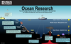
Our coasts, the most familiar part of the ocean are the gateway to the larger deeper ocean world. USGS studies processes and hazards in the coastal zone and how they affect people, wildlife, and ecosystems. Coastal areas extend seaward across the continental shelf, where ocean currents move, creating and connecting many ecologically and economically important ecosystems and habitats such as seagrass beds, coral reefs, and kelp forests. USGS is involved in mapping the boundary between the shelf and the continental slope where the shelf descends to the abyssal plain of the deep ocean, which are often carved by submarine canyons. USGS brings expertise to mapping the shelf/slope boundary, which includes determining the extent of the U.S. Extended Continental Shelf to better protect, manage, and use the seabed resources that occur there. These shelf and slope areas are of great interest for determining the presence and threats of marine geohazards (such as underwater landslides that can trigger tsunamis) and unique chemistry associated with hydrothermal vents and gas hydrates that support unique ecosystems. In addition, coastal areas are connected to the deep sea through the submarine canyons where sediments and nutrients flow off the shelf and into the deep sea. The canyon areas are homes for diverse array of deep sea life like deep-water corals, sponges, crustaceans and unique microbial communities. Now that you know your way around the ocean, learn more about USGS research by exploring our Ocean Topics and Ocean 101.
Sources/Usage
Public Domain.
Graphic by Betsy Boynton. Science advisor: Meaghan Emory. Some symbols courtesy of IAN/UMCES Symbol and Image Libraries (Attribution-ShareAlike 4.0 International (CC BY-SA 4.0)). Humpback anglerfish courtesy of Wikipedia, by August Brauer (1863–1917).