Phreatic eruption on Mount St. Helens pre-May 18, 1981
Phreatic eruption on Mount St. Helens pre-May 18, 1981View from the northwest of a phreatic eruption on Mount St. Helens pre- May 18, 1980 eruption.

Official websites use .gov
A .gov website belongs to an official government organization in the United States.
Secure .gov websites use HTTPS
A lock () or https:// means you’ve safely connected to the .gov website. Share sensitive information only on official, secure websites.
Images related to natural hazards.

View from the northwest of a phreatic eruption on Mount St. Helens pre- May 18, 1980 eruption.
View from the northwest of a phreatic eruption on Mount St. Helens pre- May 18, 1980 eruption.

View from the north of Mount St. Helens' eruption and first crater.
View from the north of Mount St. Helens' eruption and first crater.

An east-west fault across middle of summit area and an uplift or bulge on upper north flank of the volcano are also visible in this photo.
An east-west fault across middle of summit area and an uplift or bulge on upper north flank of the volcano are also visible in this photo.

Although seismic activity began under Mount St. Helens on March 20, this overflight showed no unusual features except numerous tracks of earthquake-triggered snow avalanches. No evidence of fracturing of summit area was detected during careful visual observations on the afternoon of March 24, 1980.
Although seismic activity began under Mount St. Helens on March 20, this overflight showed no unusual features except numerous tracks of earthquake-triggered snow avalanches. No evidence of fracturing of summit area was detected during careful visual observations on the afternoon of March 24, 1980.

Before the devastating May 18, 1980 eruption, Mount St. Helens was considered to be one of the most beautiful and most frequently-climbed peaks in the Cascade Range. Spirit Lake was a vacation area offering hiking, camping, boating, and fishing.
Before the devastating May 18, 1980 eruption, Mount St. Helens was considered to be one of the most beautiful and most frequently-climbed peaks in the Cascade Range. Spirit Lake was a vacation area offering hiking, camping, boating, and fishing.
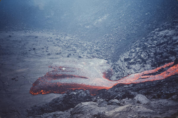
The November 16, 1979, eruption near Pauahi Crater was a brief, one-day event on the upper East Rift Zone. It was preceded by two months of increased seismic activity, summit inflation, and lava erupting from fissures west of, within, and east of the crater.
The November 16, 1979, eruption near Pauahi Crater was a brief, one-day event on the upper East Rift Zone. It was preceded by two months of increased seismic activity, summit inflation, and lava erupting from fissures west of, within, and east of the crater.

Summit region (Kalama age–1479 to 1720 C.E.) of Mount St. Helens looking northeast. Spirit Lake and Mount Adams in background. September 28, 1979.
Summit region (Kalama age–1479 to 1720 C.E.) of Mount St. Helens looking northeast. Spirit Lake and Mount Adams in background. September 28, 1979.

Before the eruption of May 18, 1980, Mount St. Helens' elevation was 2,950 m (9,677 ft). View from the west, Mount Adams in distance. S. Fork Toutle River is valley in center of photo.
Mount Adams elevation is 3,745 m (12, 286 ft). Mount St. Helens was the smallest of five major volcanic peaks in Washington State.

Worm Complex on the southeast flank of Mount St. Helens—Middle Kalama lava flows in center of image. Photo from September 28, 1979. Click to view larger image.
Worm Complex on the southeast flank of Mount St. Helens—Middle Kalama lava flows in center of image. Photo from September 28, 1979. Click to view larger image.

Studebaker Ridge formed during the Tertiary geologic time period (65 million to 2.6 million years ago). The pyroclastic surge from the May 18, 1980 eruption destroyed the trees on the ridge.
Studebaker Ridge formed during the Tertiary geologic time period (65 million to 2.6 million years ago). The pyroclastic surge from the May 18, 1980 eruption destroyed the trees on the ridge.

East Dome erupted during Sugar Bowl time (C.E. 850-900) east flank view of Mount St. Helens. Kalama age (erupted about 1535) andesite flows surround dome.
East Dome erupted during Sugar Bowl time (C.E. 850-900) east flank view of Mount St. Helens. Kalama age (erupted about 1535) andesite flows surround dome.

Mount St. Helens one year prior to the May 18, 1980, catastrophic eruption, showing glaciers at the summit.
Mount St. Helens one year prior to the May 18, 1980, catastrophic eruption, showing glaciers at the summit.
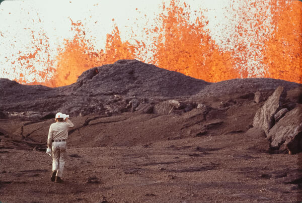
The September 1977 eruption of Kīlauea began after nearly two years of dormancy, with activity breaking out on September 13 along a 3.5-mile-long fissure system between the prehistoric cones of Kalalua and Puʻu Kauka.
The September 1977 eruption of Kīlauea began after nearly two years of dormancy, with activity breaking out on September 13 along a 3.5-mile-long fissure system between the prehistoric cones of Kalalua and Puʻu Kauka.

Three Fingered Jack (2390 m or 7840 ft) is a volcanic peak in central Oregon near Mount Bachelor and the Three Sisters. Black Butte is in the background.
Three Fingered Jack (2390 m or 7840 ft) is a volcanic peak in central Oregon near Mount Bachelor and the Three Sisters. Black Butte is in the background.

Mount Konocti, a mostly dacitic composite cone, on the western shore of Clear Lake, California. Thurston Lake is in the foreground.
Mount Konocti, a mostly dacitic composite cone, on the western shore of Clear Lake, California. Thurston Lake is in the foreground.

The magnitude-7.7 earthquake caused a nearly continuous zone of ground cracking and faulting for about 25 km (15 mi) along the south flank inland of Halapē.
The magnitude-7.7 earthquake caused a nearly continuous zone of ground cracking and faulting for about 25 km (15 mi) along the south flank inland of Halapē.

A M 7.7 earthquake on November 29, 1975, was located beneath the south flank of Kīlauea.
A M 7.7 earthquake on November 29, 1975, was located beneath the south flank of Kīlauea.

Fractures in Crater Rim Road, Hawai‘i Volcanoes National Park, caused by the November 29, 1975, earthquake beneath the south flank of Kīlauea Volcano. Only a few meters (yards) from Kīlauea's summit crater (out of sight left of guardrails), large sections adjacent the crater wall slumped toward the crater, forming these fractures.
Fractures in Crater Rim Road, Hawai‘i Volcanoes National Park, caused by the November 29, 1975, earthquake beneath the south flank of Kīlauea Volcano. Only a few meters (yards) from Kīlauea's summit crater (out of sight left of guardrails), large sections adjacent the crater wall slumped toward the crater, forming these fractures.

This part of the south flank of Kīlauea Volcano moved seaward about 6 m (20 ft) and subsided about 3.5 m (11.5 ft) as a result of the magnitude-7.7 earthquake. A tsunami swept ashore at Halapē and reached 14.6 m (48 ft) above the post-earthquake shoreline.
This part of the south flank of Kīlauea Volcano moved seaward about 6 m (20 ft) and subsided about 3.5 m (11.5 ft) as a result of the magnitude-7.7 earthquake. A tsunami swept ashore at Halapē and reached 14.6 m (48 ft) above the post-earthquake shoreline.

At 04:48 HST that morning, a magnitude-7.7 earthquake shook the island and generated a local tsunami that killed 2 people. Strong shaking from the earthquake produced damage at many locations on the Island of Hawai‘i. Within Hawai‘i Volcanoes National Park, sections of Crater Rim Drive (shown in this photo) cracked, some slumped toward the crater.
At 04:48 HST that morning, a magnitude-7.7 earthquake shook the island and generated a local tsunami that killed 2 people. Strong shaking from the earthquake produced damage at many locations on the Island of Hawai‘i. Within Hawai‘i Volcanoes National Park, sections of Crater Rim Drive (shown in this photo) cracked, some slumped toward the crater.

Ground cracks along Crater Rim Drive in Hawai‘i Volcanoes National Park caused by the M 7.7 earthquake on November 25, 1975. The cracks resulted from slumping of the ground toward the rim of Kīlauea Crater, the edge of which is left of the guardrails.
Ground cracks along Crater Rim Drive in Hawai‘i Volcanoes National Park caused by the M 7.7 earthquake on November 25, 1975. The cracks resulted from slumping of the ground toward the rim of Kīlauea Crater, the edge of which is left of the guardrails.