
Integrated Water Science Basins: Upper Colorado River
The Upper Colorado River Basin's snowpacks serve as vast natural water reservoirs
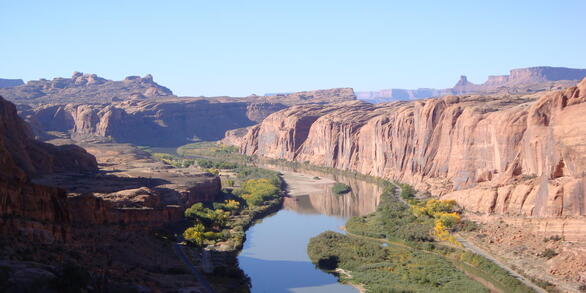
The Upper Colorado River Basin is a vital source of water for millions
USGS has been studying Upper Colorado River Basin hydrology since 1869.
From Snow to Flow: Understanding snow water in the Upper Colorado River Basin
The Upper Colorado River Basin (UCRB) provides drinking water for 40 million people in the United States and Mexico. USGS research in the UCRB examines the key potential factors affecting water supply in the upper portion of the basin—snow processes and water storage, wildfire and basin hydrology, and salinity concentrations and water quality.
Key Messages
- In 2019, the USGS selected the Upper Colorado River Basin (UCRB) as the second of up to ten planned Integrated Water Science (IWS) basins. The UCRB was chosen because it represents the importance of snow conditions to water availability for human and ecosystem use.
- The Colorado River Basin is an important water source for more than 40 million people in the Western United States and Mexico, providing water to major cities and irrigating agricultural land. However, since 2000, the region has faced prolonged drought conditions, leading to record low levels in Lake Mead and Lake Powell and resulting in water usage restrictions.
- The USGS plays a key role in studying the Colorado River Basin water supply. Understanding the processes that can affect water supply in the upper portion of the basin could be crucial for supporting human, agricultural, and ecological needs across a large spatial scale.
- The UCRB IWS effort is planned to span 10 years and is divided into two phases:
- Phase 1 (2021–2025) is focused on understanding how snow accumulation and melt processes contribute to water availability and total dissolved solids (salinity) concentrations and loads.
- Phase 2 (2026–2030) will focus on a broader evaluation of water availability in the region.
- The UCRB Next Generation Water Observing System (NGWOS) effort is planned to span 10 years and is divided into three phases.
- Phase 1 (2019—2020) focused on identifying existing tools and data, stakeholder input, and strategic planning.
- Phase 2 (2021-2023) focused on installation of new NGWOS monitoring equipment and instrumentation, develop data connections, and continued research and development.
- Phase 3 (2024-2028) is focused on continued operation and maintenance of NGWOS deployments.
- The UCRB IWS effort is planned to span 10 years and is divided into two phases:
About the Upper Colorado River Basin
UCRB Geography and Water Rights

The Colorado River and its tributaries supply drinking water for 40 million people in the U.S. and Mexico, irrigation water for 5.5 million acres of land, and are essential sources of water for at least 29 federally recognized tribes, 7 National Wildlife Refuges, 4 National Recreation Areas, and 11 National Parks. The Colorado River Compact of 1922 divided the Colorado River into upper and lower basins at Lees Ferry, Arizona. The Compact divides water in the Colorado River equally between the upper and lower basin states, with each basin receiving 7.5 million acre-feet (maf) per year. An additional 1.5 maf per year of Colorado River water is guaranteed to Mexico, per a 1944 treaty.
The water in the Colorado River was apportioned based on hydrologic data that are now known to have been collected during an unusually wet period in the upper basin. Present day normal flow conditions may not produce sufficient water for all apportioned uses. Extended drought and patterns of aridification in the basin may have a profound effect on resulting streamflow and resulting reservoir storage in the UCRB. These issues are likely to create challenges for water managers to deliver on compact and treaty agreements. The IWS work will provide basin stakeholders and managers with an improved understanding of past, current, and future water supply that is needed to determine if there will be enough water of suitable quality to meet a multitude of human and ecosystem demands.

UCRB Hydrography and Water Availability
The primary sources of water in the UCRB are the annual winter snowpack in the mountains and the resulting spring snowmelt that flows down through tributaries of the Colorado River. High-altitude areas are cold enough to receive most of their precipitation as winter snow that accumulates as a seasonal snowpack. These areas produce a large portion of the runoff to streams in the basin: about 15 percent of the basin area contributes about 85 percent of the mean-annual runoff. Changes in weather patterns are affecting the amount of snow accumulation, the timing of snow melt, and the relative contribution of precipitation that falls as rain versus snow.
The effect of salinity, or dissolved solids, on water availability for human and ecosystem use is also a major concern in the Colorado River Basin in both the United States and Mexico, with quantified damages estimated to be about \$447 million per year at 2023 salinity concentrations. These economic damages are mostly from corrosion and reduced agricultural yields. The Colorado River is naturally saline because of the underlying geology and arid climate, although both natural and human sources contribute to the river's salinity levels. Recent work suggests that groundwater is a critical resource for sustaining streamflow as well as a source of salinity.
Because groundwater and surface water are a single, interconnected resource, future management practices that collectively manage groundwater and surface water may be required to maximize available water in the basin. Changes in water supply and demand in the basin, including a 20-plus year ongoing drought, are expected to continue in the future, and projecting the effects of these changes on water availability will help inform future water planning efforts to meet human and ecosystem needs.
Overview of UCRB Research Priorities and Plans
With so many people relying on water from the Colorado River, studying the UCRB is important for a variety of reasons--and no issue affects UCRB communities more than better defining snowmelt runoff. Snow accumulation is the primary source of water availability in the Colorado River basin, driving streamflow, salinity transport and storage, and stream temperature.
USGS scientists aim to improve our understanding of how snow accumulation and melt processes contribute to surface and groundwater availability (quantity and dissolved solids) for human and ecological use as environmental conditions change.
Regional Water Availability Assessment Overview

Regional Water Availability Assessments are scientific assessments of water availability in different hydrologic regions across the Nation. In the UCRB, the USGS is conducting a focused study of how snowpack and snowmelt influence hydrology and water quality as part of an integrated and comprehensive evaluation of multiple water quantity, quality, and use factors.
Regional Water Availability Assessments evaluate water quantity and quality in both surface and groundwater, determine whether there is enough water for human and ecosystem needs, and investigate how human and natural influences affect the amount of available water. Specifically, the Regional Water Availability Assessment research scientists in the UCRB are addressing questions such as:
- How have changes in snowpack in the UCRB headwaters translated to changes in other water budget components throughout the basin and how will these changes vary in the future?
- What is the sensitivity of total dissolved solids (like salt) concentrations and loads to changes in snow hydrology?
- What factors affect water availability in the UCRB, including water quantity, quality, and use.
Next Generation Water Observing System (NGWOS) Overview

The NGWOS provides high-fidelity, real-time data on water quantity, quality, and use to support modern prediction and decision support systems that are necessary for informing water operations on a daily basis and decision-making during water emergencies.To better address how snowmelt affects the UCRB flow regime, NGWOS has expanded monitoring of snow, water temperature, streamflow, groundwater, and water quality in the Colorado River Headwaters & Gunnison River subbasins. These subbasins provide an opportunity to implement NGWOS in a snowmelt-dominated system in the mountain west.
Below are other projects associated with the Upper Colorado River IWS Basin

Integrated Water Science (IWS) Basins

National Water Availability Assessment Release
This recorded webinar details the significance and finding of the National Water Availability Assessment Release. This new assessment is the first of its kind, offering new insights on where there is a potential imbalance between water supply and demand in the United States. The assessment uses state-of-the-art models to fill in gaps between monitoring sites and sampling events and integrates...
Below are news releases and announcements associated with the Upper Colorado River Integrated Water Science Basin.

USGS Program Tackles Complex Water Questions USGS Program Tackles Complex Water Questions
The Upper Colorado River Basin (UCRB) provides drinking water for 40 million people in the United States and Mexico. USGS research in the UCRB examines the key potential factors affecting water supply in the upper portion of the basin—snow processes and water storage, wildfire and basin hydrology, and salinity concentrations and water quality.
Key Messages
- In 2019, the USGS selected the Upper Colorado River Basin (UCRB) as the second of up to ten planned Integrated Water Science (IWS) basins. The UCRB was chosen because it represents the importance of snow conditions to water availability for human and ecosystem use.
- The Colorado River Basin is an important water source for more than 40 million people in the Western United States and Mexico, providing water to major cities and irrigating agricultural land. However, since 2000, the region has faced prolonged drought conditions, leading to record low levels in Lake Mead and Lake Powell and resulting in water usage restrictions.
- The USGS plays a key role in studying the Colorado River Basin water supply. Understanding the processes that can affect water supply in the upper portion of the basin could be crucial for supporting human, agricultural, and ecological needs across a large spatial scale.
- The UCRB IWS effort is planned to span 10 years and is divided into two phases:
- Phase 1 (2021–2025) is focused on understanding how snow accumulation and melt processes contribute to water availability and total dissolved solids (salinity) concentrations and loads.
- Phase 2 (2026–2030) will focus on a broader evaluation of water availability in the region.
- The UCRB Next Generation Water Observing System (NGWOS) effort is planned to span 10 years and is divided into three phases.
- Phase 1 (2019—2020) focused on identifying existing tools and data, stakeholder input, and strategic planning.
- Phase 2 (2021-2023) focused on installation of new NGWOS monitoring equipment and instrumentation, develop data connections, and continued research and development.
- Phase 3 (2024-2028) is focused on continued operation and maintenance of NGWOS deployments.
- The UCRB IWS effort is planned to span 10 years and is divided into two phases:
About the Upper Colorado River Basin
UCRB Geography and Water Rights
The Colorado River and its tributaries supply drinking water for 40 million people in the U.S. and Mexico, irrigation water for 5.5 million acres of land, and are essential sources of water for at least 29 federally recognized tribes, 7 National Wildlife Refuges, 4 National Recreation Areas, and 11 National Parks. The Colorado River Compact of 1922 divided the Colorado River into upper and lower basins at Lees Ferry, Arizona. The Compact divides water in the Colorado River equally between the upper and lower basin states, with each basin receiving 7.5 million acre-feet (maf) per year. An additional 1.5 maf per year of Colorado River water is guaranteed to Mexico, per a 1944 treaty.
The water in the Colorado River was apportioned based on hydrologic data that are now known to have been collected during an unusually wet period in the upper basin. Present day normal flow conditions may not produce sufficient water for all apportioned uses. Extended drought and patterns of aridification in the basin may have a profound effect on resulting streamflow and resulting reservoir storage in the UCRB. These issues are likely to create challenges for water managers to deliver on compact and treaty agreements. The IWS work will provide basin stakeholders and managers with an improved understanding of past, current, and future water supply that is needed to determine if there will be enough water of suitable quality to meet a multitude of human and ecosystem demands.
UCRB Hydrography and Water Availability
The primary sources of water in the UCRB are the annual winter snowpack in the mountains and the resulting spring snowmelt that flows down through tributaries of the Colorado River. High-altitude areas are cold enough to receive most of their precipitation as winter snow that accumulates as a seasonal snowpack. These areas produce a large portion of the runoff to streams in the basin: about 15 percent of the basin area contributes about 85 percent of the mean-annual runoff. Changes in weather patterns are affecting the amount of snow accumulation, the timing of snow melt, and the relative contribution of precipitation that falls as rain versus snow.
The effect of salinity, or dissolved solids, on water availability for human and ecosystem use is also a major concern in the Colorado River Basin in both the United States and Mexico, with quantified damages estimated to be about \$447 million per year at 2023 salinity concentrations. These economic damages are mostly from corrosion and reduced agricultural yields. The Colorado River is naturally saline because of the underlying geology and arid climate, although both natural and human sources contribute to the river's salinity levels. Recent work suggests that groundwater is a critical resource for sustaining streamflow as well as a source of salinity.
Because groundwater and surface water are a single, interconnected resource, future management practices that collectively manage groundwater and surface water may be required to maximize available water in the basin. Changes in water supply and demand in the basin, including a 20-plus year ongoing drought, are expected to continue in the future, and projecting the effects of these changes on water availability will help inform future water planning efforts to meet human and ecosystem needs.
Overview of UCRB Research Priorities and Plans
With so many people relying on water from the Colorado River, studying the UCRB is important for a variety of reasons--and no issue affects UCRB communities more than better defining snowmelt runoff. Snow accumulation is the primary source of water availability in the Colorado River basin, driving streamflow, salinity transport and storage, and stream temperature.
USGS scientists aim to improve our understanding of how snow accumulation and melt processes contribute to surface and groundwater availability (quantity and dissolved solids) for human and ecological use as environmental conditions change.
Regional Water Availability Assessment Overview
Regional Water Availability Assessments are scientific assessments of water availability in different hydrologic regions across the Nation. In the UCRB, the USGS is conducting a focused study of how snowpack and snowmelt influence hydrology and water quality as part of an integrated and comprehensive evaluation of multiple water quantity, quality, and use factors.
Regional Water Availability Assessments evaluate water quantity and quality in both surface and groundwater, determine whether there is enough water for human and ecosystem needs, and investigate how human and natural influences affect the amount of available water. Specifically, the Regional Water Availability Assessment research scientists in the UCRB are addressing questions such as:
- How have changes in snowpack in the UCRB headwaters translated to changes in other water budget components throughout the basin and how will these changes vary in the future?
- What is the sensitivity of total dissolved solids (like salt) concentrations and loads to changes in snow hydrology?
- What factors affect water availability in the UCRB, including water quantity, quality, and use.
Next Generation Water Observing System (NGWOS) Overview
The NGWOS provides high-fidelity, real-time data on water quantity, quality, and use to support modern prediction and decision support systems that are necessary for informing water operations on a daily basis and decision-making during water emergencies.To better address how snowmelt affects the UCRB flow regime, NGWOS has expanded monitoring of snow, water temperature, streamflow, groundwater, and water quality in the Colorado River Headwaters & Gunnison River subbasins. These subbasins provide an opportunity to implement NGWOS in a snowmelt-dominated system in the mountain west.
Below are other projects associated with the Upper Colorado River IWS Basin
Integrated Water Science (IWS) Basins
National Water Availability Assessment Release
This recorded webinar details the significance and finding of the National Water Availability Assessment Release. This new assessment is the first of its kind, offering new insights on where there is a potential imbalance between water supply and demand in the United States. The assessment uses state-of-the-art models to fill in gaps between monitoring sites and sampling events and integrates...
Below are news releases and announcements associated with the Upper Colorado River Integrated Water Science Basin.