
National Brackish Groundwater Assessment: Pilot Saline Studies
Three pilot studies were conducted (2010-2012) to assess saline groundwater resources at regional scales. The goals of the pilot studies were to determine the availability of data for assessing the distribution and character of saline groundwater and test and develop methodologies for assessing the resource.
Southern Midcontinent Pilot Study

Principal Investigator: Noel Osborn
The hydrogeology, distribution, and volume of saline water in 22 aquifers in the southern midcontinent of the United States were evaluated to provide information about saline groundwater resources that may be used to reduce dependency on freshwater resources. Those aquifers underlie six States in the southern midcontinent-Arkansas, Kansas, Louisiana, Missouri, Oklahoma, and Texas-and adjacent areas including all or parts of Alabama, Colorado, Florida, Illinois, Kentucky, Mississippi, Nebraska, New Mexico, South Dakota, Tennessee, and Wyoming and some offshore areas of the Gulf of America. Saline waters of the aquifers were evaluated by defining salinity zones; digitizing data, primarily from the Regional Aquifer-System Analysis Program of the U.S. Geological Survey; and computing the volume of saline water in storage.
The distribution of saline groundwater in the southern midcontinent is substantially affected by the hydrogeology and groundwater-flow systems of the aquifers. Many of the aquifers in the southern midcontinent are underlain by one or more aquifers, resulting in vertically stacked aquifers containing groundwaters of varying salinity. Saline groundwater is affected by past and present hydrogeologic conditions. Spatial variation of groundwater salinity in the southern midcontinent is controlled primarily by locations of recharge and discharge areas, groundwater-flow paths and residence time, mixing of freshwater and saline water, and interactions with aquifer rocks and sediments.
- Osborn, N.I., Smith, S.J., and Seger, C.H., 2013, Hydrogeology, distribution, and volume of saline groundwater in the southern midcontinent and adjacent areas of the United States: U.S. Geological Survey Scientific Investigations Report 2013-5017, 58 p.
Southeastern United States Pilot Study
Principal Investigator: Lester Williams

Brackish and saline groundwater resources were assessed in two regional aquifer systems in the southeastern United States to determine their potential for supplementing existing freshwater supplies in the area. These resources were mapped in terms of their dissolved-solids concentrations, estimated mostly from borehole geophysical logs, and supplemented with water-quality data collected from wells with known open intervals. Maps and cross sections were constructed for each of the major hydrogeologic units that depict salinity variations in four zones:
- the freshwater zone, containing dissolved-solids of less than 1,000 milligrams per liter (mg/L);
- the brackish-water zone, containing between 1,000 and 10,000 mg/L of dissolved solids;
- the salinity transition zone, containing between 10,000 and 35,000 mg/L of dissolved solids; and
- the saline-water zone, containing between 35,000 and 100,000 mg/L of dissolved solids.
The brine zone, containing greater than 100,000 mg/L of dissolved solids, was not differentiated from the saline-water zone.
The results of the study indicate brackish groundwater resources are present in a variety of clastic and carbonate rock aquifers ranging in depth from a few hundred feet to several thousand feet or more. Brackish zones were mapped in two aquifers of the Southeastern Coastal Plain aquifer system (the Chattahoochee River aquifer and Black Warrior River aquifer) and two aquifers of the Floridan aquifer system (the Upper and Lower Floridan aquifers). Because of differences in permeability, proximity to recharge areas, and the local presence of relict seawater or brine that has not been fully flushed out of the freshwater flow system, vertical and lateral salinity variations in successively deeper aquifers can be complex. A cross section through southeastern Georgia demonstrates the varying extents of brackish water zones in the Southeastern Coastal Plain and Floridan aquifer systems. Regionally, the shallowest and most accessible brackish groundwater resources are present in the Upper Floridan aquifer, mostly in coastal areas of Georgia, Alabama, South Carolina, and throughout most of the coastal areas in Florida. Deeper, less accessible aquifers containing brackish groundwater resources are present throughout much of the Southeastern Coastal Plain aquifer system in Georgia, Alabama, and South Carolina.
Additional study will be needed to assess the extent, water quality, and potential of using brackish- and saline-water resources to supplement existing freshwater supplies. Major considerations for development include the depth and cost of drilling into these deeper zones, alternatives for brine disposal that may be associated with treatment of brackish water, and the potential yield of these aquifers.
- Miller, J.A., 1986, Hydrogeologic framework of the Floridan aquifer system in Florida and in parts of Georgia, South Carolina, and Alabama: U.S. Geological Survey Professional Paper 1403-B, 91 p. and 33 pl.
- Renken, R.A., 1996, Hydrogeology of the Southeastern Coastal Plain aquifer system in Mississippi, Alabama, Georgia, and South Carolina: U.S. Geological Survey Professional Paper 1410-B, 101 p., 42 pl.
- Williams, L.J., Raines, J.E., and Lanning, A.E., 2013, Geophysical log database for the Floridan aquifer system and southeastern Coastal Plain aquifer system in Florida and parts of Georgia, Alabama, and South Carolina: U.S. Geological Survey Data Series 760
Cretaceous Aquifer System of the Mississippi Embayment Pilot Study
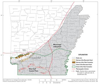
Principal Investigator: Jonathan Gillip
The Mississippi Embayment and underlying Cretaceous groundwater systems are rich in water resources. However, large areas of aquifers have elevated total dissolved-solids concentrations. The Nacatoch Sand and the Tokio Formation of the Cretaceous aquifer system were chosen for investigation since the aquifers are known to have increased salinity as the distance from the outcrop increases. Limited water-quality data are available for deeper aquifers, as other shallower aquifers are used for water supply. Historical geophysical logs were used to determine the properties of the deeper aquifers and the quality of the water contained within. Based on the results of this study, in Arkansas, the Nacatoch Sand contains over 80 million acre feet of water with a TDS (total dissolved solids) concentration between 1,000 and 10,000 mg/L, over 60 million acre feet of water with a TDS concentration between 10,000 and 35,000 mg/L, and nearly 180 million acre feet of water with a TDS concentration over 35,000 mg/L. The Tokio formation, in Arkansas contains over 18 million acre feet of water with a TDS concentration between 1,000 and 10,000 mg/L, over 40 million acre feet of water with a TDS concentration between 10,000 and 35,000 mg/L, and nearly 145 million acre feet of water with a TDS concentration over 35,000 mg/L.
- Gillip, J.A., 2014, Characterization of the structure, clean-sand percentage, dissolved-solids concentrations, and estimated quantity of groundwater in the Upper Cretaceous Nacatoch Sand and Tokio Formation, Arkansas: U.S. Geological Survey Scientific Investigations Report 2014-5068, 23 p.
Below are other science projects associated with the National Brackish Groundwater Assessment.

Brackish Groundwater Assessment

About the USGS National Brackish Groundwater Assessment

National Brackish Groundwater Assessment: Sources of Dissolved Solids in Brackish Groundwater

National Brackish Groundwater Assessment: How is Brackish Groundwater Being Used?

National Brackish Groundwater Assessment: Previous Work
Three pilot studies were conducted (2010-2012) to assess saline groundwater resources at regional scales. The goals of the pilot studies were to determine the availability of data for assessing the distribution and character of saline groundwater and test and develop methodologies for assessing the resource.
Southern Midcontinent Pilot Study
Principal Investigator: Noel Osborn
The hydrogeology, distribution, and volume of saline water in 22 aquifers in the southern midcontinent of the United States were evaluated to provide information about saline groundwater resources that may be used to reduce dependency on freshwater resources. Those aquifers underlie six States in the southern midcontinent-Arkansas, Kansas, Louisiana, Missouri, Oklahoma, and Texas-and adjacent areas including all or parts of Alabama, Colorado, Florida, Illinois, Kentucky, Mississippi, Nebraska, New Mexico, South Dakota, Tennessee, and Wyoming and some offshore areas of the Gulf of America. Saline waters of the aquifers were evaluated by defining salinity zones; digitizing data, primarily from the Regional Aquifer-System Analysis Program of the U.S. Geological Survey; and computing the volume of saline water in storage.
The distribution of saline groundwater in the southern midcontinent is substantially affected by the hydrogeology and groundwater-flow systems of the aquifers. Many of the aquifers in the southern midcontinent are underlain by one or more aquifers, resulting in vertically stacked aquifers containing groundwaters of varying salinity. Saline groundwater is affected by past and present hydrogeologic conditions. Spatial variation of groundwater salinity in the southern midcontinent is controlled primarily by locations of recharge and discharge areas, groundwater-flow paths and residence time, mixing of freshwater and saline water, and interactions with aquifer rocks and sediments.
- Osborn, N.I., Smith, S.J., and Seger, C.H., 2013, Hydrogeology, distribution, and volume of saline groundwater in the southern midcontinent and adjacent areas of the United States: U.S. Geological Survey Scientific Investigations Report 2013-5017, 58 p.
Southeastern United States Pilot Study
Principal Investigator: Lester Williams
Brackish and saline groundwater resources were assessed in two regional aquifer systems in the southeastern United States to determine their potential for supplementing existing freshwater supplies in the area. These resources were mapped in terms of their dissolved-solids concentrations, estimated mostly from borehole geophysical logs, and supplemented with water-quality data collected from wells with known open intervals. Maps and cross sections were constructed for each of the major hydrogeologic units that depict salinity variations in four zones:
- the freshwater zone, containing dissolved-solids of less than 1,000 milligrams per liter (mg/L);
- the brackish-water zone, containing between 1,000 and 10,000 mg/L of dissolved solids;
- the salinity transition zone, containing between 10,000 and 35,000 mg/L of dissolved solids; and
- the saline-water zone, containing between 35,000 and 100,000 mg/L of dissolved solids.
The brine zone, containing greater than 100,000 mg/L of dissolved solids, was not differentiated from the saline-water zone.
The results of the study indicate brackish groundwater resources are present in a variety of clastic and carbonate rock aquifers ranging in depth from a few hundred feet to several thousand feet or more. Brackish zones were mapped in two aquifers of the Southeastern Coastal Plain aquifer system (the Chattahoochee River aquifer and Black Warrior River aquifer) and two aquifers of the Floridan aquifer system (the Upper and Lower Floridan aquifers). Because of differences in permeability, proximity to recharge areas, and the local presence of relict seawater or brine that has not been fully flushed out of the freshwater flow system, vertical and lateral salinity variations in successively deeper aquifers can be complex. A cross section through southeastern Georgia demonstrates the varying extents of brackish water zones in the Southeastern Coastal Plain and Floridan aquifer systems. Regionally, the shallowest and most accessible brackish groundwater resources are present in the Upper Floridan aquifer, mostly in coastal areas of Georgia, Alabama, South Carolina, and throughout most of the coastal areas in Florida. Deeper, less accessible aquifers containing brackish groundwater resources are present throughout much of the Southeastern Coastal Plain aquifer system in Georgia, Alabama, and South Carolina.
Additional study will be needed to assess the extent, water quality, and potential of using brackish- and saline-water resources to supplement existing freshwater supplies. Major considerations for development include the depth and cost of drilling into these deeper zones, alternatives for brine disposal that may be associated with treatment of brackish water, and the potential yield of these aquifers.
- Miller, J.A., 1986, Hydrogeologic framework of the Floridan aquifer system in Florida and in parts of Georgia, South Carolina, and Alabama: U.S. Geological Survey Professional Paper 1403-B, 91 p. and 33 pl.
- Renken, R.A., 1996, Hydrogeology of the Southeastern Coastal Plain aquifer system in Mississippi, Alabama, Georgia, and South Carolina: U.S. Geological Survey Professional Paper 1410-B, 101 p., 42 pl.
- Williams, L.J., Raines, J.E., and Lanning, A.E., 2013, Geophysical log database for the Floridan aquifer system and southeastern Coastal Plain aquifer system in Florida and parts of Georgia, Alabama, and South Carolina: U.S. Geological Survey Data Series 760
Cretaceous Aquifer System of the Mississippi Embayment Pilot Study
Principal Investigator: Jonathan Gillip
The Mississippi Embayment and underlying Cretaceous groundwater systems are rich in water resources. However, large areas of aquifers have elevated total dissolved-solids concentrations. The Nacatoch Sand and the Tokio Formation of the Cretaceous aquifer system were chosen for investigation since the aquifers are known to have increased salinity as the distance from the outcrop increases. Limited water-quality data are available for deeper aquifers, as other shallower aquifers are used for water supply. Historical geophysical logs were used to determine the properties of the deeper aquifers and the quality of the water contained within. Based on the results of this study, in Arkansas, the Nacatoch Sand contains over 80 million acre feet of water with a TDS (total dissolved solids) concentration between 1,000 and 10,000 mg/L, over 60 million acre feet of water with a TDS concentration between 10,000 and 35,000 mg/L, and nearly 180 million acre feet of water with a TDS concentration over 35,000 mg/L. The Tokio formation, in Arkansas contains over 18 million acre feet of water with a TDS concentration between 1,000 and 10,000 mg/L, over 40 million acre feet of water with a TDS concentration between 10,000 and 35,000 mg/L, and nearly 145 million acre feet of water with a TDS concentration over 35,000 mg/L.
- Gillip, J.A., 2014, Characterization of the structure, clean-sand percentage, dissolved-solids concentrations, and estimated quantity of groundwater in the Upper Cretaceous Nacatoch Sand and Tokio Formation, Arkansas: U.S. Geological Survey Scientific Investigations Report 2014-5068, 23 p.
Below are other science projects associated with the National Brackish Groundwater Assessment.
Brackish Groundwater Assessment
About the USGS National Brackish Groundwater Assessment
National Brackish Groundwater Assessment: Sources of Dissolved Solids in Brackish Groundwater
National Brackish Groundwater Assessment: How is Brackish Groundwater Being Used?