
New backcountry alert system warns Grand Canyon visitors about flash floods in areas without cellular signal
Visitors can subscribe to the alert system using satellite communication devices.
FLAGSTAFF, Ariz. -- Visitors to backcountry areas of Grand Canyon National Park can now subscribe to a new emergency warning system that works in areas where cell phone signals are absent. The Grand Canyon River Alert System is a free, subscription-based service specifically designed to send custom hazard-related alerts to satellite messaging devices, the first system of its kind in the nation. Visitors can also get the alerts through a cell phone when reception is available.
Alerts may include information on boating hazards, missing persons, critical streamflow-related operations for the Colorado River and flash flood warnings. The system was developed by the USGS in collaboration with Arizona’s Coconino County Emergency Management department, the National Weather Service and the National Park Service, drawing on the unique capabilities and data resources of each organization.
“Information about impending flash floods, debris flows or boating hazards have not previously been accessible to backcountry visitors in Grand Canyon,” said Tom Gushue, USGS GIS Coordinator. “This warning system provides National Weather Service or Park Service alerts ahead of events, so that visitors can respond accordingly.”


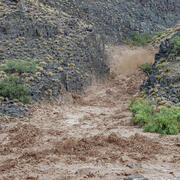
Flash floods triggered by strong rainfall can cause loose rock and sediment to mobilize and pour off cliffs and flow down tributary drainages, especially during intense summer monsoon storms. These events present an extreme hazard to hikers and river campers and have resulted in fatalities, injuries and property damage.
"We have never been able to reach people in Grand Canyon with flash flood warnings like this before. We are grateful for the coordination to make this possible and have the chance to save lives," said Megan Taylor, Lead Meteorologist at the National Weather Service Flagstaff Field Office.
The USGS provided expertise in satellite communication technology and applied geospatial data analysis that integrated river campsites, tributary drainages, geology at campsites and the Colorado River Mile System. The scientists drew on decades of USGS research and firsthand experience working in the Grand Canyon backcountry to incorporate the kinds of data that would be most meaningful to river users. The alert system is a vital piece of a larger risk communication plan designed to increase awareness around the risk to public safety posed by flash flood and debris flow events in the Grand Canyon region.


While the new alert system was developed specifically for Grand Canyon, the framework it uses could apply to most wilderness areas and be utilized by land management agencies, search and rescue units and those concerned with public safety to increase communication with people visiting or living in areas that are outside of cellular signal coverage. More than a million people spend the night in National Park Service-managed backcountry wilderness areas every year.
“This new alert system provides a critical communication link in remote areas, giving backcountry users timely information about flash floods or other hazards they may encounter," said Ed Keable, Superintendent of Grand Canyon National Park. “At the same time, no technology replaces the need for personal preparation and situational awareness. Visitors should always research their route, understand the risks, and be ready to adapt when conditions change.”
To subscribe for alerts, visitors can text GCRIVERALERTS to 928-707-7842 from the device they wish to subscribe to be added to the Grand Canyon River Alerts list that is maintained by Coconino County Emergency Management. Subscriptions must be made prior to leaving on a backcountry visit. For more information about how to subscribe, click here.
# # #
The USGS provides science for a changing world. Learn more at https://www.usgs.gov or follow us on Facebook @USGeologicalSurvey, YouTube @USGS, Instagram @USGS, or X at @USGS.
Related
A New App to Report Flash Floods and Debris Flows in Grand Canyon
Related