
Lidar Error Dictionary
The purpose of this dictionary is to provide standardized language to describe commonly encountered errors associated with lidar datasets submitted to the USGS data validation unit for ingestion into the National Map. This document will improve communication between 3D Elevation Program operations personnel, the project’s point of contact, contributors, partners, and contractors.
Download a pdf copy of this data dictionary
The error dictionary is in two parts--Part 1 (this page) covers Breakline and Classified Point Cloud deliverables. Part 2 covers Digital Elevation Model, FGDC XML Metadata, Reports, Spatial Metadata, and Raster Metadata deliverables.
Part 1
Breakline Deliverable
Classified Lidar Point Cloud Deliverable
Point Misclassification Errors
Part 2:
Digital Elevation Model Deliverable
FGDC XML Metadata Deliverable
Reports Deliverable
Spatial Metadata Deliverable
Raster Metadata Deliverable
* Click on an image for a larger view
Deliverable: Breaklines
Error type: Breakline Enforcement
Error subtype: n/a

Error definition: Appears as though the breakline was not enforced to the water feature, bridge, island, or structure correctly.
Error type: Geometry Error:
Error in feature’s breakline shape, length, or elevation.
Error subtype: Downstream Constraint

Definition: Water feature does not present a gradient downhill surface that follows the immediately surrounding terrain.
Error subtype: Overextended Breakline

Definition: Breakline that goes beyond the full extent of the water body.
Error subtype: Under-extended breakline

Definition: Breakline that underrepresents the full extent of the water body.
Error subtype: River/Stream segments

Definition: A stream or river feature that is broken up into discontinuous segments when it should be a single collected water feature.
Error subtype: Z-Values

Definition: The elevation value of a breakline’s vertices are not at or below the immediately surrounding terrain. This can result in waterbodies that appear to be sunken or floating.
Error subtype: Z-Enabled

Definition: A breakline that has no elevation values and is a 2D feature. A 3D feature is required.
Error type: Missing Feature:
A breakline is absent for a feature that requires breakline collection. This can be a water feature, structure, bridge, part of a breakline, or island.
Error subtype: Breakline

Definition: A segment or piece of a breakline on a feature that is missing.
Error subtype: Bridge

Definition: There is a bridge artifact, not caused by a point misclassification, that requires a breakline in order to remove it completely.
Error subtype: Island

Definition: There is an island greater than the contracted collection size that is not encompassed with a breakline.
Error subtype: River/Stream

Definition: There is a river or stream that meets the contracted collection size that is not encompassed with a breakline.
Error subtype: Structure
Definition: A breakline is absent for a building or non-organic feature that requires breakline collection or a breakline is needed to remove artifacts.
Error subtype: Waterbody
Definition: Spatial Reference information is incorrect or is not correctly reported for some or all Breaklines.
Error type: Spatial Reference
Error subtype: n/a
Definition: Spatial Reference information is incorrect or is not correctly reported for some or all Breaklines.
Deliverable: Classified Lidar Point Cloud
Error type: Collection:
Errors that are related to the processing and creation of lidar point cloud data.
Error subtype: Corrupt File
Definition: LAS files will not load into visualization software or there is an invalid data type.
Error subtype: Data Void


Definition: Lapses in lidar data collection in the point cloud that are not due to surface environmental conditions. Examples would include but are not limited to lapse in coverage due to atmospheric interference, GPS outages, or cloud cover.
Error subtype: Density

Definition: Point density for specific file(s) appears to be excessively high or low compared to the expected values.
Error subtype: LAS Version
Definition: Lidar point cloud data is stored in a version of LAS format inconsistent with Lidar Base Specification, American Society for Photogrammetry and Remote Sensing (ASPRS) guidelines, or contract/task order.
Error subtype: Relative Accuracy


Definition: Issues pertaining to the geometric accuracy of the point cloud. These errors can be related to the interswath and intraswath precision and may or may not have visual indication in the DEM surface.
Error type: Header Properties:
The LAS file header characteristics are incorrect according to the LAS version, Lidar Base Specification, American Society for Photogrammetry and Remote Sensing (ASPRS) guidelines, or contract/task order.
Error subtype: EVLR/VLR
Definition: Incorrect treatment of the Extended Variable Length or Variable Length Records. Typically, when one or many records are not superseded.
Error subtype: File Creation
Definition: The file creation (day and/or year) was incorrectly populated.
Error subtype: File Source ID
Definition: The file source ID is set incorrectly.
Error subtype: Generating Software
Definition: The type of software used to generate the LAS files was incorrectly populated.
Error subtype: Global Encoder
Definition: The global encoder value is set incorrectly.
Error subtype: PDRF/PDRL
Definition: The Point Data Record Format or Point Data Record Length are set to the incorrect value.
Error subtype: Spatial Reference
Definition: The Coordinate Reference System information is incorrect for some or all LAS files.
Error subtype: System ID
Definition: The system ID is not populated with an acceptable value.
Error subtype: XYZ Scale Factor
Definition: Scale factor not appropriately populated or applied.
Error subtype: XYZ Offset
Definition: Overall offset for point records is an incorrect value.
Error type: Point Data Records:
Properties of the LAS Points are incorrect for some or all LAS files according to applicable USGS Lidar Base Specification, American Society for Photogrammetry and Remote Sensing (ASPRS), or contract/task order.
Error subtype: Classification Flags


Definition: Classification flags are set incorrectly. This includes overlap, withheld, key-point, and synthetic flags. Text field will be used to specify.
Error subtype: Edge of Flight Line
Definition: The Edge of Flight Line data bit is set incorrectly.
Error subtype: GPS Time
Definition: The Global Positioning System of a LAS file is incorrect. Either incorrect GPS time format, incorrect date, or missing information.
Error subtype: Intensity

Definition: Intensity values of the LAS points are not normalized to 16 bit and/or did not use linear normalization.
Error subtype: Point Source ID

Definition: Point Source ID values are set incorrectly.
Error subtype: Return 0
Definition: A pulse return of 0 has been found in some or all LAS files.
Error subtype: Scan Angle
Definition: The Scan Angle Rank appears to be an incorrect value.
Error subtype: Scan Direction Flag
Definition: The Scan Direction Flag bit is set incorrectly.
Error subtype: XYZ Position
Definition: There is an issue with the X, Y, Z values in some or all the LAS files.
Error type: Point/Header Mismatch:
There is a discrepancy between the information recorded in the points and their respective header information.
Error subtype: Point Count
Definition: Point count header information does not match the actual point count.
Error subtype: Return Counts
Definition: Return count header information does not match the actual return count.
Error subtype: Returns
Definition: Return header information does not match the actual returns.
Error subtype: XYZ Min/Max
Definition: The X, Y, and/or Z header information does not match the X, Y, and/or Z point information.
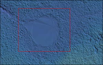
Error type: Point Misclassification
Error subtype: n/a
Definition: There is an incorrect classification of points. Text field will be used to specify.


