Prepare for the Next Volcanic Eruption in the Pacific Northwest
The Pacific Northwest’s volcanoes aren’t just landmarks—they’re active systems. Know the hazards and be ready for the next eruption.
Understanding Volcanic Hazards
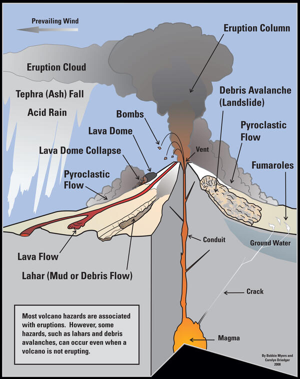
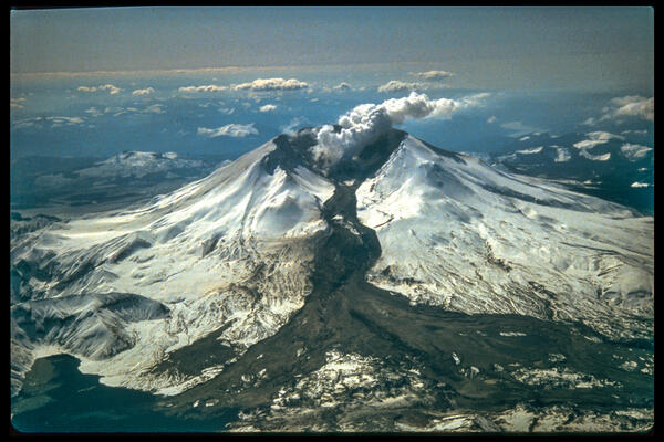
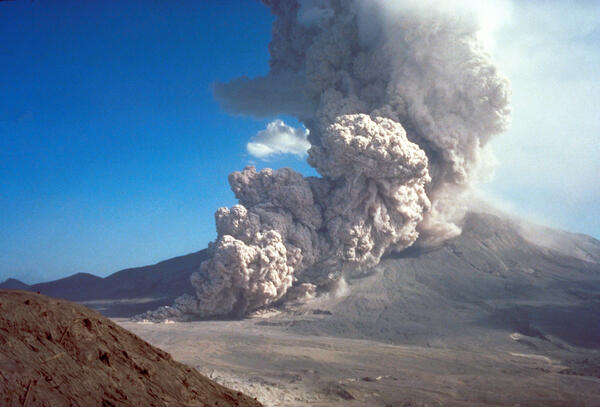
Volcanoes can produce a wide range of dangerous hazards—often with little warning. Eruptions may generate lava flows, ash clouds, and fast-moving avalanches of hot rock, ash, and gas known as pyroclastic flows. These intense hazards race down steep slopes, destroying nearly everything in their path.
Eruptions can also rapidly melt snow and ice, creating powerful mudflows called lahars. These concrete-like flows can travel dozens of miles along river valleys, impacting areas far from the volcano. Lahars can also occur without an eruption, when unstable, water-saturated slopes collapse.
Some hazards strike close to the volcano, while others—like ashfall and lahars—can affect communities many miles away.
Stay Out of Hazard Zones
When closures or evacuation orders are in place, take them seriously. Dangerous conditions near a volcano can change quickly, and areas that appear safe may not be. Hazards such as pyroclastic flows, debris avalanches, lava flows, and toxic gases can be deadly. Follow all official guidance and stay out of restricted areas.
Key Hazards to Know
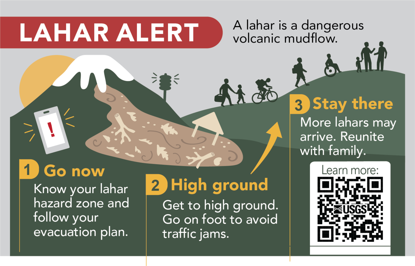
Lahars
Fast-moving mixtures of mud, rock, and water that surge down river valleys like wet concrete. If you are in a lahar-prone area:
- Know the quickest route to high ground (at least 100 ft / 30 m above the valley floor)
- Evacuate immediately if you receive an alert or notice warning signs
- Avoid river channels during heavy rain or volcanic activity
- Keep an evacuation plan and go-bag ready
Volcanic Ash
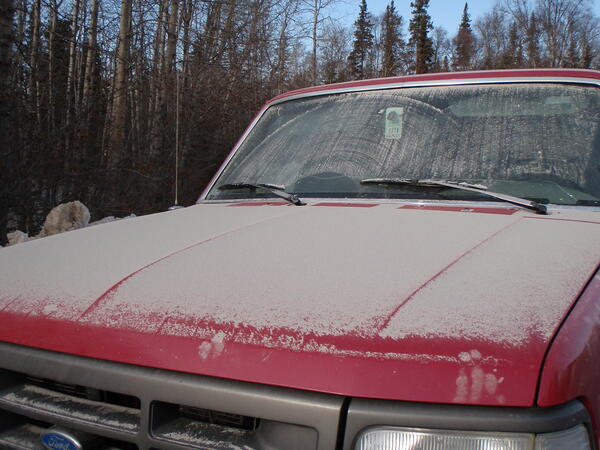
Volcanic ash falls unpredictably depending on wind direction at the time of eruption. Ash most commonly blows eastward, but not always. Unlike wildfire ash, volcanic ash is dangerous because its tiny, sharp, rock and glass-like fragments can harm lungs, irritate eyes and skin, damage engines, and become heavy enough to collapse roofs.

Lava Flows
Molten rock that moves downslope, burning or burying everything in its path and often starting fires. In many cases, lava flows move slowly enough for people to evacuate safely—but they remain highly destructive.
Pyroclastic Flows
Extremely fast-moving currents of hot gas, ash, and rock that can reach speeds of hundreds of miles per hour. These are among the most dangerous volcanic hazards and are almost always deadly.
We are all in this together. Everyone has a role in preparedness.
Role of the United States Geological Survey Volcano Observatories:
The United States Geological Survey (USGS) monitors volcano activity, assesses hazards, and provides scientific information to support public safety. Volcano observatories track changes in unrest, issue warnings of potential eruptions, and share timely updates through the Volcano Hazards Program, observatory websites, the Volcano Notification Service (VNS), and the media. USGS scientists also support the development of coordinated response plans with emergency managers and other partners.
Role of public officials:
Public officials help keep communities safe by developing, maintaining, and practicing emergency response plans. They provide hazard education, communicate risks, and issue alerts and instructions before and during volcanic activity. This includes implementing closures, directing evacuations, and guiding recovery efforts after an event.
Role of the public:
Prepared communities are safer communities. Residents can reduce risk by learning about local volcanic hazards before an event occurs and following guidance from officials during an emergency. Review hazard maps to understand your exposure, plan evacuation routes, and prepare your home or business in advance. Staying informed and ready can significantly reduce impacts when activity begins.
Lahar Preparedness Information by State
Washington
| Washington State Emergency Management Division | Washington State Level Volcano Preparedness Information State Level Emergency Alerts (Sign-Up)! | |
| Pierce County Emergency Management | Pierce County Volcano Preparedness Information Evacuation Maps by Community in Pierce County | https://www.piercecountywa.gov/3730/Mount-Rainier-Active-Volcano https://www.piercecountywa.gov/3814/Evacuation-Routes-and-Information |
| Thurston County Emergency Management | Thurston County Volcano Preparedness Information | https://www.thurstoncountywa.gov/departments/emergency-management/threats-hazards/volcano |
| King County Emergency Management | King County Volcano Preparedness Information | https://kingcounty.gov/en/dept/executive-services/health-safety/safety-injury-prevention/emergency-preparedness/volcano |
| East Pierce Interlocal Coalition (EPIC) | Volcano Information and evacuation maps for Puyallup, Sumner-Bonney Lake, Orting, White River, Carbonado | https://www.epiceoc.com/pages/lahar |
| East Pierce Regional Lahar Drill | East Pierce Interlocal Coalition school districts (Puyallup, Sumner-Bonney Lake, Orting, White River, Carbonado), full-scale lahar evacuation drill. | https://laharexercise.com/ |
| Mount Rainier National Park | Mount Rainier National Park Official Information | https://www.nps.gov/mora/index.htm |
| Mount St. Helens National Volcanic Monument | Mount St. Helens National Volcanic Monument Official Information | https://www.fs.usda.gov/visit/national-monuments/mount-st-helens |